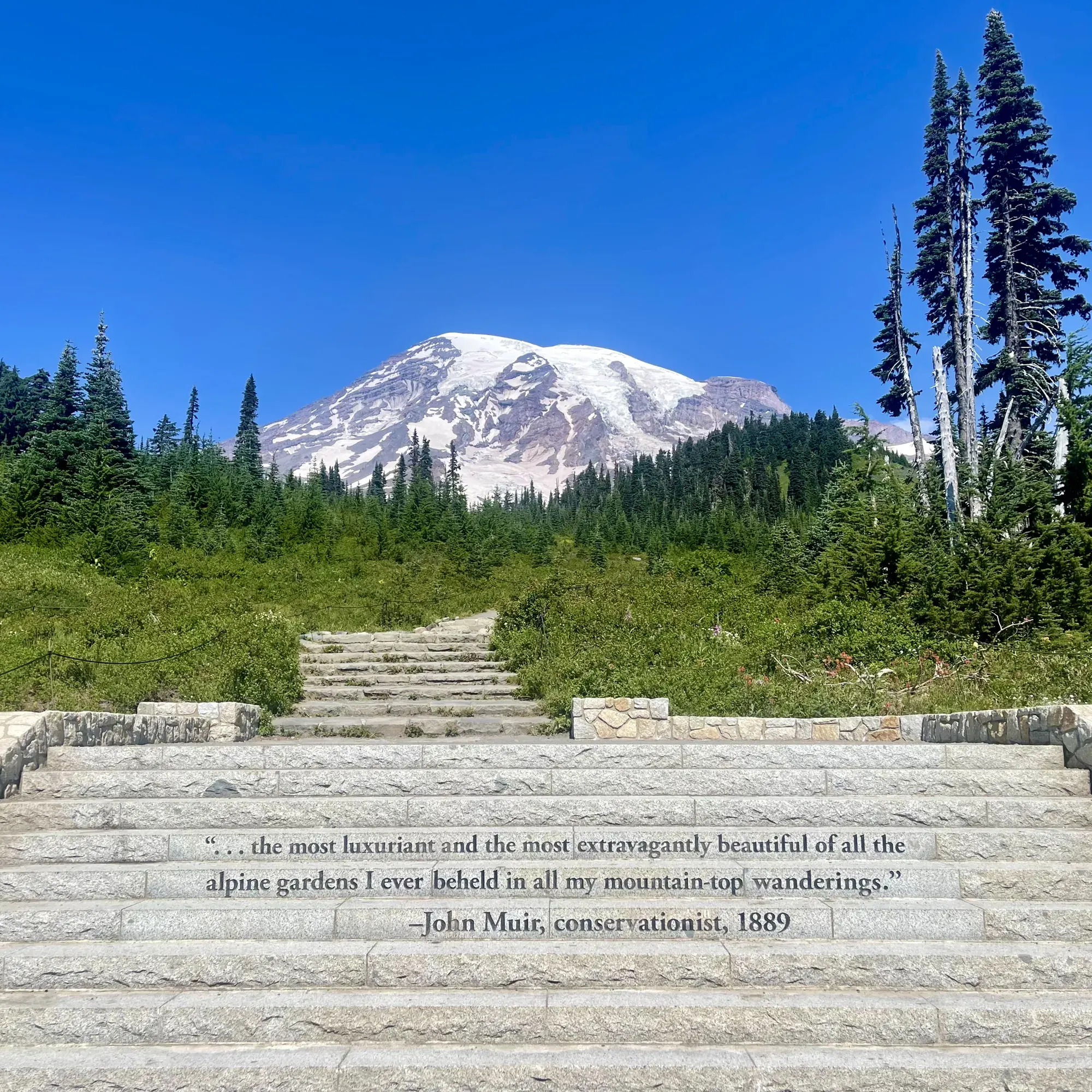
Skyline Trail Loop
The Skyline Trail loops through the Paradise area and reaches Panorama Point. The clockwise route passes the Stevens–Van Trump Memorial and Myrtle Falls before returning to Paradise.
Mount Rainier · Photo: David & Keri New
- 5.5 miDistance
- 1,700 ftElevation gain
- 4.5 hrTime
- StrenuousDifficulty
The numbers, with sources
Distance: 5.5 miles round-trip loop Source
Gain: 1,700 feet Source
Time: 4.5 hours round trip Source
Trailhead: Stone steps near the entrance to Jackson Visitor Center at Paradise Source
Route type: loop Source
Built from official sources (checked Nov 3, 2026). Confirm current conditions with the park.
Recreation.gov permits, entrances & campgrounds
Recreation.gov (RIDB). Booking records date not published. NPS guidance above takes precedence. A listing doesn’t mean you need a permit or that there’s space on your dates.
Nearby campground records
Within 10 straight-line miles of the trailhead. Distances are straight-line from map coordinates, not driving distances.
- White River Campground: approximately 9.2 miles straight line. RIDB coordinates · Mapped route source
- OHANAPECOSH GROUP CAMPGROUND: approximately 8.7 miles straight line. RIDB coordinates · Mapped route source
- OHANAPECOSH CAMPGROUND: approximately 8.7 miles straight line. RIDB coordinates · Mapped route source
- COUGAR ROCK CAMPGROUND: approximately 3 miles straight line. RIDB coordinates · Mapped route source
- COUGAR ROCK GROUP CAMPGROUND: approximately 3 miles straight line. RIDB coordinates · Mapped route source
Park campground options (5)
These records belong to the park’s NPS recreation area. We haven’t checked how close these are to the trail, when they open or whether sites are free; check the map and the booking page.
White River Campground — Campground; RIDB reservable: yes. Season: not published in structured RIDB data. Recreation.gov (RIDB) source · Booking details
NPS reservation guidance: When open for the summer, all sites are first-come, first-serve. The campground does not take reservations. NPS source
OHANAPECOSH GROUP CAMPGROUND — Campground; RIDB reservable: yes. Season: not published in structured RIDB data. Recreation.gov (RIDB) source · Booking details
OHANAPECOSH CAMPGROUND — Campground; RIDB reservable: yes. Season: not published in structured RIDB data. Recreation.gov (RIDB) source · Booking details
NPS reservation guidance: Reservations can be made online or by telephone 1-877-444-6777. Ohanapecosh campsites tend to open in mid to late May as weather allows. From opening until the end of June, all open sites are first-come, first-serve. For summer dates June 23, 2016, through early September reservations can be made up to 6 months in advance. Reservations are highly recommended as this campground is very popular. NPS source
COUGAR ROCK CAMPGROUND — Campground; RIDB reservable: yes. Season: not published in structured RIDB data. Recreation.gov (RIDB) source · Booking details
NPS reservation guidance: Reservations can be made online or by telephone 1-877-444-6777. Cougar Rock campsites tend to open in mid to late May as weather allows. From opening until the end of June, all open sites are first-come, first-serve. Reservations are accepted up to 6 months in advance. NPS source
COUGAR ROCK GROUP CAMPGROUND — Campground; RIDB reservable: yes. Season: not published in structured RIDB data. Recreation.gov (RIDB) source · Booking details
Route, junction by junction
Jackson Visitor Center / Paradise Meadows trailhead → Panorama Point
Start near the entrance to Jackson Visitor Center at the stone steps inscribed with a John Muir quotation. Follow the loop clockwise, climbing for 2 miles to Panorama Point. NPS identifies a toilet at Panorama Point. Throughout the Paradise meadows, stay on the constructed trail and rest on rocks or benches to avoid damaging the subalpine plants. Source
Distance: 2 miles climbing clockwise from the trailhead Source
Panorama Point → High Skyline connection above Golden Gate junction
Beyond Panorama Point, take High Skyline to avoid the dangerous icy slope NPS says does not melt. High Skyline reconnects with Skyline above the Golden Gate junction. NPS identifies Golden Gate as an alternative for a shorter hike but does not give a separate distance for that alternative on this page. Source
Junction: High Skyline Trail: Use High Skyline beyond Panorama Point to avoid the permanent icy slope. Source
Junction: Golden Gate Trail: High Skyline rejoins Skyline above this junction; Golden Gate is an alternative for a shorter hike. Source
Skyline near Golden Gate junction → Stevens–Van Trump Memorial / Paradise Glacier junction
Continue on Skyline toward the Stevens–Van Trump Memorial. NPS describes another 0.75 mile to the memorial and its Paradise Glacier Trail junction after describing the High Skyline reconnection above Golden Gate. NPS doesn’t give the mileage at that reconnection, so this page doesn’t give a total distance to the memorial. Source
Distance: Another 0.75 mile to the memorial and Paradise Glacier Trail junction after the described reconnection Source
Junction: Paradise Glacier Trail: Skyline reaches this junction at the Stevens–Van Trump Memorial; the described loop continues into Paradise Valley. Source
Stevens–Van Trump Memorial → Myrtle Falls and Paradise
Descend into Paradise Valley from the memorial junction. The route then climbs slightly to Myrtle Falls before returning to Paradise and completing the loop. NPS describes the overall trail as offering subalpine wildflowers, a close view of Mount Rainier and the Nisqually Glacier, and clear-day views south to Mount Hood; those are route-wide highlights rather than promised views at a particular waypoint. Source
No elevation profile: we only draw one from a mapped route we can verify. Route source
In-depth guide
Compiled from linked sources, checked Nov 2, 2026. Each paragraph links to its source.
Is this hike for you?
The Skyline Trail starts at Paradise, which sits at 5,400 feet, and trails here can be steep and strenuous. A snow-free start at Paradise can still lead to snow higher up, and lingering patches can make an easy trail hard or unsafe. Talk through everyone’s skills before going above the lower meadows, and have a shorter walk in mind. Source · Source 2
Getting there and parking
Paradise is 19 miles east of Nisqually Entrance and 12 miles east of Longmire. The upper Paradise lot is day use only; don’t park in the passenger drop-off areas. The lower lot allows day use and authorized overnight parking, and there’s overflow parking at the picnic area and on Paradise Valley Road (closed in winter). Overnight parking needs a backcountry camping permit or a hotel reservation, and sleeping in vehicles in lots or pullouts isn’t allowed. Source · Source 2 · Source 3
The private-vehicle entrance pass is $30 for seven consecutive days and covers everyone in the car. Entrances and campgrounds are cashless. Washington’s Discover Pass doesn’t cover Mount Rainier. Source
Winter access
All vehicles, including AWD and 4WD, must carry tire chains from November 1 through May 1, and posted rules can require chains on every vehicle. On busy days the park may meter the Longmire gate, letting one car up as another comes down, even in sunny weather. Check alerts after 4 p.m. the day before and after 7 a.m. on the day of your visit. Snow camping has its own rules; bring supplies for extra nights in case road closures hold you up. Source · Source 2 · Source 3 · Source 4 · Source 5 · Source 6
Snow on the trail
Snow bridges can hide streams and collapse; listen for muffled running water, and stay off overhanging cornices. Watch for tree wells and gaps beside logs and rocks. If a steep snowy crossing could mean a disastrous fall, turn around, as the park advises. Where snow or mud covers the trail, stay on it anyway to protect the meadow plants, and don’t pick flowers for photos. Source · Source 2 · Source 3
Restrooms and water
The 2026 winter schedule listed the Plaza (Slate) restrooms by the upper-lot plaza as open 24 hours daily, while the picnic area and its restrooms were closed for the season. Check current hours, and don’t count a restroom as a water source. Source · Source 2 · Source 3
Wildlife
Stay at least 50 yards (150 feet) from park wildlife and 300 feet from bears. Marmots and ground squirrels that get human food can become aggressive and bite, so keep food and trash packed away and pick up every crumb. Source
Shorter options
The lower Skyline walk to Myrtle Falls is one mile and wheelchair accessible with help, but only when it’s snow-free. Alta Vista Trail is 1.7 miles, and Deadhorse Creek with Moraine Trail is 2.5 miles; the same snow hazards apply. Source
Sources & planning limits
Reviewed 2026-11-03. Check current conditions for your trip dates.
Getting there and back
Reach Paradise via the Longmire–Paradise road. Regular winter nightly gate closures began October 29, 2026; the road is assessed each morning, and weather may delay opening or keep the gate closed all day. Source
Return: The official clockwise loop returns to Paradise after descending into Paradise Valley and climbing slightly to Myrtle Falls. Golden Gate is listed as an alternative for a shorter hike, but the opened Skyline page does not publish its mileage or a separate return itinerary. The full described Skyline loop is 5.5 miles round trip. Source
Water
A toilet is provided at Panorama Point. Treat water before drinking; no potable-water supply is identified on the trail page. Source
Treat water before drinking. The Skyline page doesn’t name a tap or a reliable refill spot, and the toilet at Panorama Point doesn’t mean there’s drinking water. Source
General Mount Rainier heat guidance says to drink before feeling thirsty and bring extra water in case it is needed. NPS notes that high altitude increases fluid loss and advises taking breaks and resting in shade in hot conditions. Source
Hazards
Persistent icy slope
Beyond Panorama Point, NPS directs hikers onto High Skyline to avoid a dangerous icy slope that does not melt. Do not treat a summer calendar date as proof that this slope is safe. Source
Early-season snow
The Skyline page warns that early-season hiking may be hazardous and directs visitors to current trail conditions. General park guidance says higher-elevation snow may linger into June or July. Source
Rapid weather changes and poor visibility
Weather can change rapidly at Mount Rainier. General NPS advice says not to travel in poor visibility, not to travel alone, and not to depend on cellular coverage. Tell someone the intended route and return plan. Source
Thunderstorms
NPS advises checking the forecast and considering postponement to avoid lightning. If thunder is heard, seek safe shelter immediately; the park identifies a substantial building or hard-topped vehicle as the safe place. Avoid viewpoints during a storm. Source
Heat and sun
NPS recommends sunscreen, a hat, sunglasses and lightweight, light-colored clothing for hot days. Sunlight reflected from snow can cause sunburn. Select an activity suited to the conditions and carry extra water. Source
Season
NPS warns that early-season hiking may be hazardous and directs visitors to check current trail conditions. This page does not publish fixed opening dates. Source
There is no fixed opening date on the Skyline description. It warns specifically that early-season hiking may be hazardous and asks visitors to check current conditions before starting. Snow lingering into June or July is a general higher-elevation park warning, not a guaranteed trail clearance date. Source
The Paradise access road has winter gate controls. The opened road-status page says regular nightly closures at the Longmire gate began October 29, 2026; the road is assessed each morning, and weather can delay opening or keep it closed all day. This concerns road access rather than an announcement that Skyline is snow-free. Source
Gear & rules
Stay on constructed trails to protect delicate subalpine plants. Source
Paradise is day use only; no overnight camping. Source
Fires and pets are prohibited on trails; treat water before drinking. Source
Filling a gap in your kit? Compare these packing essentials on Amazon. Choose gear for your route, conditions and the park’s guidance.
As an Amazon Associate we earn from qualifying purchases. How this works
Paradise is day use only, with no overnight camping on this loop. NPS explains that areas such as Paradise were closed to overnight camping because concentrated use damaged fragile resources. Use only constructed trails. Source
Fires are prohibited, and pets are not allowed on trails. The park’s broader statement excludes pets from wilderness, off-trail areas and winter-closed roads, with service animals excepted. Source
Wear sturdy footwear with non-slip tread and ankle support. For snow or rain, NPS recommends waterproof footwear with some insulation. Carry the ten essentials even for a short sightseeing hike. Source
Protect fragile subalpine vegetation by staying on the trail and resting on rocks or benches. Check current trail conditions through wilderness information centers, ranger stations or visitor centers before starting. Source
Pace
NPS gives 4.5 hours as the round-trip hiking time for the 5.5-mile Skyline loop. It does not assign times to Panorama Point, High Skyline, the memorial or Myrtle Falls individually. Source
Questions
Which direction does the NPS description follow?
Clockwise. It climbs 2 miles to Panorama Point, uses High Skyline beyond the point, passes the memorial and Paradise Glacier junction, and returns through Paradise Valley and Myrtle Falls. Source
Is a shorter option identified?
Yes. NPS identifies Golden Gate Trail as an alternative for a shorter hike, at a junction below the High Skyline reconnection. The Skyline page does not give a mileage or time for this shortcut. Source
Where is the on-route toilet?
NPS identifies a toilet at Panorama Point. The trail description does not identify a drinking-water tap there. Source
Can visitors camp in the Paradise meadows?
No. Paradise is day use only, and the Skyline page lists no wilderness camps. Stay on the constructed trails to reduce impacts to the fragile environment. Source
What can be seen from the trail?
NPS describes subalpine wildflowers, Mount Rainier and the Nisqually Glacier. On clear days, views extend south to Oregon’s Mount Hood. Visibility depends on conditions; the page does not assign every view to a specific viewpoint. Source
When does NPS suggest visiting to avoid congestion?
For summer and fall, NPS suggests visiting earlier or later in the day, or on a weekday. Source
Can a wheelchair or stroller reach Myrtle Falls?
NPS describes the Skyline Trail to Myrtle Falls as a one-mile roundtrip option suitable for wheelchairs with help and strollers. This guidance applies to that short portion of the trail. Source
Can visitors step off the trail to photograph flowers or feed marmots?
NPS says to stay on the trail at all times to protect delicate subalpine vegetation and not to feed any wildlife. Source
Alternatives
Nisqually Vista: Easy paved 1.2-mile round-trip trail with 200 feet of gain from the lower Paradise parking lot; stairs at the start, and snow cover in winter. Source
Camp near Skyline Trail Loop
Closest campgrounds by drive time to Skyline Trailhead:
- 24 min Cougar Rock (9.6 mi, in the park)
- 51 min Ohanapecosh (23.2 mi, in the park)
- 51 min Big Creek (Gifford Pinchot National Forest, WA) ↗ (23.2 mi, USDA Forest Service)
- 1 hr 3 min La Wis Wis Campground ↗ (28.2 mi, USDA Forest Service)
- 1 hr 20 min Soda Springs Campground ↗ (33.2 mi, USDA Forest Service)
Driving time with no traffic (OSRM, OpenStreetMap roads). Some park roads are shuttle-only in season. All camping near Mount Rainier
More Mount Rainier trail guides
- Burroughs Mountain Trail4.7 mi · Strenuous
- Naches Peak Loop3.4 mi · Easy
- Rampart Ridge Loop4.6 mi · Moderate