What to see & do
What to see & do
Official data, not firsthandThings to see
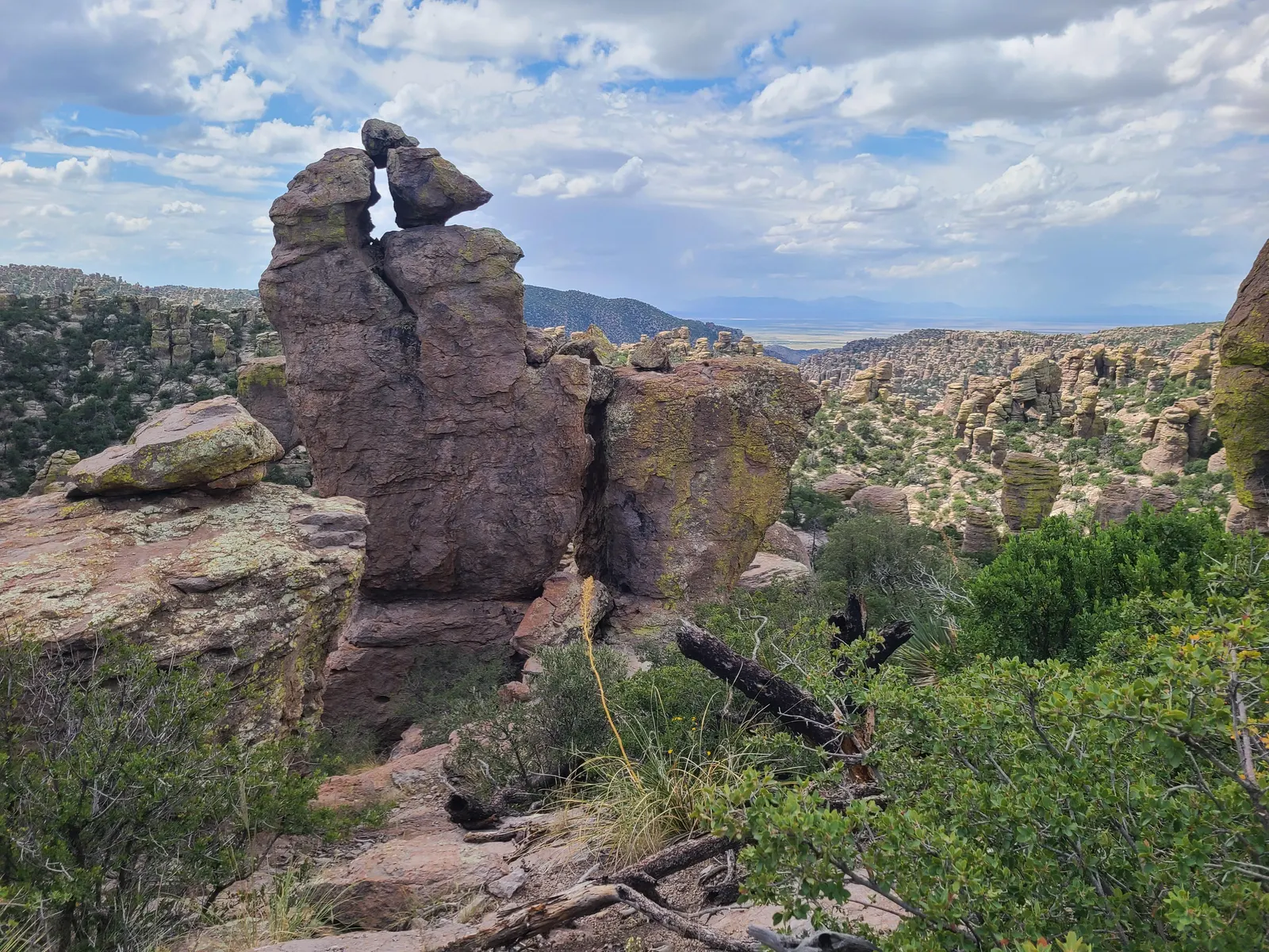
Massai Point
See balanced rocks, surrounding valleys, and mountain views from the overlook and nature trail. Last verified · nps.gov
Echo Canyon Grottoes
See tunnel-like rock formations among pinnacles and balanced rocks. Last verified · nps.gov
Heart of Rocks
See unusual formations, including Pinnacle Balanced Rock and Big Balanced Rock. Last verified · nps.gov
Sugarloaf Mountain
See surrounding canyons and a Civilian Conservation Corps fire lookout at the 7,310-foot summit. Last verified · nps.gov
Bonita Creek
See an intermittent creek, grassland birds, and lower-canyon habitat. Last verified · nps.gov
Wildlife: what to look for, where and when (7)
- Coues’ white-tailed deer
- Scenic drive and Silver Spur Meadow Trail. Watch for deer while driving. Last verified · nps.gov
- White-nosed coati (coatimundi)
- Silver Spur Meadow and Bonita Canyon Campground at lower elevations · Daytime; bands are often seen in fall and winter. Look for groups of females and young foraging. Last verified · nps.gov
- Hooded and striped skunks
- Bonita Canyon Campground · Primarily at night. Keep a clean campsite. Last verified · nps.gov
- Javelina
- Lower elevations; forests and grasslands. Keep a safe distance from wild animals. Last verified · nps.gov
- Acorn woodpecker
- Silver Spur Meadow Trail and Lower Rhyolite Trail. Look along creeks; NPS identifies these trails as common viewing locations. Last verified · nps.gov
- Mexican jay
- Parking areas · Year-round. NPS says these birds often beg for food; feeding is prohibited. Last verified · nps.gov
- Turkey vulture
- Cliffs above Bonita Canyon Campground amphitheater · Summer evenings. Watch birds returning to roost. Last verified · nps.gov
Keep your distance: Do not feed or approach wildlife. Keep a safe distance and use binoculars; store food securely. Last verified · nps.gov
Sightings are never guaranteed.
Sunrise, sunset & night sky (3)
- Faraway RanchNight sky
- Faraway Ranch parking lot · Road and restrooms remain open at night; overnight parking is prohibited. International Dark Sky Park. NPS recommends this open-sky location and avoiding a full moon. Last verified · nps.gov
- Echo CanyonNight sky
- Echo Canyon parking lot · Road and restrooms remain open at night; overnight parking is prohibited. International Dark Sky Park. NPS recommends this open-sky location and avoiding a full moon. Last verified · nps.gov
- Massai Point sunsetSunset
- Massai Point · NPS describes the park as open 24 hours for sunrise, sunset and stars. NPS publishes a sunset view here; exact seasonal sunrise and sunset times are not published on this page. Last verified · nps.gov
Beyond hiking: kids, rangers & Junior Ranger (6)
- Junior Ranger
- Visitor center · During visitor center open hours. All ages; pick up a free activity booklet and share completed work with staff to receive a badge. Last verified · nps.gov
- Ranger-led programsRanger program
- Park; ask staff for locations. NPS confirms ranger-led programs continue; ask the visitor center for the current schedule. Last verified · nps.gov
- Bonita Canyon DriveScenic drive
- Bonita Canyon to Massai Point · Year-round. Allow 60-90 minutes for the 8-mile paved drive. No trailers or vehicles over 24 feet beyond the campground. Last verified · nps.gov
- Birdwatching
- Bonita Creek Trail, Silver Spur Meadow Trail, and Echo Park · Year-round. NPS identifies these areas as good birdwatching locations; over 200 bird species have been documented. Last verified · nps.gov
- Discovery DaypackKids
- Visitor center · During visitor center open hours. Borrow a free pack with field guides, binoculars, and a magnifying glass. Last verified · nps.gov
- Faraway Ranch history stop
- Faraway Ranch Historic District. Read about the Erickson homestead and later guest ranch. Current interior-tour schedule not published on the reviewed history page. Last verified · nps.gov
Visitor centers & hours (1)
- Visitor Center
- The visitor center is on the right 2 miles after the entrance. Open from 8:30 am to 4:30 pm, it has an information desk, museum, park film, and gift shop. It provides free maps, junior ranger booklets, and information.
Hours: Daily 8:30 am–4:30 pm
Passport stamp here.
Last verified · NPS
Hours from the National Park Service’s visitor-center data. Holiday closures and seasonal changes happen, so check the link before a long drive.
Official park & trail maps (2)
- Park Map Whole park · PDF
- Park Guide & Map Trails · PDF
Download before you go; many parks have little or no cell service. Maps from nps.gov, checked Nov 1, 2026.
Travel times & internal access (1)
| From → to / access mode | Distance | Time |
|---|---|---|
| Park entrance → Massai PointNPS allows 60–90 minutes for the scenic-drive activity with stops.Last verified · nps.gov | 8 miles | About 30 minutes without stops |
Distances and times as the park publishes them. Road work, shuttles, wildlife jams and seasonal closures add time.
Cell, gas, food & EV charging (2 areas)
- Park and approach roads
Cell: Limited cell service near the park; download directions before arrival.
Gas: No stations between Interstate 10 and the park; fill up beforehand.
Last verified · nps.gov- Willcox and Sunizona
Gas: Nearest gas: Sunizona, 27 miles southwest; Willcox, 37 miles northwest.
Food: Restaurants, groceries, soft drinks, and ice are available in these towns.
Last verified · nps.gov
Coverage reports are not guarantees; carriers and chargers change.
Scenic drives, trail guides & tours
Trail guides for this park
- Bonita Canyon Drive
- An 8-mile paved drive up through rock formations and oak, cypress and pine forest to Massai Point’s 360-degree view of the Wonderland of Rocks, passing Faraway Ranch, the visitor center and the campground. Allow 60-90 minutes. Vehicles over 24 ft and trailers can’t go past the campground. Last verified · nps.gov
Wildlife and where to see it → · All things to do →
Required gear & rules
Required (2)
| Item | Where / when | Spec / exceptions | Source |
|---|---|---|---|
| Wildlife-proof food, scented item and garbage storage | parkwide; Bonita Canyon Campground · 2026 compendium | When not being prepared or consumed, food, food-scented items and garbage must be secured in vehicles or containers that prevent wildlife access. Campers should use the metal food-storage boxes at each campsite. · While food is being prepared or eaten | Source |
| Bury human waste; pack out toilet paper | Undeveloped areas · 2026 compendium | Hole at least 6 in deep, 200 ft from surface water, out of sight of trails and away from campsites | Source |
Prohibited (7)
| Item | Where / when | Spec / exceptions | Source |
|---|---|---|---|
| Drones | parkwide (Chiricahua and Fort Bowie) · 2026 compendium (effective Jan 9, 2026) | Written superintendent approval | Source |
| Backcountry camping | Everywhere outside Bonita Canyon Campground · 2026 compendium | Overnight camping is restricted to established Bonita Canyon campsites; camping or overnight parking elsewhere requires superintendent permission. · Superintendent’s written permission | Source |
| Collecting firewood; fires only in campground grills | parkwide · Seasonal fire restrictions may apply. · 2026 compendium | Fires are permitted in government-provided grills at designated campsites. Use fuels designed for warmth or food preparation, such as charcoal briquettes or natural firewood. Portable fire containers require park staff or campground-host approval and must be fully contained, shielded and elevated at least 6 inches above ground. · Fires elsewhere with a superintendent’s permit | Source |
| Climbing the rock pinnacles | Chiricahua rock pinnacles; Fort Bowie ruin walls · 2026 compendium | — | Source |
| Vehicles over 24 ft and trailers on Bonita Canyon Road beyond the campground | Scenic drive beyond campground; Bonita Creek, Natural Bridge, Echo Canyon, Massai Point and Sugarloaf parking · 2026 compendium | Vehicles over 24 ft and trailers are prohibited beyond the campground on Bonita Canyon Road. Vehicles over 29 ft and day-use trailers may not proceed beyond Faraway Ranch paved parking. Day-use trailers must be disconnected there. · Reserved campers may bring vehicles up to 29 ft to their site from noon on the reservation day | Source |
| Pets on trails, wilderness and backcountry | All trails except listed ones · 2026 compendium | Leash max 6 ft where allowed · Bonita Creek, Faraway Ranch, Silver Spur Meadow and campground-visitor center connector; service animals | Source |
| Bicycles and e-bikes on hiking trails | All hiking trails · 2026 compendium | Bicycles may not use roads temporarily closed to motor vehicles. E-bikes, defined as two- or three-wheeled cycles with operable pedals and motors under 750 watts, may use only park roads open to the public. | Source |
Recommended (1)
| Item | Where / when | Spec / exceptions | Source |
|---|---|---|---|
| Traction devices (microspikes) in icy weather | Trails · December-March when snow and ice occur | — | Source |
Sun, moon & dark skies
Plan a sunrise, a golden-hour photo stop, or a night under the stars.
Approximate times at the NPS park coordinate (32.012, -109.342), using America/Phoenix. Terrain can hide the horizon; this is one reference point, not every location in the park.
Enable JavaScript to compute times for today or your chosen date.
- Sunrise
- —
- Sunset
- —
- Civil dawn
- —
- Civil dusk
- —
- Morning golden hour
- —
- Evening golden hour
- —
- Moon phase
- —
- Moon illumination
- —
- Moonrise
- —
- Moonset
- —
Tonight’s viewing windows
The selected date’s noon through the following noon; dates shown on both ends. Computed in 10-minute steps.
- Astronomical darkness
- —
- Milky Way core above 10° in darkness
- —
- Core window with the Moon below the horizon
- —
Computed opportunity, not a visibility forecast. Darkness means the Sun is at least 18° below the horizon. Core direction uses SIMBAD’s Sgr A* position and Earth’s sidereal rotation; season follows from the date. The Moon can wash out the core outside the moon-free window. Clouds, smoke, local lighting and terrain may prevent a view. No measured sky brightness or Bortle estimate is available here.
Dark-sky guidance
Listed as an International Dark Sky Place in the NPS certification list. Sourced designation list (source updated 2025-04-16; checked 2026-11-03). Check the DarkSky International directory for changes.
Choose a permitted viewing area with an open horizon, let your eyes adapt, and keep lights low and shielded. Confirm access and current alerts before heading out. NPS night-sky guidance
From NPS: night-sky reading
Sun and Moon calculations: SunCalc 1.9.0 (BSD license). Illumination and phase are at local noon; moonrise/set cover the selected civil day. Golden hour uses sunrise to Sun +6°, and Sun +6° to sunset. Missing events are reported explicitly. Coordinates and time-zone reference: existing NPS-sourced park data, checked 2026-11-03.
Accessibility guide: trails, lodging, campsites & visitor centers
Can everyone in our group go? Kids, a dog or a wheelchair at Chiricahua →
Odds of a dry trip
Choose a start date.
No wet days1 wet day2 or more
Wet day: 0.01 in (0.3 mm) or more of precipitation, 1996–2025. Station: CHIRICAHUA NM (USC00021664), 5,360 ft, 1 mi from park center, same station as our monthly weather. Station record · NOAA GHCN-Daily
Historical frequency at this station, not a forecast. Higher trails can be wetter or snowier than the station.
Time zone
- Park time
- Your time
- Difference
- No daylight saving time: clocks here do not change in March/November, so the offset to mainland DST-observing states changes by an hour seasonally. Source
Ask us about Chiricahua
Where to get the passport stamp
- Visitor Center · Visitor center
From the NPS list of Passport To Your National Parks stamp locations, Nov 5, 2026. Stamps can move between desks and seasons; ask a ranger if one isn’t where it’s listed. Print a checklist with every park’s stamp spots →
Emergency card
- Emergency number
- Dial 911 Source
- Cell coverage
- Cell phone service is limited near the park; if calling while driving nearby, pull over as reception will likely cut out. Source
- Compass
- Magnetic declination at park center, mid-2027: 8.5° E (NOAA WMM2025) Source
What to tell dispatch (NPS) Source
- GPS coordinates from your phone, if available
- Name of the trail or area of the park where you started your activity
- Your last known location before you became lost
- Description of your surroundings including visible landmarks
- Types and colors of clothing you are wearing
- Equipment you are carrying
- Any medical conditions you may have
Uses your device’s location; works without signal once this page has loaded. Nothing is sent to us.
19 activities
Every National Park Service “things to do” listing for the park, checked Nov 6, 2026. Where the NPS blurb read like an ad, the short description is ours, with the same facts; access notes are the NPS’s own words. Each title links its official page, so confirm current conditions there.
-
Bonita Creek Loop
This Bonita Creek loops around the picnic area and takes you along the intermittent Bonita Creek. Watch for Apache plume and prickly poppy flowers in spring and early summer. Arizona whitetail deer are frequently seen in the lower portion…
Access: This is an easy 0.2 mile trail that is wheelchair accessible. There is no elevation change and pets are allowed on the trail.
-
Bonita Creek Trail
Winding along Bonita Creek, usually dry, this trail connects the Bonita Creek and Faraway Ranch Picnic Areas. Look for wild animals, including migrating birds, deer, coatimundi, and javelina. This is an easy 1/2 mile trail.
Access: This easy 0.5 mile hike is suitable for all ages. Pets are allowed on this trail.
-
Echo Canyon Grottoes
The tunnel-like rock formations are 1/2 mile from the parking area on the Echo Canyon Trail. The Echo Canyon Grottoes are a good choice if you want to see the rocks but have limited time or…
Access: Not suitable for wheelchairs or strollers. This trail is steep and rocky. Some areas may be unpleasant for those with acrophobia (intense fear of heights).
-
Echo Canyon Loop Trail
The most impressive moderate hike in the park. Hike 3.3 miles through balancing rocks, the unique tunnel-like grottoes, narrow slots, and below cliffs of towering pinnacles. No pets.
Access: Not suitable for wheelchairs or strollers. This trail is steep and rocky with over 500 feet in elevation change. Some areas may be unpleasant for those with acrophobia (intense fear of heights). No…
-
Echo Canyon to Visitor Center
This moderate, 4.2 mile/6.8 kilometer trail starts at Echo Canyon trailhead and follows the Echo Canyon, Upper Rhyolite Canyon and Lower Rhyolite Canyon trails to the Visitor Center. It goes downhill through rock…
Access: This downhill trail contains rock steps and occasional steep terrain. No pets are allowed.
-
Heart of Rocks Loop
The Heart of Rocks Loop is a 7.3 mile/11.8 kilometer roundtrip hike to many of the most unusual rock formations in the monument, including Pinnacle Balanced Rock and Big Balanced Rock. Start the loop to the left and hike clockwise for the…
Access: This is a strenuous trail with rock steps and rocky areas. Pets are not permitted.
-
Hike the Trails at Chiricahua
17 miles of trails will take you into a wilderness of rocks. Chiricahua offers a range of day hiking options from easy to strenuous.
Access: Bonita Creek Trail is fully paved. Under normal conditions, it is flat and wide enough for mobility devices. A portion of the Massai Point Trail is paved, but may not be accessible to non-motorized…
-
Inspiration Point Trail
This 5.4 mile / 8.6 kilometer strenuous trail takes you to the Inspiration Point overlook. The route consists of Ed Riggs, Mushroom Rock, and Inspiration Point trails. Excellent views of Cochise Head and Rhyolite Canyon make this a great…
Access: This trail is rated as strenuous and contains rock steps. No pets are allowed.
-
Lower Rhyolite Canyon Trail
A good way to view the rocks without driving up the road, this mostly-level trail takes you to Rhyolite Canyon, a canyon lined with rock pinnacles. Walk 1.5 miles / 2.4 km until you reach the junction between Upper Rhyolite Canyon and…
Access: This trail has a mostly-level, gravel surface.
-
Massai Point Nature Trail
A half-mile loop trail through balanced rocks starts at the top of the scenic drive, Massai Point parking area.
Access: The northern section of this trail (0.1 mile, 500 feet) is paved with a steep grade. Visitors using wheelchairs or other mobility devices may find a powered or assisted device helpful due to curved,…
-
Silver Spur Meadow Trail
Beginning from the Visitor Center, Campground, or Faraway Ranch picnic area, this 1.2 mile/1.9 kilometer leisurely walk goes by the Faraway Ranch Historic District, Stafford Cabin, and Silver Spur Meadow. This is a dog-friendly trail.
Access: This is an easy, relatively level, dirt trail. The trail occassionally dips into washes making it unsuitable for standard wheelchairs.
-
Sugarloaf Mountain Trail
This moderate trail to the top of Sugarloaf Mountain is 1.8 miles/2.8 kilometers roundtrip. Rising above the surrounding canyons, the summit of Sugarloaf Mountain at 7,310ft/2,228m is one of the highest points in the monument. The dark…
Access: This uphill trail is well-established with little rough terrain. No pets are allowed.
-
The Big Loop
For folks wanting to do everything, this 9.5 mile route consists of the Echo Canyon, Upper Rhyolite Canyon, Sarah Deming, Heart of Rocks, Big Balanced Rock, Inspiration Point, Mushroom Rock, and Ed Riggs trails. It features our balanced…
Access: This trail is 9.5 miles/15.4 kilometers long and is rated as strenuous. Stretches of the trail are rocky and steep.
-
Trail to Natural Bridge
This trail is a good way to avoid the March crowds and see wildlife. It crosses several ecosystems and ends at a bridge overlook. The small water-carved bridge is across the canyon. This…
Access: Not suitable for most mobility devices. The trail is narrow and rocky, with large steps and boulders in some areas. Dogs are not allowed on this trail.
-
Bonita Canyon Drive
This 8-mile paved drive winds up the valley through rock formations, oak, cypress, and pine forests, to Massai Point. Massai Point overlook has a 360-degree view of the Wonderland of Rocks and the surrounding valleys and mountains.
Access: The vehicle length limit for the scenic drive past the Visitor Center is 24 feet. Unhook all trailers at the Faraway Ranch Parking Lot. Occasionally, the scenic drive is closed past the campground…
-
Stargazing at Chiricahua
Chiricahua is always open, so come experience our dark skies! The best places to view the night sky at Chiricahua are the Faraway Ranch and Echo Canyon parking lots, both offering wide, unobstructed views of the sky.
Access: Faraway Ranch and Echo Canyon parking lots offer the best opportunities for stargazing. The park is always open, but overnight parking is not allowed.
-
Birdwatching at Chiricahua
Chiricahua is a haven for birdwatchers, with over 200 different bird species documented in the area! The best places for birdwatching include Bonita Creek Trail, Silver Spur Meadow Trail, and Echo Park, although you can see birds anywhere…
Access: The Bonita Creek Loop trail, popular for birding, is paved and generally wheelchair accessible. The Faraway Ranch area is a dirt and gravel surface that may be suitable for some mobility devices.
-
Horseback Riding at Chiricahua
See the “Wonderland of Rocks” on horseback.
Access: Horses are not permitted on the Massai Nature Trail, Heart of Rocks Loop, Natural Bridge, and Sugarloaf Mountain trails.
-
Picnicking
Bring a box lunch and relax in nature. Bonita Creek, Faraway Ranch, and Massai Point have accessible picnic areas with multiple tables and covered options. All parking lots have restroom and trash facilities. Picnic areas do not provide…
Access: There is paved access to picnic tables at Faraway Ranch, Bonita Creek, and Massai Point.
Nothing matches. Clear a filter.
Traveling with kids, a dog or a wheelchair? See Chiricahua with kids, a dog or a wheelchair.
Sources: National Park Service and the links alongside each detail. Back to the Chiricahua guide.
Book a guided tour in Chiricahua
Affiliate link: we may earn a commission, at no extra cost to you. How this works