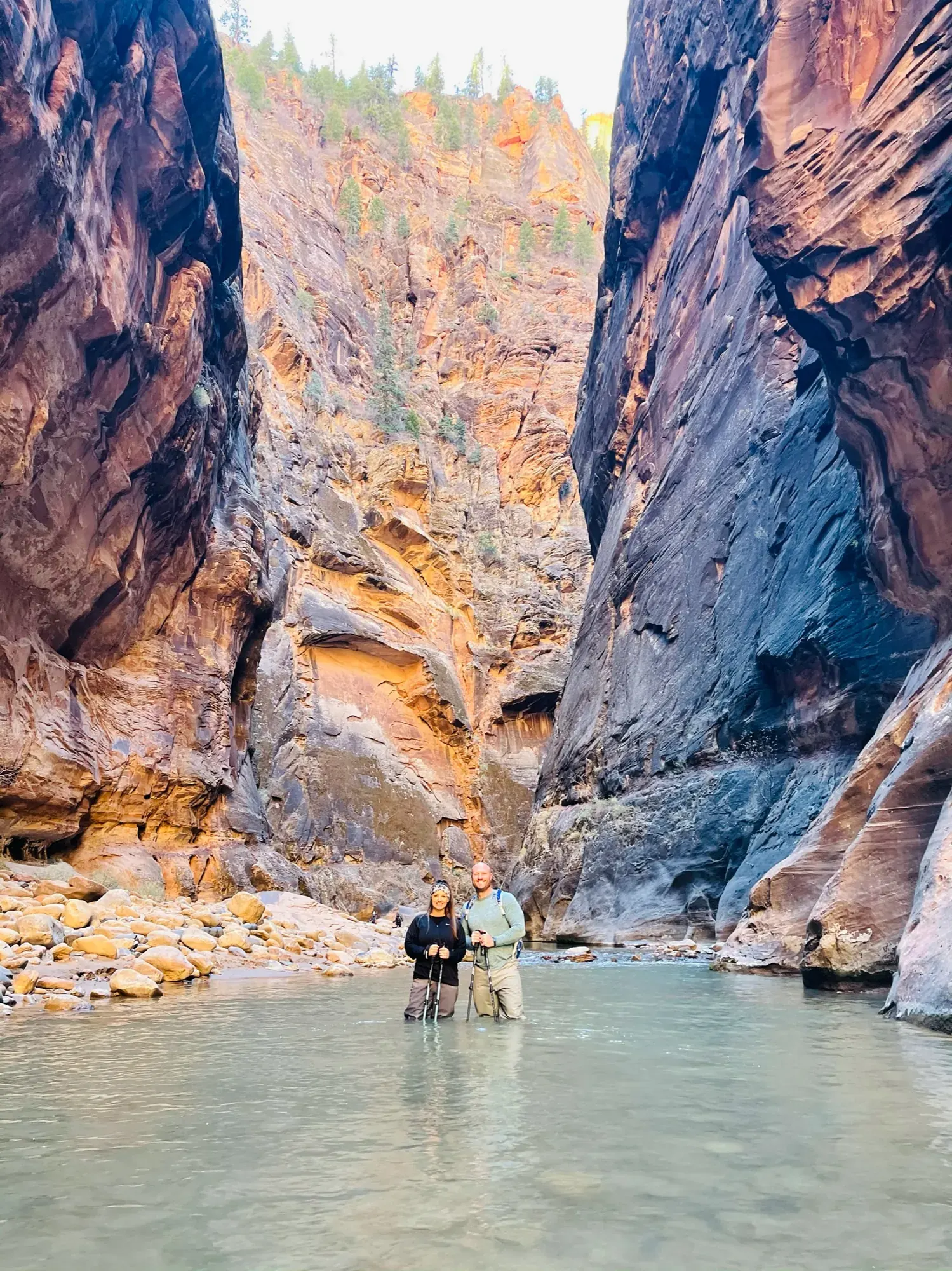
The Narrows (bottom-up)
The bottom-up Narrows route starts at Temple of Sinawava and follows Riverside Walk into the Virgin River. Hikers may turn around earlier or continue upstream as far as Big Spring without a permit.
Zion · Photo: David & Keri New
- 9.4 miDistance
- 1–8 hrTime
- StrenuousDifficulty
Right now
Go with caveats. This is from the last saved check, so confirm current conditions before you go.
- Narrows are Closed. Source
- Watchman Trail closed Source
- Large vehicle restrictions on Zion-Mt. Carmel Highway Source
- Toxic cyanobacteria in rivers, streams, and pools Source
- The Narrows bottom-up: streamflow 164 cfs exceeds NPS 150 cfs closure threshold Source
Updated Nov 19, 5:56 AM ET (NPS alerts, National Weather Service, AirNow and NIFC).
Weather alerts: None returned for the park coordinate. National Weather Service, Nov 19, 5:56 AM ET.
Wildfires within 80 km: 0. NIFC, Nov 19, 5:56 AM ET. A nearby fire doesn’t by itself mean anything in the park is closed.
Air quality: 33 AQI. AirNow, Nov 19, 5:00 AM ET. Preliminary data, subject to change.
The Narrows flow: 164 cfs. USGS, Nov 19, 5:35 AM ET. Lower flow alone doesn’t make the river safe.
Not covered by this check: Road status (unlisted roads unknown); current crowds. Check NPS conditions.
Crowd timing & sources
Current crowd levels: unknown; excluded from the verdict. Historical guidance does not predict today’s queues.
- NPS says parking lots “often fill early in the day.” Use paid Springdale parking and the free town shuttle when needed. NPS timing source
- NPS describes parking as extremely limited. NPS timing source
Research update time unknown. Confirm current operations with NPS.
The numbers, with sources
Distance: Up to 9.4 mi out and back to Big Spring. Source
Time: 1–8 hours. Source
Difficulty: Strenuous. Source
Trailhead: Temple of Sinawava, shuttle stop 9. Source
Route type: out-and-back Source
Built from official sources (checked Nov 3, 2026). Confirm current conditions with the park.
Recreation.gov permits, entrances & campgrounds
Recreation.gov (RIDB). Booking records date not published. NPS guidance above takes precedence. A listing doesn’t mean you need a permit or that there’s space on your dates.
Nearby campground records
Within 10 straight-line miles of the trailhead. Distances are straight-line from map coordinates, not driving distances.
- Lava Point Campground: approximately 8.3 miles straight line. RIDB coordinates · Mapped route source
- WATCHMAN CAMPGROUND: approximately 6.4 miles straight line. RIDB coordinates · Mapped route source
- SOUTH CAMPGROUND (UT): approximately 6.1 miles straight line. RIDB coordinates · Mapped route source
Park campground options (3)
These records belong to the park’s NPS recreation area. We haven’t checked how close these are to the trail, when they open or whether sites are free; check the map and the booking page.
Lava Point Campground — Campground; RIDB reservable: yes. Season: not published in structured RIDB data. Recreation.gov (RIDB) source · Booking details
NPS reservation guidance: Lava Point Campground is open as weather allows, typically May through September. Reservations are required and can be made up to 14 days in advance. First-come, first-served sites are not available. Be sure to make reservations before beginning your trip - cell service is limited in the park. NPS source
WATCHMAN CAMPGROUND — Campground; RIDB reservable: yes. Season: not published in structured RIDB data. Recreation.gov (RIDB) source · Booking details
NPS reservation guidance: Reservations for campsites at Watchman Campground can be made up to six months before your arrival date. Reserve sites online at www.recreation.gov or by calling 877-444-6777. The campground is full nearly every night during the peak season; early reservations are strongly encouraged. NPS source
SOUTH CAMPGROUND (UT) — Campground; RIDB reservable: yes. Season: not published in structured RIDB data. Recreation.gov (RIDB) source · Booking details
NPS reservation guidance: Reservations for campsites at South Campground can be made online at www.recreation.gov or by calling 877-444-6777. Reservations are available up to 14 days in advance. Park campgrounds are full nearly every night during the peak season; early reservations are strongly encouraged. NPS source
Route, junction by junction
Temple of Sinawava → End of Riverside Walk
Begin at Temple of Sinawava beside the restrooms and water-filling station. Follow the paved Riverside Walk for about one mile. At its end, enter the river: this marks the beginning of The Narrows. Source
Distance: About one mile along Riverside Walk. Source
End of Riverside Walk → Orderville Canyon junction
Continue upstream in the Virgin River. NPS describes a riverbed dominated by large slippery boulders, with cold, fast-flowing water. Orderville Canyon is a tributary around two miles up the gorge; NPS calls it a common destination rather than a mandatory stopping point. Source
Junction: Orderville Canyon: The side canyon can be explored only up to its first quarter mile before turning around. The upper canyon is a separate canyoneering trip requiring a permit and entry from the top. Source
Orderville Canyon junction → Big Spring
Continue upstream toward Big Spring if conditions, preparation, and the return allow. NPS describes dozens of seeps, springs, plants, animals, and distinctive formations along the route, rather than a single best viewpoint. Without a permit, you can go upstream from the bottom only as far as Big Spring. Source
No elevation profile: we only draw one from a mapped route we can verify. Route source
In-depth guide
Compiled from linked sources, checked Nov 3, 2026. Each paragraph links to its source.
Decisions & preparation
We show distances for parts of the hike only where the NPS gives them. Source
Turnaround & return planning
Turn back before your group runs low on energy, water or daylight, and leave time for the last shuttle. Planning basis
Parking & transport timing
Riverside Walk starts at the Temple of Sinawava, shuttle stop 9. The Narrows begins where the paved trail ends. The NPS doesn’t say when parking fills. Source
Take the Zion Canyon Line to stop 9, Temple of Sinawava. It’s free, with no ticket, permit or reservation, and buses usually come every 5–10 minutes. From October 25 to November 28, the first bus leaves the visitor center at 7 am, the last at 5 pm, and the last bus leaves Temple of Sinawava at 6:15 pm. Don’t count on that last bus: if it’s full or you miss it, it’s a nine-mile walk to the visitor center. The schedule can change. Shuttle source
What to bring by season
Any season: the NPS Ten Essentials are navigation, sun protection, extra clothing, illumination, first aid, fire supplies where allowed, repair tools, extra food, water and emergency shelter. Tell someone your plan. Source
Warm weather: sun protection, plenty of water and extra food. Cold or wet weather: warm layers, rain gear and extra clothing. River hiking may need more than this; see the water temperatures by season. Source
Summer and early fall are the most popular, when the water is lower and warmest, but life-threatening flash floods are more frequent in monsoon season. Fall weather is steadier, but the days get shorter and the water colder. Winter and early spring usually bring high, cold water, and The Narrows closes in spring when snowmelt pushes the river over 150 CFS. Source
Summer water averages 56° to 68° Fahrenheit (13° to 20° Celsius), so even in shorts bring warm clothes in a dry bag for everyone; parts of the canyon are shady, breezy and cool. Spring and fall water averages 41° to 53° Fahrenheit (5° to 12° Celsius); wear layers, and in early spring and late fall you may need neoprene socks, pants, bib overalls or a wetsuit. Winter water averages 38° to 45° Fahrenheit (3° to 7° Celsius); you may need a neoprene wetsuit or drysuit with warm layers. Ice can form in the canyon in winter, so watch for falling ice and very slippery footing. Source
Children & mobility
The river is the trail. The rocks are slippery and uneven, the water is ankle to chest deep, and the canyon is shaded most of the day, even in summer. Source
Is this hike for you?
From the bottom, you walk the paved Riverside Walk from the Temple of Sinawava, then step into the Virgin River and head upstream. You can turn around whenever you like. Big Spring is as far as you can go without a permit. The river is the trail, the rocks are slippery, and the water runs from ankle to chest deep. Source · Source 2 · Source 3
The NPS advises against river hiking with small children because of strong currents and deep pools. A family can make the dry Riverside Walk the whole trip. Source
Starting from the top at Chamberlain’s Ranch is a different trip: a long one-way hike downstream that needs a permit and its own ride. Overnight top-down trips need a wilderness campsite permit, the maximum stay is one night, and fires aren’t allowed. Source
Getting there: the shuttle
In shuttle season the scenic road is closed to private cars, including before the first bus and after the last one. The ride from the visitor center to the Temple of Sinawava takes about 45 minutes. If you start in Springdale, you walk across the pedestrian footbridge at the entrance to reach the visitor center and the park buses. Source
The buses take wheelchairs, but the river itself isn’t accessible. Pets can’t ride the shuttle. Plan your turnaround around the last bus back, not around daylight. Source
Permits for top-down trips
Top-down day trips use the canyoneering reservation or daily lottery; overnight trips use the separate Narrows overnight reservation system. Pick up your Wilderness permit in person at the Zion Canyon Visitor Center Wilderness Desk. Allow at least 20 minutes and bring your vehicle’s make, model and license plate. Source
The day-trip lottery opens two days before your trip, from midnight to 3 pm Mountain Time, with results around 4 pm. Leftover spaces go first come, first served the day before. This isn’t the same schedule as the Angels Landing lottery. Check current permit terms and fees on the NPS pages before you apply. Source · Source 2
Toxic cyanobacteria
Toxic cyanobacteria grow on the river bottom, rocks, plants and edges, not just as a floating bloom, and their colors and textures vary. Clear water isn’t a sign it’s safe. Don’t drink river water or submerge your head, and read the posted advisory before you go. Source · Source 2 · Source 3
If you think you’ve been exposed and get unexplained symptoms, get medical help right away and call Utah Poison Control at (800) 222-1222. In an emergency, call 911. Source
Rules in the canyon
Above the Orderville Canyon junction, groups are limited to twelve people. A group means everyone affiliated with each other on the same trail or drainage that day (friends, families, clubs, colleagues), so splitting up doesn’t get around it. Source
Stay in the river to protect the banks, but in a flood warning get to high ground. Pack out all food scraps (apple cores, fruit peels, nut shells) plus toilet paper, human waste and hygiene products. Keep food in a hard-sided container or an interlocking wire-mesh bag hung out of wildlife’s reach. Inflatable tubes are banned on park rivers; kayaks and other boats count as a separate river trip. Source
Before you go
Check the weather and flash-flood potential the day you go. Bring closed-toe footwear, a support pole, warm layers in a dry bag, more food than you think you need, drinking water, a real headlamp and waste bags, and set a time to turn back. Stop walking before you look around or take photos; the rocks underfoot are hard to see. Source · Source 2
Sources & planning limits
Reviewed 2026-11-03. Check current conditions for your trip dates.
- The NPS gives distances and times for different start and end points. We haven’t matched them to one measured route. Source
- Check access, shuttles and services with the NPS for your date. Source
- Check the linked NPS pages for anything specific to your trip. Source
- Check current permit, reservation and fee terms with the NPS for your date. Source
Getting there and back
Reach Riverside Walk at Temple of Sinawava, shuttle stop 9; the Narrows begins at the paved trail’s end. Source
Shuttle: At Temple of Sinawava, use Zion Canyon Line stop 9. The service is free and requires no ticket, permit, or reservation; buses generally arrive every 5–10 minutes. For October 25–November 28, the posted first visitor-center departure is 7 am, last visitor-center departure 5 pm, and last departure from Temple of Sinawava 6:15 pm. Do not wait for that final bus: NPS warns that a full or missed last shuttle can mean a nine-mile walk to the visitor center. The schedule is subject to change. Source
Return: Turn around before feeling tired so that enough energy remains to finish by the same route. Return downstream through the river and along Riverside Walk to Temple of Sinawava; there is no separate bottom-up exit route. Source
Water
Water filling and restrooms at Temple of Sinawava; there are no bathrooms on the hike. Bring human waste disposal bags. Source
Never drink from rivers or streams; recreational filtration methods are not effective at reducing cyanotoxins to safe levels . Drinking water is available at visitor centers, campgrounds, and the Temple of Sinawava. Carry enough water, one gallon per person per day, and drink it. If you plan to refill your water in The Narrows, collect drinking water directly from springs and filter, disinfect, or otherwise treat it as you would in the backcountry. Water flow at natural springs can vary — check for information at the Zion Canyon Visitor Center Wilderness Desk. Source
The trailhead has a water-filling station beside the restrooms. Use these facilities before entering the canyon; the hike has no bathrooms. Source
Hazards
Flash floods
Flash floods, often caused by storms miles away, are a very real danger and can be life threatening. During a flash flood, the water level rises quickly, within minutes or even seconds. A flash flood can rush down a canyon in a wall of water 12 feet high or more. Before starting any trip into a narrow canyon, speak with a park ranger at a visitor center or read online about current conditions , weather forecasts , and flash flood potential . If bad weather threatens your area, do not enter narrow canyons. Source
Warning signs of flooding
Continuously evaluate weather conditions and watch for these indications of a possible flash flood: Any deterioration in weather conditions Buildup of clouds or sounds of thunder Sudden changes in water clarity from clear to muddy Floating debris, such as branches Audible roar of water up-canyon If you observe any of these signs, seek higher ground immediately. Climbing even a few feet higher may save your life. Remain on high ground until conditions improve — water levels usually drop within 24 hours. The Virgin River Narrows are closed when the National Weather Service issues a Flash Flood Warning. Source
Slippery footing and lower-leg injuries
Lower leg fractures are among the most common injuries suffered in the Wilderness. The most common cause of lower leg injuries is jumping from rocks. Do not jump from any height – lower yourself down slowly or find an easier way around. Attention and balance are a must for a safe trip through The Narrows. Always pay attention to where you are walking, and come to a complete stop before looking around. If a member of your party does not have good balance, you may want to consider a different hike. Source
Hypothermia
Hypothermia occurs when the body is cooled to dangerous levels. It is the number one killer of outdoor recreationists , even in summer. Hypothermia usually happens without the victim’s awareness. It is a greater hazard in narrow canyons, because immersion in water is the quickest way to cool the body. To prevent hypothermia, avoid cotton clothing (it provides no insulation when wet) and eat high-energy food before you are chilled. Signs of hypothermia include: Uncontrollable shivering Stumbling and poor coordination Fatigue and weakness Confusion or slurred speech If you recognize any of these signs, stop hiking and immediately replace wet clothing with dry clothing . Warm the victim with your own body and a warm drink, and shelter the individual from breezes. A pre-warmed sleeping bag will also help prevent further heat loss. Source
Heat exhaustion
Heat exhaustion often occurs when the body loses more fluid than it takes in. Signs of heat exhaustion include nausea, vomiting, fatigue, headaches, pale appearance, stomach cramps, and cool clammy skin. If a member of your party begins to experience any of these symptoms, stop your hike immediately . Find a cool, shady area and rest with your feet up to distribute fluids throughout your body. It is important to drink fluids, but it is also important to eat . Drinking lots of fluids and not eating, while suffering from heat exhaustion, can lead to a potentially dangerous condition of low blood salt. If heat exhaustion symptoms persist for more than two hours, seek medical help. Source
Season
Most visitors go in summer and early fall. The Narrows closes above 150 CFS and when the National Weather Service issues a Flash Flood Warning. Source
Summer and Fall Most people hike The Narrows in the summer and early fall when the water level drops and tends to be at its warmest. However, keep in mind that life-threatening flash floods are more frequent during the monsoon season. Fall brings more stable weather, but the days get shorter and the water temperature drops. Read more about Zion’s Weather and Climate here . Winter and Spring Winter and early spring commonly bring high water levels and cold water. The Narrows will be closed during the spring when snowmelt raises the river over 150 CFS. Source
Summer Even in mid-summer, the temperature of the river can be cool. Average summer water temperatures range from 56° to 68° Fahrenheit (13° to 20° Celsius). Although you’ll probably hike in shorts and a short-sleeve shirt, bring extra warm clothing in a dry bag for each member of your group. Parts of the canyon are quite shady, breezy, and cool. Spring and Fall Hike with multiple layers that can be removed or added as the air temperature changes. In the early spring and late fall months, neoprene socks, pants, bib overalls, or a wetsuit may be necessary to hike in the river. Average spring and fall water temperatures range from 41° to 53° Fahrenheit (5° to 12° Celsius). Winter A neoprene wetsuit or drysuit with warm layers may be needed. Average winter water temperatures range from 38° to 45° Fahrenheit (3° to 7° Celsius). During the winter months, ice may form within the canyon. Watch for falling ice and be prepared for very slippery conditions. Source
Gear & rules
Pets are not allowed. Source
Upstream travel in Orderville Canyon stops after the first quarter mile; the upper canyon requires a canyoneering permit and entry from the top. Source
Filling a gap in your kit? Compare these packing essentials on Amazon. Choose gear for your route, conditions and the park’s guidance.
As an Amazon Associate we earn from qualifying purchases. How this works
Hiking in the Virgin River is like walking on slippery bowling balls. Much of the hike requires balancing on algae-coated rocks in the middle of a swiftly flowing river. Sturdy, closed-toe footwear is essential. Hiking boots with good ankle support are best. Sandals, crocs, and bare feet are not appropriate. Inappropriate footwear often results in twisted ankles and crushed toes. Source
The temperature of the water in the Virgin River is often colder than the air. At the same time, breezes blow steadily, and very little sunlight penetrates to the canyon floor. Regardless of the time of year, always take additional warm clothing stored in a dry waterproof bag . Clothing made of wool or synthetic fibers has the best insulation. Source
Hiking/trekking poles or sticks are highly recommended and will help you maintain balance . It is often difficult to balance without the support of a pole. Poles/sticks can also be used to check water depth when the river is cloudy with sediments. Source
Water levels in the Virgin River Narrows, even when the flow is low, can range from ankle deep to full swims. Most of the time, the river is ankle to knee-deep, but all top-down hikers should be prepared for deep sections where swimming is required. Even the most experienced hikers occasionally trip or fall in the Virgin River. It is a good idea to keep your belongings in waterproof bags/containers. Many hikers bring or rent dry bags to protect all of their gear. Smaller, resealable bags provide extra protection for phones, cameras, wallets, keys, and other valuables. Source
Food keeps your energy up and helps you stay warm. Always bring more food than you plan to eat. It can be a life-saver if you spend an unexpected evening or night in The Narrows. Source
Even a minor injury can cause major problems in Zion Wilderness. Be sure to bring basic first aid supplies for you and your group. Flashlight / Headlamp Every week, hikers and canyoneers spend unintended nights in the Wilderness of the park. A good headlamp can mean the difference between getting back to the trailhead and spending the night in the canyon. The flashlight on a phone is not sufficient for nighttime navigation. Waste Disposal Bags Human waste, toilet paper, and hygiene products must be carried out of all Wilderness areas and narrow canyons. Wilderness permit groups must carry a minimum of one human waste disposal bag per person while in the wilderness. There are no toilets in The Narrows. Use the toilets at the Temple of Sinawava before starting your hike. Source
Pets are not allowed. The park neither sells nor rents equipment; nearby private businesses offer rental equipment. Source
Pace
NPS lists a 1–8-hour duration and advises turning around before becoming tired. There is no formal destination that every visitor must reach. Source
Questions
Do I need a permit for the bottom-up hike?
No permit is required to hike upstream as far as Big Spring. The approximately 16-mile top-down trip is a separate wilderness-permit itinerary. Source
Must I reach Big Spring?
No. There is no single best spot or viewpoint. NPS encourages a hike lasting a few minutes or a few hours followed by a return to the trailhead. Source
How far can I go into Orderville Canyon?
Only the first quarter mile upstream before returning. Exploring the upper canyon requires a canyoneering permit and entry from the top. Source
Can a filter make river water safe to drink?
NPS says never to drink rivers or streams because recreational filtration does not reduce cyanotoxins to safe levels. Collect directly from springs if refilling, then treat that spring water; ask the wilderness desk about variable spring flow. Source
Can I rent gear from the park?
No. Zion National Park does not sell or rent gear. NPS directs visitors who lack equipment to private businesses in the area. Source
Alternatives
Riverside Walk: The paved one-mile approach is described as easy; turn back before entering the river. Source
More Zion trail guides
- Angels Landing5.4 mi · Strenuous
- Canyon Overlook Trail1 mi · Moderate
- Pa’rus Trail1.6 mi one way · Easy
- Riverside Walk1 mi one way · Easy
- Taylor Creek2.6 mi one way · Moderate
- Timber Creek Overlook0.6 mi one way · Easy
- Upper Emerald Pools1 mi · Moderate
- Watchman Trail3.3 mi · Moderate