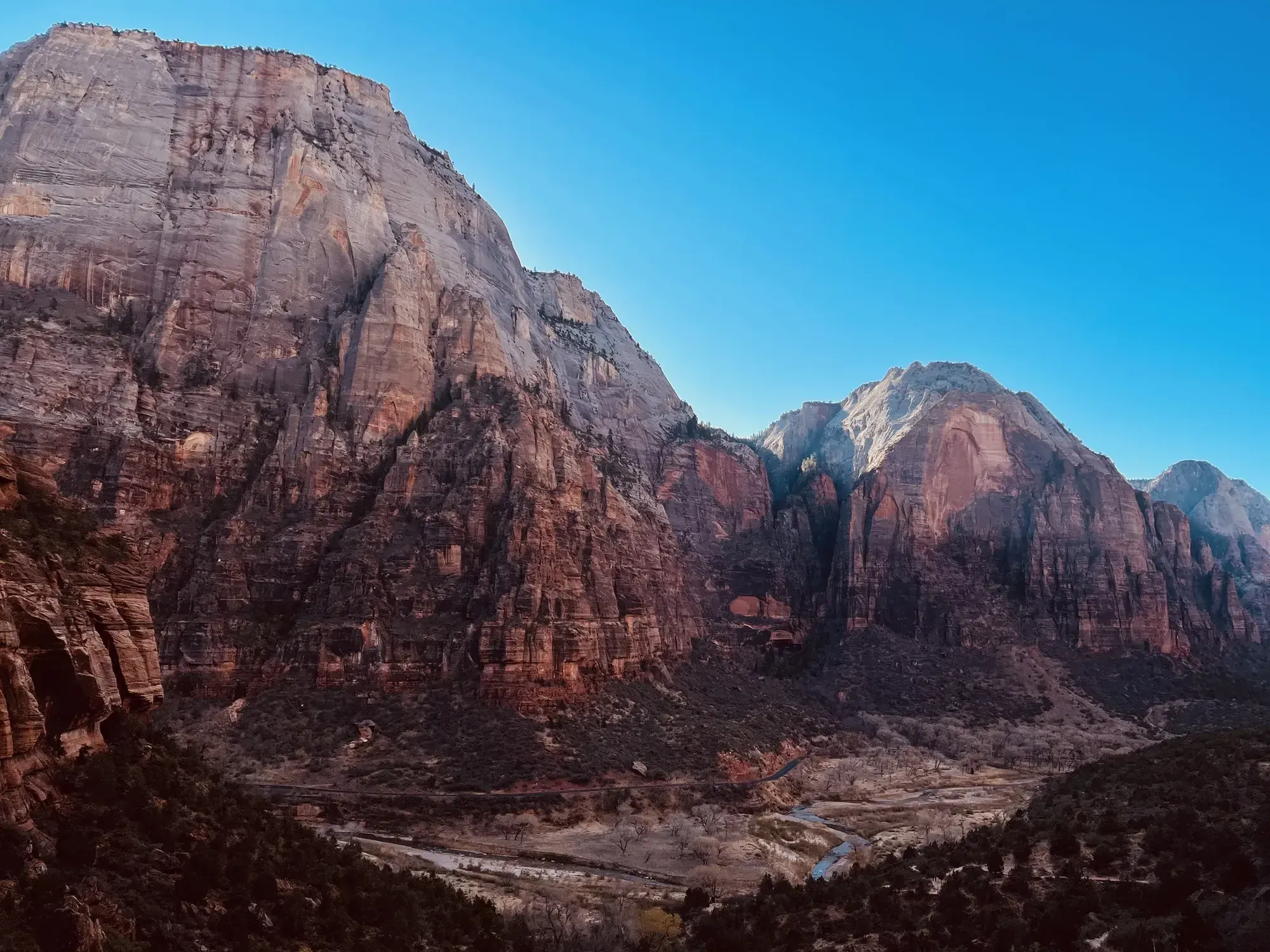
Canyon Overlook Trail
Long drop-offs, mostly fenced. Rocky and uneven trail ends at a viewpoint for Pine Creek Canyon and lower Zion Canyon. To enter or exit the parking area just east of the tunnel, you must turn right. Parking is extremely limited, be prepared to try multiple times. Pit toilets are available in the parking area.
Zion · Photo: David & Keri New
- 1 miDistance
- 2 ftElevation gain
- 1–2 hrTime
- ModerateDifficulty
The numbers, with sources
Distance: 1 mile total. The NPS trail survey says 0.5 miles one way. Source
Gain: 154.2 feet gain and 48.5 feet loss in measured direction. Source
Time: 1–2 hours Source
Difficulty: Moderate Source
Trailhead: Canyon Overlook Trailhead is located on the East Side of Zion. Follow State Route 9 through the Zion-Mount Carmel Tunnel to the trailhead. Parking is limited. Source
Route type: out-and-back Source
Built from official sources (checked Nov 3, 2026). Confirm current conditions with the park.
Recreation.gov permits, entrances & campgrounds
Recreation.gov (RIDB). Booking records date not published. NPS guidance above takes precedence. A listing doesn’t mean you need a permit or that there’s space on your dates.
Nearby campground records
Within 10 straight-line miles of the trailhead. Distances are straight-line from map coordinates, not driving distances.
- WATCHMAN CAMPGROUND: approximately 2.7 miles straight line. RIDB coordinates · Mapped route source
- SOUTH CAMPGROUND (UT): approximately 2.6 miles straight line. RIDB coordinates · Mapped route source
Park campground options (3)
These records belong to the park’s NPS recreation area. We haven’t checked how close these are to the trail, when they open or whether sites are free; check the map and the booking page.
Lava Point Campground — Campground; RIDB reservable: yes. Season: not published in structured RIDB data. Recreation.gov (RIDB) source · Booking details
NPS reservation guidance: Lava Point Campground is open as weather allows, typically May through September. Reservations are required and can be made up to 14 days in advance. First-come, first-served sites are not available. Be sure to make reservations before beginning your trip - cell service is limited in the park. NPS source
WATCHMAN CAMPGROUND — Campground; RIDB reservable: yes. Season: not published in structured RIDB data. Recreation.gov (RIDB) source · Booking details
NPS reservation guidance: Reservations for campsites at Watchman Campground can be made up to six months before your arrival date. Reserve sites online at www.recreation.gov or by calling 877-444-6777. The campground is full nearly every night during the peak season; early reservations are strongly encouraged. NPS source
SOUTH CAMPGROUND (UT) — Campground; RIDB reservable: yes. Season: not published in structured RIDB data. Recreation.gov (RIDB) source · Booking details
NPS reservation guidance: Reservations for campsites at South Campground can be made online at www.recreation.gov or by calling 877-444-6777. Reservations are available up to 14 days in advance. Park campgrounds are full nearly every night during the peak season; early reservations are strongly encouraged. NPS source
Route, junction by junction
East-side trailhead → sandstone steps
Start at the signed trail by the very small parking area. Climb the sandstone steps and follow the rocky path above the slot canyon. Source
Rocky traverse → fenced overlook
The overlook is 0.5 mile one way. Stay on the trail through the narrow, stepped sections and under low rock overhangs. Source
Fenced overlook → trailhead
Turn around at the fenced cliff edge and come back the same way, 1 mile in all. It’s a viewpoint, not a trail down into the canyon. Source
No elevation profile: we only draw one from a mapped route we can verify. Route source
In-depth guide
Compiled from linked sources, checked Nov 3, 2026. Each paragraph links to its source.
Decisions & preparation
We only show distances between points where the NPS publishes them. We don’t split the total into made-up segments. Source
Turnaround & return planning
Turn back early if the group is running low on energy, water or daylight. Planning basis
Parking & transport timing
The trailhead is on Zion’s east side. Take State Route 9 through the Zion-Mount Carmel Tunnel. Parking is limited, and the NPS doesn’t say when it fills. Source
What to bring by season
Any season: the NPS Ten Essentials (navigation, sun protection, extra clothing, a light, first aid, fire supplies where allowed, repair tools, extra food, water and emergency shelter). Tell someone your route and when you’ll be back. Source
Warm weather: sun protection, plenty of water and extra food. Cold or wet weather: warm layers and rain gear, plus an extra layer in case you’re out longer than planned. Source
Children & mobility
NPS trail survey. Length (one way): 0.5 mi (0.8 km). Elevation: gain 154.2 ft (47.0 m), loss 48.5 ft (14.78 m). Grade: typical 7.6%, maximum 50.4%; 23.9% of the trail is at 10% or steeper. Cross slope: typical 4.9%, maximum 36.4%. Tread width: typical 48 in (122.4 cm), minimum 12 in (30.5 cm). Surface: 73.8% hard rock, 18.0% firm soil, 8.2% soft sand. Obstructions: 118.9 ft (36.2 m) of overhanging rock with an average clearance of 7 ft (2.1 m), a minimum of 4 ft (1.2 m) and 30 in (76.2 cm) of tread left; staircases with steps up to 18 in (45.7 cm) tall and 0 in of tread left; boulders up to 12 in (30.5 cm) tall and 0 in of tread left. Last surveyed February 20, 2025. Obstructions under 4 in (10.2 cm), or outside a tread area 36 in (91.4 cm) wide by 96 in (243.8 cm) high, weren’t recorded. Source
Is this hike for you?
Canyon Overlook is a short, rocky trail on Zion’s east side, just past the Zion–Mount Carmel Tunnel. The NPS rates it moderate and lists it as 1 mile (1.6 km) total, 0.5 miles each way, taking 1-2 hours. It ends at a fenced cliff edge looking down main Zion Canyon toward the Towers of the Virgin. Expect steps, narrow sections and long drop-offs, and not every exposed spot is fenced. Source
The trail
You start up a series of sandstone steps with a metal handrail, then cross rocky ground above a dark slot canyon. Near the end the view opens onto red and cream-colored slickrock. Watch for bighorn sheep. Stay on the trail and behind the barriers at the cliff edge, and give other hikers room to pass in the narrow spots. You come back the same way. Source
In the direction the NPS measured it, the trail gains 154.2 feet and loses 48.5 feet. Source
Getting to the trailhead
Take State Route 9 east through the Zion-Mount Carmel Tunnel to the trailhead. Parking is extremely limited, so be ready to try more than once. The NPS says you have to turn right both into and out of the parking area just east of the tunnel. Don’t make up your own parking along the tunnel approach. Source
Permits and fees
No reservation is needed for this hike. Check the NPS fees page for the park entrance fee; we don’t list a price here. Source · Source 2
Water and restrooms
There are pit toilets in the parking area. The NPS doesn’t list drinking water, so bring what you need for the round trip. Source
Kids, strollers and wheelchairs
This isn’t a stroller or wheelchair trail. The NPS survey (last done February 20, 2025) found grades up to 50.4%, a tread as narrow as 12 inches, staircases with steps up to 18 inches tall, boulders, and overhanging rock as low as 4 feet. Most of the trail is hard rock, with some firm soil and soft sand. The NPS gives no minimum age; with kids, the drop-offs and steps matter more than the distance. The full survey numbers are in the trip plan. Source
Before you go
The NPS lists the hike for Winter, Spring, Summer and Fall. Check the forecast and current alerts before you go, and pick another hike if the trail is closed. Source
When we checked, the park had three alerts that matter here. Oversize vehicles (over the length, width, height or weight limits) can’t drive between Canyon Junction and the park’s East Entrance. Toxic cyanobacteria are in Zion’s rivers, streams and pools, so don’t drink the water or put your head under. And once Zion’s parking is full, park in Springdale; cars outside designated spaces can be ticketed and towed. Source
The NPS doesn’t publish a pet rule for this trail, so check the park’s pet rules before you bring a dog. Source
Elevation profile
There’s no elevation profile yet: the NPS trail map line comes from its trail data and USGS 3DEP terrain, but we haven’t verified complete measurements for this route. Source · Source 2 · Source 3 · Source 4
Sources & planning limits
Reviewed 2026-11-03. Check current conditions for your trip dates.
- NPS alert, November 3, 2026: oversize vehicles can’t travel the Zion-Mt. Carmel Highway between Canyon Junction and the East Entrance. Check current alerts before you go. Source
- NPS alert, November 3, 2026: toxic cyanobacteria in rivers, streams and pools. Don’t drink the water or put your head under anywhere in Zion National Park. Source
- NPS alert, November 3, 2026: Zion has limited parking. When it’s full, park in Springdale. Cars outside designated spaces can be ticketed and towed. Source
- No elevation profile yet: we haven’t verified complete measurements for this route. Source
- NPS details are as of the date shown. Confirm access, services and reservations for your travel date. Source
Getting there and back
Canyon Overlook Trailhead is located on the East Side of Zion. Follow State Route 9 through the Zion-Mount Carmel Tunnel to the trailhead. Parking is limited. Source
Return: Come back the way described above. Return along the same trail unless a separate transport plan has been confirmed. Source
Water
Pit toilets are available in the parking area. Source
Hazards
Lengt h (one way) | 0.5 mi (0.8 km) Elevation | Gain: 154.2 ft (47.0 m) | Loss: 48.5 ft (14.78 m) Grade | Typical: 7.6% | Maximum: 50.4% | 23.9% of the trail is at a 10% or higher grade. Cross Slope | Typical: 4.9% | Maximum: 36.4% Tread Width | Typical: 48 in (122.4 cm) | Minimum: 12 in (30.5 cm) Surface | 73.8% of the trail is hard rock, 18.0% is firm soil, and 8.2% is soft sand Obstructions | 118.9 ft (36.2 m) of o verhanging rocks with an a verage vertical clearance of 7ft (2.1 m), minimum vertical clearance of 4 ft (1.2 m), and 30 in (76.2 cm) of remaining tread. | Staircases with steps up to 18 in (45.7 cm) tall and 0 in of remaining tread | Boulders up to 12 in (30.5 cm) tall and 0 in of remaining tread Last assessed February 20, 2025. Obstructions less than 4 in (10.2 cm) or outside of the tread area 36 in (91.4 cm) wide by 96 in (243.8 cm) high were not reported. Source
Season
Use current official conditions; activity season labels are not a guarantee of access. Source
Current trail conditions require a trip-date check. Source
Gear & rules
Follow current signs and closures, and treat any side trip as a separate decision. Source
Filling a gap in your kit? Compare these packing essentials on Amazon. Choose gear for your route, conditions and the park’s guidance.
As an Amazon Associate we earn from qualifying purchases. How this works
The NPS doesn’t publish a pet rule for this exact route. Confirm the applicable rule before bringing an animal. Source
Questions
Which route do these figures describe?
1 mile total. The NPS trail survey says 0.5 miles one way. Canyon Overlook is reached from Zion’s east side near the Zion–Mount Carmel Tunnel. It is a short but rocky walk with steps, narrow sections and long drop-offs. Most fencing does not mean every exposed section is enclosed. The endpoint is a fenced viewpoint toward lower Zion Canyon. Source
Is the trail open right now?
No. NPS details as of Nov 3, 2026. Confirm current conditions and closures with NPS. Source
Is there a measured elevation profile?
Official NPS trail geometry sampled with USGS 3DEP terrain; no mileage or gain scaling. NPS publishes 0.50 mi one way; the traced line measures 0.48 mi. The difference is unresolved. Source
Alternatives
Parking is extremely limited. NPS says entry and exit at the parking area just east of the tunnel require a right turn. This is an access constraint, not a recommended roadside turnaround maneuver. If space is unavailable, be prepared to try again later rather than improvising parking along the tunnel approach. Source
Camp near Canyon Overlook Trail
Closest campgrounds by drive time to Canyon Overlook Trailhead:
- 17 min Watchman (6.2 mi, in the park)
- 17 min South (6.3 mi, in the park)
- 56 min Ponderosa Grove Campground ↗ (32.6 mi, Bureau of Land Management)
- 1 hr 13 min Red Cliffs Campground ↗ (41 mi, Bureau of Land Management)
- 1 hr 24 min Duck Creek ↗ (52.7 mi, USDA Forest Service)
Driving time with no traffic (OSRM, OpenStreetMap roads). Some park roads are shuttle-only in season. All camping near Zion
More Zion trail guides
- Angels Landing5.4 mi · Strenuous
- Pa’rus Trail1.6 mi one way · Easy
- Riverside Walk1 mi one way · Easy
- Taylor Creek2.6 mi one way · Moderate
- The Narrows (bottom-up)9.4 mi · Strenuous
- Timber Creek Overlook0.6 mi one way · Easy
- Upper Emerald Pools1 mi · Moderate
- Watchman Trail3.3 mi · Moderate