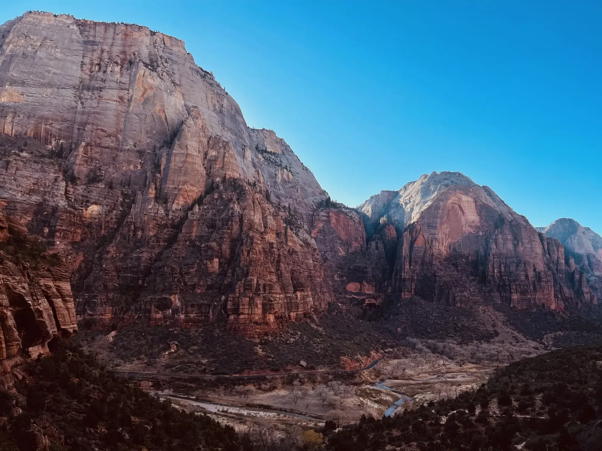
Angels Landing
Angels Landing follows a steep, narrow ridge above Zion Canyon. A permit is required to continue beyond Scout Lookout.
Permit required
Zion · Photo: David & Keri New
- 5.4 miDistance
- 1,488 ftElevation gain
- 4 hrTime
- StrenuousDifficulty
The numbers, with sources
Distance: 5.4 mi round trip. Source
Gain: 1,488 ft for the full hike. Source
Time: Most hikers take around 4 hours; some take longer. Source
Difficulty: Strenuous, challenging. Source
Trailhead: Kayenta & West Rim Trailhead at The Grotto, shuttle stop 6. Source
Route type: out-and-back Source
Built from official sources (checked Nov 3, 2026). Confirm current conditions with the park.
Recreation.gov permits, entrances & campgrounds
Recreation.gov (RIDB). Booking records date not published. NPS guidance above takes precedence. A listing doesn’t mean you need a permit or that there’s space on your dates.
Nearby campground records
Within 10 straight-line miles of the trailhead. Distances are straight-line from map coordinates, not driving distances.
- Lava Point Campground: approximately 9.7 miles straight line. RIDB coordinates · Mapped route source
- WATCHMAN CAMPGROUND: approximately 4.6 miles straight line. RIDB coordinates · Mapped route source
- SOUTH CAMPGROUND (UT): approximately 4.4 miles straight line. RIDB coordinates · Mapped route source
Matched permits & entrances (4)
Angels Landing: Fall (Hikes on September 1 – November 30) — Permit; RIDB reservable: yes. Season: not published in structured RIDB data. Recreation.gov (RIDB) source · Booking details
Angels Landing: Winter (Hikes on December 1 - February 28) — Permit; RIDB reservable: yes. Season: not published in structured RIDB data. Recreation.gov (RIDB) source · Booking details
Angels Landing: Summer (Hikes on June 1 – August 31) — Permit; RIDB reservable: yes. Season: not published in structured RIDB data. Recreation.gov (RIDB) source · Booking details
Angels Landing: Spring (Hikes on March 1 -- May 31) — Permit; RIDB reservable: yes. Season: not published in structured RIDB data. Recreation.gov (RIDB) source · Booking details
Park campground options (3)
These records belong to the park’s NPS recreation area. We haven’t checked how close these are to the trail, when they open or whether sites are free; check the map and the booking page.
Lava Point Campground — Campground; RIDB reservable: yes. Season: not published in structured RIDB data. Recreation.gov (RIDB) source · Booking details
NPS reservation guidance: Lava Point Campground is open as weather allows, typically May through September. Reservations are required and can be made up to 14 days in advance. First-come, first-served sites are not available. Be sure to make reservations before beginning your trip - cell service is limited in the park. NPS source
WATCHMAN CAMPGROUND — Campground; RIDB reservable: yes. Season: not published in structured RIDB data. Recreation.gov (RIDB) source · Booking details
NPS reservation guidance: Reservations for campsites at Watchman Campground can be made up to six months before your arrival date. Reserve sites online at www.recreation.gov or by calling 877-444-6777. The campground is full nearly every night during the peak season; early reservations are strongly encouraged. NPS source
SOUTH CAMPGROUND (UT) — Campground; RIDB reservable: yes. Season: not published in structured RIDB data. Recreation.gov (RIDB) source · Booking details
NPS reservation guidance: Reservations for campsites at South Campground can be made online at www.recreation.gov or by calling 877-444-6777. Reservations are available up to 14 days in advance. Park campgrounds are full nearly every night during the peak season; early reservations are strongly encouraged. NPS source
Route, junction by junction
The Grotto → Refrigerator Canyon
From The Grotto, cross the road and the Virgin River bridge to begin the West Rim Trail. The route climbs steep switchbacks against the canyon wall before flattening as it enters Refrigerator Canyon. NPS describes this flatter stretch as relief from the preceding heat and elevation gain. Source
Refrigerator Canyon → Scout Lookout
The climb resumes at Walter’s Wiggles, a sequence of 21 switchbacks. These lead to Scout Lookout, a relatively flat, sandy area with some shade. The lookout offers views of Zion Canyon and a place to look for California condors along the cliffs. Source
Junction: Scout Lookout: The West Rim Trail meets the route to Angels Landing here. Continuing to Angels Landing requires a permit; many visitors stop at the lookout. Source
Scout Lookout → Angels Landing
The Angels Landing route follows a steep, narrow ridge with uneven steps cut into the rock. Chains are anchored intermittently, rather than continuously, along the route. Some stretches are only a few feet wide, with exposed edges and drop-offs as great as 1,000 feet on either side. At the destination the trail widens slightly, with room to rest and take in Zion Canyon. Source
Distance: 0.5 mile on the Angels Landing Trail, as listed on the NPS activity page. Source
Time: NPS lists 1–2 hours for the Angels Landing Trail only; this excludes the West Rim approach to Scout Lookout. Source
History
The NPS trail inventory dates construction of Angels Landing Trail to 1926, following completion of the West Rim Trail that provided access to Scout Lookout. Source
The inventory describes the initial footholds as chiseled by hand on the spine of a steep-sided sandstone cliff. It records an erosion-control stabilization program completed by Civilian Conservation Corps personnel in March 1934. Source
No elevation profile: we only draw one from a mapped route we can verify. Route source
In-depth guide
Compiled from linked sources, checked Nov 3, 2026. Each paragraph links to its source.
Decisions & preparation
We only show a leg’s distance when the NPS publishes it. We don’t split the total into made-up pieces. Source
Turnaround & return planning
Turn back before the group runs low on energy, water or daylight; Scout Lookout is a good place to stop. Don’t count on a pickup or a shortcut down. Planning basis
Parking & transport timing
Take the Zion Canyon shuttle to The Grotto when it’s running. In the winter and spring weeks without shuttle service, drive to the trailhead and park on pavement. The NPS doesn’t say when parking fills. Source
Ride the Zion Canyon Line to The Grotto (stop 6 on the trail page). Shuttles are free, need no ticket or reservation, and usually come every 5–10 minutes. For October 25–November 28 the posted schedule has the first visitor center departure at 7 am, the last at 5 pm, and the last departure from Temple of Sinawava at 6:15 pm. That last time is for stop 9, not The Grotto. Don’t wait for the last bus, and the schedule can change. Shuttle source
What to bring by season
All seasons: the NPS Ten Essentials (navigation, sun protection, extra clothing, a light, first aid, fire supplies where allowed, repair tools, extra food, water and emergency shelter). Leave your plan and return time with someone. Source
Hot weather: sun protection, plenty of water and extra food. Cold or wet weather: warm layers and rain gear, plus extra clothing in case you’re out longer than planned. Source
Listed as year-round. You still need the permit and decent conditions. Source
Most of the year you reach the trailhead by shuttle. In the few winter and spring weeks without service, you drive. Source
Children & mobility
The trail is unpaved, rocky and less than 3 ft (1 m) wide in many places. Chains serve as handrails in several sections, with long drop-offs, and hikers pass in both directions in tight space. Source
NPS accessibility survey of the trail to Scout Lookout, last assessed March 10, 2025: 1.9 mi (3 km) one way, 1187 ft (361.8 m) of gain and 63 ft (19.2 m) of loss. Grade is typically 12.9% and up to 43%, and 67% of the trail is at 8.3% or steeper. Cross slope is typically 3.7%, up to 18.7%. Tread is typically 63 in (159.2 cm) wide, at least 21 in (53.3 cm). Surface: 81.1% hard concrete, 17.3% concrete covered in firm soil and 1.7% soft sand. Overhanging rocks run 173.4 ft (52.9 m) with 7 ft (2.1 m) of clearance and 45 in (114.3 cm) of tread left. Steps are up to 6 in (15.2 cm) tall with 0 in of tread left. The survey skipped obstacles under 4 in (10.2 cm) tall or outside a tread area 15 in (38.1 cm) wide by 96 in (243.8 cm) high. Source
Is this hike for you?
Angels Landing is 5.4 miles round trip from The Grotto. The last stretch past Scout Lookout follows a steep, narrow ridge with chains and drop-offs, and you need a permit for it. The park asks you not to go up if you have any fear of heights. A permit gets you onto the ridge; it doesn’t decide whether the climb suits you. Source
Scout Lookout works as a destination for the whole group, even if only some of you have permits or someone doesn’t want the ridge. Agree on where and when to meet before anyone goes on, because most people can’t get a phone signal in Zion Canyon. You can also keep going on the West Rim Trail for views above Angels Landing without the chains, if you have the time and supplies. Source
The trail
From The Grotto the West Rim Trail climbs switchbacks against the canyon wall, flattens out in Refrigerator Canyon, then climbs again up Walter’s Wiggles to Scout Lookout. The step-by-step route and the NPS accessibility survey are in the plan below. The NPS gives distances for different pieces of the route, so keep each figure with the part it describes. Source · Source 2
Permits and entry
You don’t need a reservation to enter the park, and the shuttle needs no permit or reservation. Angels Landing does need a permit. In the seasonal lottery you can rank seven days and times, including ranges of dates and times. Canceled seasonal permits go into the day-before lottery, so don’t count on picking up a cancellation on the spot. Source
Camping overnight, say on a longer West Rim Trail trip, needs a separate Wilderness permit, and groups on Zion Wilderness trails are limited to twelve people. Source
Getting to the trailhead
During shuttle season the scenic drive is closed to private cars before the first bus and after the last, so an early start still means the shuttle. Lots in the park often fill early, and a permit doesn’t hold a space. You can also park (paid) in Springdale, ride the Springdale shuttle to Zion Canyon Village, walk across the pedestrian footbridge to the visitor center and catch the canyon shuttle there. Source · Source 2
If you’re staying at Zion Lodge, your reservation access code gets you into guest parking. From there, walk or take the shuttle up the canyon. Source
Plan to be back well before the last bus: the park warns that rangers can’t give you a ride if you miss it. Eating and smoking aren’t allowed on the shuttle, and drinks need to be in capped water bottles. Source
Weather, rockfall and emergencies
Don’t go up on wet or icy rock, with storm clouds nearby, or if you’ll still be on the trail at dark. Shaded rock can stay wet after a dry forecast. In winter the chains get very cold, and the park suggests gloves. Source
Rockfall can happen any time, especially near cliffs. If it does, move quickly away from the cliff. If you can’t, shelter behind the largest boulder nearby with your pack over your head, and move away once the rocks stop. Source
In an emergency, try 911; a call that connects reaches Zion Dispatch. If you have no service, find a ranger or park volunteer on the trail or at a trailhead. Source
Water and food
The park recommends a gallon of water per person per day in Zion. There’s no drinkable water along the Angels Landing route, so carry it all from the start. Source
Don’t leave packs alone, including at the base of the chains, because wildlife will get into them. Secure water bottles and hats so they don’t fall or blow away. There are no trash cans on the trail, so carry out everything, food scraps included. Source
On the trail
Don’t throw or roll rocks or build cairns: nesting birds and rock climbers can be below you. Keep your voice down and use headphones for music. Don’t mark the walls, rocks or trees. Never feed or approach a condor or other wildlife. Source
Kids, strollers and wheelchairs
The NPS survey of the trail to Scout Lookout found steps and steep grades on a mix of concrete, soil-covered concrete and sand. The NPS also describes the trail as unpaved, rocky and under 3 ft (1 m) wide in many sections, with chains and long drop-offs. Think about the least confident person in your group coming down as well as going up. Source
Zion’s shuttle buses are wheelchair accessible, but medical equipment or size limits keep some people from riding. For those cases the visitor center information desk can issue a special permit to drive your own vehicle. That covers getting into the canyon, not the hike. Source
Getting there and back
Use the Zion Canyon shuttle to The Grotto when running; during winter/spring weeks without shuttle service, drive to the trailhead and park on pavement. Source
Shuttle: Use the Zion Canyon Line for The Grotto (the trail page identifies stop 6). Shuttles are free, require no ticket or reservation, and usually arrive every 5–10 minutes. For October 25–November 28, the posted schedule lists the first visitor-center departure at 7 am, last visitor-center departure at 5 pm, and last departure from Temple of Sinawava at 6:15 pm. That final time is for stop 9, not a published pickup time at The Grotto. NPS warns against waiting for the last bus; service is subject to change. Source
Return: Hiking traffic uses the same narrow ridge in both directions. Yield to other hikers, return through Scout Lookout, and descend the West Rim approach to The Grotto. Source
Water
Restrooms at Scout Lookout and The Grotto; water filling stations at The Grotto. Source
Fill water at The Grotto before starting. Scout Lookout has restrooms but no water supply; do not plan to refill there. Source
Carry and drink plenty of water. NPS also recommends food and supplies in case the trip takes longer than planned. Source
Hazards
Narrow exposed ridge
The strenuous, challenging trail follows a steep, narrow ridge with uneven steps cut into the rock and chains anchored intermittently along the route. You must navigate a trail only a few feet wide in some areas, with exposed edges and sheer drop-offs of as much as 1,000 feet on each side. Please watch your footing and exercise extreme caution at all times. Be ready to yield to other hikers, as the trail is only wide enough for one person in many places. Source
Rain and thunderstorms
Even if you have a permit, it may not be advisable for you to hike if the weather is bad when you are in Zion. It is dangerous to be at Angels Landing during rain or thunder storms. Check the weather forecast before your hike, and try to plan to avoid bad weather. Thunder storms can happen any time, but they happen more often in the afternoon. If you are on the trail and see storm clouds coming, stop. Do not keep climbing. If possible, leave the area and begin your descent. Use caution at all times if you are on the part of the trail with chains. Source
Foot and ankle injuries
Bring broken-in boots with good ankle support and good traction. Some of the most common injuries Angels Landing hikers suffer are blisters and ankle injuries; good footwear is the best way to prevent these problems. Source
Season
Listed year round; check current conditions and the seasonal shuttle schedule. Source
The activity is listed year round. This designation does not remove the need to assess conditions and obtain the required permit. Source
For most of the year the trailhead is reached by shuttle. During the few winter and spring weeks without service, visitors drive to the trailhead. Source
Gear & rules
Pets are not allowed. Source
Filling a gap in your kit? Compare these packing essentials on Amazon. Choose gear for your route, conditions and the park’s guidance.
As an Amazon Associate we earn from qualifying purchases. How this works
Print or download your permit and carry a flashlight or headlamp with new batteries, some food, and lots of water just in case you end up staying out later than you planned. The trail is well marked, but bring a park map in case you get disoriented. Always carry and drink plenty of water, dress in layers, know the forecast, and check current conditions in the park to get ready for your hike. Source
You need to print or download the confirmation email from recreation.gov that says you got a permit (this serves as your permit) before you get to the trailhead. A ranger may check your permit at the Grotto (Shuttle Stop 6), at Scout Lookout or along the trail. If you do not have your permit with you, we may not allow you to take your hike. Source
Pets are not permitted on this hike. Source
The assessed approach is steep: 67% has a grade of at least 8.3%, and the maximum grade is 43%. The surface is a mix of hard concrete, concrete covered in firm soil, and soft sand (checked March 10, 2025). Source
Pace
NPS says most hikers take around four hours for the full hike, with some taking longer. Check the seasonal shuttle schedule before leaving so the return does not miss the final bus. Source
Questions
Can I go to Scout Lookout without an Angels Landing permit?
Yes. The permit is needed to continue from Scout Lookout to the end of Angels Landing. Many hikers stop at Scout Lookout to enjoy the canyon views. Source
Where does the hike begin?
The Grotto, shuttle stop 6. Cross the road and bridge to the West Rim Trail, then ascend to Scout Lookout, where the Angels Landing Trail begins. Source
Are there toilets and drinking water?
Restrooms are available at The Grotto and Scout Lookout. Water-filling stations are at The Grotto. Source
Does a permit mean the weather is safe?
No. NPS says a hike may be inadvisable in bad weather even with a permit. Rain and thunderstorms make Angels Landing dangerous; stop climbing if storm clouds approach. Source
Are the chains continuous or the route wide enough to pass?
Chains are anchored intermittently. In many places the trail is wide enough for only one person, so hikers must yield and take turns. Source
Does applying earlier in the day-before window improve my odds?
No. NPS says applications at any point during the open window have the same odds. Source
When will I hear back from the day-before lottery?
Results are sent after 4 pm on the day you apply. Source
Where must I be at the time printed on my permit?
At The Grotto. Allow time to reach shuttle stop 6 before the printed start time. Source
Can I change a day-before permit?
No. Day-before permits cannot be changed, and all fees are non-refundable. Source
Can I cancel a seasonal permit and recover the per-person fee?
You may cancel until two days before the reservation date for a refund of the $3 per-person fee. The $6 application fee is not refundable. Source
Can I transfer my permit or add people?
No. NPS prohibits increasing the group size, transferring the permit, changing the hike date, or changing to an alternate leader. Source
What if I need a bathroom after leaving the trailhead?
NPS directs hikers who need to go on the trail to bag solid human waste and toilet paper and carry it back. Bring a bag and toilet paper. Source
Alternatives
Scout Lookout: No Angels Landing permit is needed to stop at Scout Lookout; NPS lists 1.9 mi one way, 1,187 ft gain and 3–4 hours. Source
Camp near Angels Landing
Closest campgrounds by drive time to Grotto Trailhead:
- 13 min Watchman (4.6 mi, in the park)
- 13 min South (4.6 mi, in the park)
- 1 hr 8 min Red Cliffs Campground ↗ (39.3 mi, Bureau of Land Management)
- 1 hr 15 min Ponderosa Grove Campground ↗ (40 mi, Bureau of Land Management)
- 1 hr 29 min Pyramid Ridge Campground ↗ (59.7 mi, Bureau of Land Management)
Driving time with no traffic (OSRM, OpenStreetMap roads). Some park roads are shuttle-only in season. All camping near Zion
More Zion trail guides
- Canyon Overlook Trail1 mi · Moderate
- Pa’rus Trail1.6 mi one way · Easy
- Riverside Walk1 mi one way · Easy
- Taylor Creek2.6 mi one way · Moderate
- The Narrows (bottom-up)9.4 mi · Strenuous
- Timber Creek Overlook0.6 mi one way · Easy
- Upper Emerald Pools1 mi · Moderate
- Watchman Trail3.3 mi · Moderate