What to see & do
What to see & do
Official data, not firsthandThings to see
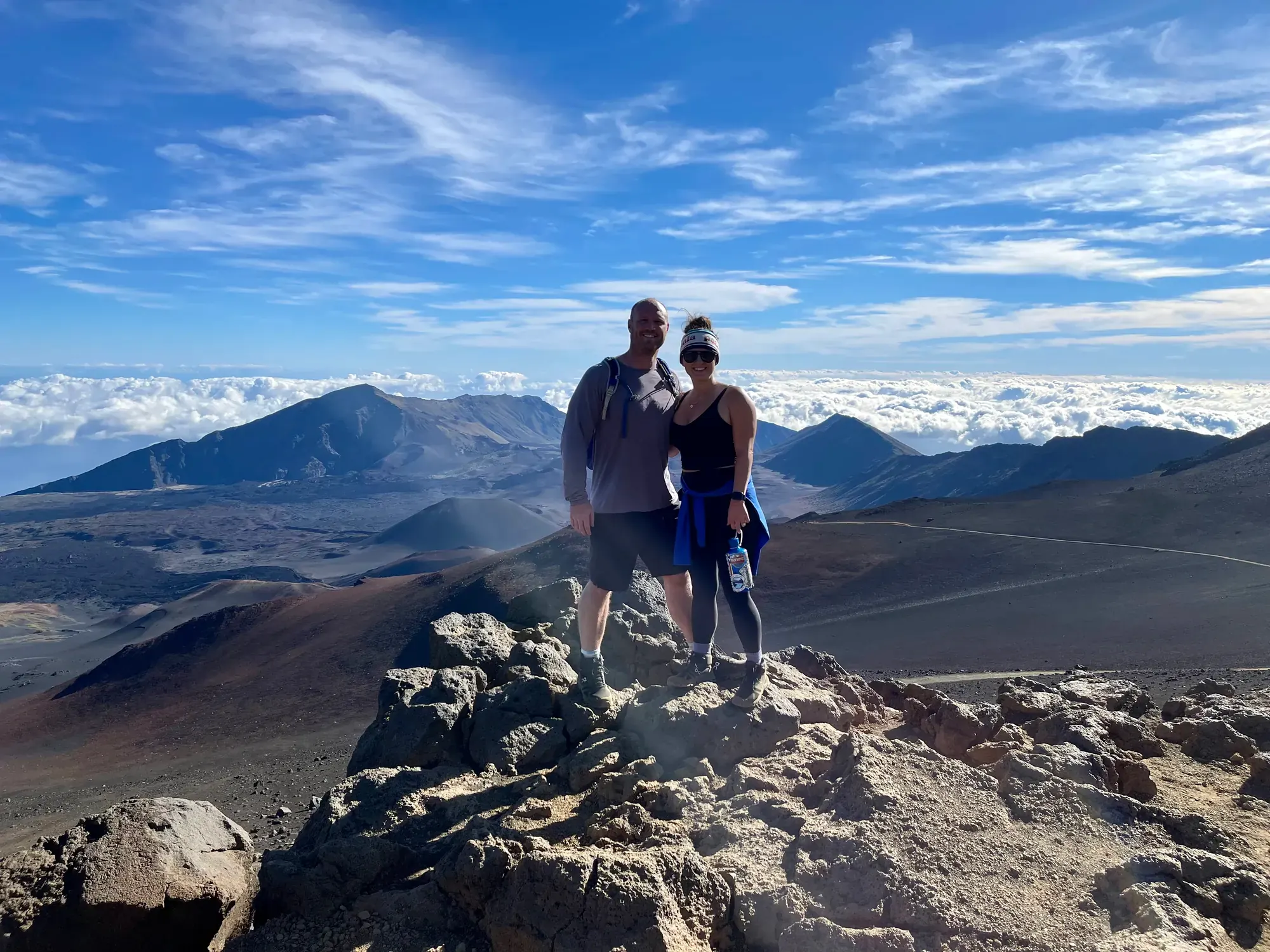
Puʻuʻulaʻula
See Maui, neighboring islands, and ocean vistas from the 10,023-foot summit. Last verified · nps.gov
Kalahaku Overlook
See the crater’s volcanic landscape. Last verified · nps.gov
Leleiwi Overlook
See the crater and Koʻolau Gap beyond native shrubland. Last verified · nps.gov
Hosmer Grove
See planted trees, native shrubland, and Hawaiian honeycreepers. Last verified · nps.gov
Waimoku Falls
See the waterfall at the end of Pīpīwai Trail; pass Makahiku Falls overlook and bamboo forest along the way. Last verified · nps.gov
Wildlife: what to look for, where and when (4)
- Nēnē (Hawaiian goose)
- Grasslands, shrublands, Kalahaku Overlook, and roadsides. · Forages throughout the day. Drive carefully and view from a distance. Last verified · nps.gov
- ʻApapane
- Hosmer Grove and near Palikū Cabin; ʻōhiʻa lehua blossoms. Stay on trails and view from a distance. Last verified · nps.gov
- ʻIʻiwi
- Flowering trees at Hosmer Grove and near Palikū Cabin. Look for the long, curved orange bill; keep your distance. Last verified · nps.gov
- Pueo (Hawaiian short-eared owl)
- Open meadows and shrublands. · Dawn and dusk; also flies by day. View from a distance and stay on trails. Last verified · nps.gov
Keep your distance: Do not feed wildlife. Stop and wait for animals to cross the road. Last verified · nps.gov
Sightings are never guaranteed.
Sunrise, sunset & night sky (3)
- Haleakalā Visitor CenterSunrise
- Crater edge, Summit District · Parking and ramp on a slight incline. Advance reservations required for Summit District entry from 3–7 a.m.; entrance fee also applies. Last verified · nps.gov
- Puʻuʻulaʻula Observation DeckSunrise
- Summit, 10,023 feet · Parking; steep ramp to viewing area. See dawn over Maui and neighboring islands. Advance reservations required for entry from 3–7 a.m. Last verified · nps.gov
- Haleakalā summitNight sky
- Summit District · Stay on paved surfaces and established trails. Dress warmly. Turn off white lights; use red lights only when necessary. Sleeping in vehicles outside campgrounds is prohibited. Last verified · nps.gov
Haleakalā was amazing. We watched sunrise and sunset above the clouds from our rooftop tent camper. We did have a reservation for Haleakalā.
Beyond hiking: kids, rangers & Junior Ranger (4)
- Junior Ranger
- Park visitor centers · Daily. All ages can complete an activity booklet to earn a badge. Last verified · nps.gov
- Ranger programsRanger program
- Locations vary by program · Offered throughout the year; check the events calendar. Rangers lead talks and special events. Last verified · nps.gov
- Cultural demonstrations
- Hale Hālāwai, Kīpahulu · When scheduled. Visit the traditional meeting house for cultural demonstrations and interpretive programs. Last verified · nps.gov
- BicyclingBiking
- Paved park roads. Entrance fee applies. No bike lane; bicycles are prohibited on trails. Last verified · nps.gov
Visitor centers & hours (3)
- Headquarters Visitor Center
- The Headquarters Visitor Center is 1 mile (1.6 km) past the Summit District entrance gate. Inside, park staff can answer questions at the information desk. A small exhibit hall features displays on the park’s natural and cultural history.
Hours: Daily 8:30 am–4:30 pm
Passport stamp here.
Last verified · NPS - Haleakalā Visitor Center
- About a 30 minute drive from the Headquarters Visitor Center, the Haleakalā Visitor Center is perched on the edge of the impressive volcanic valley. Inside, park staff can answer questions at the information desk.
Hours: Daily Sunrise–12 pm
Passport stamp here.
Last verified · NPS - Kīpahulu Visitor Center
- Located at the coastal Kīpahulu District. Information desk, exhibits on natural and cultural history, and a Hawaiʻi Pacific Parks Association bookstore inside.
Hours: Daily 9 am–5 pm
Passport stamp here.
Last verified · NPS
Hours from the National Park Service’s visitor-center data. Holiday closures and seasonal changes happen, so check the link before a long drive.
Official park & trail maps (1)
- Haleakalā park and summit hiking maps Whole park · Web page
Download before you go; many parks have little or no cell service. Maps from nps.gov, checked Nov 1, 2026.
Travel times & internal access (5)
| From → to / access mode | Distance | Time |
|---|---|---|
| Kahului → Haleakalā summitVia Routes 37, 377, and 378.Last verified · nps.gov | — | 2.5 hours |
| Wailea → Haleakalā summitPublished NPS driving estimate.Last verified · nps.gov | — | 3 hours |
| Lāhainā → Haleakalā summitPublished NPS driving estimate.Last verified · nps.gov | — | 3.5 hours |
| Kahului → Kīpahulu DistrictVia Routes 36, 360, and 31.Last verified · nps.gov | — | Approximately 4 hours |
| Summit District entrance station → Haleakalā summitClimbs another 3,000 feet.Last verified · nps.gov | 11 mi | 30 minutes |
Distances and times as the park publishes them. Road work, shuttles, wildlife jams and seasonal closures add time.
Cell, gas, food & EV charging (3 areas)
- Summit approach and park roads
Gas: No gas in the park. Pukalani is the last gas stop on the summit approach.
EV: No EV charging stations in the park.
Last verified · nps.gov- Kīpahulu approach
Gas: No gas in the park. Pāʻia is the last gas stop along Hāna Highway before Hāna.
Last verified · nps.gov- Parkwide; crater and trailheads
Cell: No service in Haleakalā Crater; very limited at trailheads.
Food: No food for sale in the park; bring your own.
Last verified · nps.gov
Coverage reports are not guarantees; carriers and chargers change.
Scenic drives, trail guides & tours
Trail guides for this park
- Summit road (Routes 377/378 into the park)
- Winding, steep road through endangered-species habitat to overlooks at Leleiwi, Kalahaku, Haleakalā Visitor Center (9,740 ft) and Puʻuʻulaʻula / Red Hill (10,023 ft). All four are sunrise viewpoints. Last verified · nps.gov
- Hāna Highway to Kīpahulu
- The famous coastal road around northeast Maui, ending 12 mi past Hāna at ʻOheʻo Gulch. Allow about 4 hours from Kahului (directions page). Bring food, and fill up with gas first. Last verified · nps.gov
Wildlife and where to see it → · All things to do →
Required gear & rules
Required (5)
| Item | Where / when | Spec / exceptions | Source |
|---|---|---|---|
| Summit sunrise reservation | Summit District · daily 3:00-7:00 am | $1 per vehicle on Recreation.gov, in addition to entrance fee. Released 60 days and two days ahead at 7 am HST. Reservation holder must present a paper reservation and photo ID; display the printout on the dashboard. · Walking or bicycling does not require a reservation. | Source |
| Sunrise reservation limit | Summit District | One sunrise reservation per three-day period; valid only for the reserved date; no weather refunds | Source |
| Animal-proof food storage | parkwide | Foodstuffs stored to prevent access by animals or insects | Source |
| Printed wilderness tent campsite reservation | Holua and Paliku wilderness sites | Reserve through Recreation.gov up to six months ahead; trip leader must carry the printed reservation at all times. Maximum three consecutive nights; three nights per 30-day period across all park sites. | Source |
| Use park toilets for human waste | parkwide | Dispose of human waste at park-established and maintained toilets. | Source |
Prohibited (5)
| Item | Where / when | Spec / exceptions | Source |
|---|---|---|---|
| Drones | NPS-administered lands and waters within Haleakalā National Park | Superintendent’s written approval | Source |
| Bringing wood into the park; wood gathering | parkwide | — | Source |
| Bringing vehicles, tools or equipment with attached soil into the park | parkwide | — | Source |
| Swimming in streams | Pipiwai and Palikea streams above Hwy 360; all waterways in Ka’apahu, Kaupo and Nu’u areas | No diving or jumping; no glass within 100 ft of streams | Source |
| Pets in backcountry, wilderness and on trails | backcountry, wilderness, trails, buildings | Service animals as defined by applicable federal law and NPS policy. | Source |
Recommended (1)
| Item | Where / when | Spec / exceptions | Source |
|---|---|---|---|
| Clean gear to help prevent rapid ʻōhiʻa death | Haleakalā crater wilderness | Clean dirt from shoes, clothing and equipment and spray with 70% alcohol | Source |
Sun, moon & dark skies
Plan a sunrise, a golden-hour photo stop, or a night under the stars.
Approximate times at the NPS park coordinate (20.707, -156.159), using Pacific/Honolulu. Terrain can hide the horizon; this is one reference point, not every location in the park.
Enable JavaScript to compute times for today or your chosen date.
- Sunrise
- —
- Sunset
- —
- Civil dawn
- —
- Civil dusk
- —
- Morning golden hour
- —
- Evening golden hour
- —
- Moon phase
- —
- Moon illumination
- —
- Moonrise
- —
- Moonset
- —
Tonight’s viewing windows
The selected date’s noon through the following noon; dates shown on both ends. Computed in 10-minute steps.
- Astronomical darkness
- —
- Milky Way core above 10° in darkness
- —
- Core window with the Moon below the horizon
- —
Computed opportunity, not a visibility forecast. Darkness means the Sun is at least 18° below the horizon. Core direction uses SIMBAD’s Sgr A* position and Earth’s sidereal rotation; season follows from the date. The Moon can wash out the core outside the moon-free window. Clouds, smoke, local lighting and terrain may prevent a view. No measured sky brightness or Bortle estimate is available here.
Dark-sky guidance
Not on the International Dark Sky Places list; that doesn’t mean the skies here aren’t dark. Sourced designation list (source updated 2025-04-16; checked 2026-11-03). Check the DarkSky International directory for changes.
Choose a permitted viewing area with an open horizon, let your eyes adapt, and keep lights low and shielded. Confirm access and current alerts before heading out. NPS night-sky guidance
From NPS: night-sky reading
Sun and Moon calculations: SunCalc 1.9.0 (BSD license). Illumination and phase are at local noon; moonrise/set cover the selected civil day. Golden hour uses sunrise to Sun +6°, and Sun +6° to sunset. Missing events are reported explicitly. Coordinates and time-zone reference: existing NPS-sourced park data, checked 2026-11-03.
Accessibility guide: trails, lodging, campsites & visitor centers
Can everyone in our group go? Kids, a dog or a wheelchair at Haleakalā →
Odds of a dry trip
Choose a start date.
No wet days1 wet day2 or more
Wet day: 0.01 in (0.3 mm) or more of precipitation, 1996–2025. Station: KULA BRANCH STN 324.5 (USC00515000), 3,125 ft, 11.1 mi from park center. Station record · NOAA GHCN-Daily
Historical frequency at this station, not a forecast. Higher trails can be wetter or snowier than the station.
Time zone
- Park time
- Your time
- Difference
- No daylight saving time: clocks here do not change in March/November, so the offset to mainland DST-observing states changes by an hour seasonally. Source
Questions we’ve answered about Haleakalā
- Should we camp or stay in a lodge?Camp if you can. Some of our best memories came from sleeping outside: Wonder Lake in Denali, a Jeep with…
Ask David & Keri about Haleakalā → · All our Haleakalā answers
Where to get the passport stamp
- Haleakalā Visitor Center · Visitor center
- Headquarters Visitor Center · Visitor center
- Kīpahulu Visitor Center · Visitor center
From the NPS list of Passport To Your National Parks stamp locations, Nov 5, 2026. Stamps can move between desks and seasons; ask a ranger if one isn’t where it’s listed. Print a checklist with every park’s stamp spots →
Emergency card
- Emergency number
- Park emergency communication center: 808-985-6170 (emergencies only) Source
- Cell coverage
- No cell service in Haleakalā Crater; very limited at trailheads. Source
- Radio / satellite
- Emergency signal devices work in the crater but should not be relied on alone. Source
- Compass
- Magnetic declination at park center, mid-2027: 9.3° E (NOAA WMM2025) Source
What to tell dispatch (NPS) Source
- GPS coordinates from your phone, if available
- Name of the trail or area of the park where you started your activity
- Your last known location before you became lost
- Description of your surroundings including visible landmarks
- Types and colors of clothing you are wearing
- Equipment you are carrying
- Any medical conditions you may have
Uses your device’s location; works without signal once this page has loaded. Nothing is sent to us.
Hikes and scenic drives in Haleakalā
-
Pā Kaʻoao
Up the puʻu beside Haleakalā Visitor Center to rock-wall shelters and a crater view.
-
Leleiwi Overlook
A short walk to a crater viewpoint, across the road from the lot. Uneven steps.
-
Hosmer Grove loop
Native shrubland and honeycreepers near the entrance.
-
Halemauʻu Trail to crater rim
Rocky path to a view of the crater and Koʻolau Gap. Rainbow Bridge is about 0.25 mi past the first viewpoint.
-
Supply Trail
Out to the Halemauʻu Trail junction.
-
Keoneheʻeheʻe (Sliding Sands) to first overlook
Starts in the Haleakalā Visitor Center lot. The 1-mile natural overlook is about 500 ft down.
-
Sliding Sands to Halemauʻu crater traverse
Allow 7-9 hours. It’s point-to-point, and there’s no park shuttle, so plan your own ride between trailheads. The NPS suggests parking at Halemauʻu.
-
Pīpīwai Trail to Waimoku Falls
In Kīpahulu: the 200-ft Makahiku Falls overlook at 0.5 mi, the bamboo forest at about 1 mi, and 400-ft Waimoku Falls at 2 mi. Muddy and rooty.
-
Kūloa Point Trail
From Kīpahulu Visitor Center to the mouth of ʻOheʻo Gulch. The best view of the pools.
-
Summit road (Routes 377/378 into the park)
Winding, steep road through endangered-species habitat to overlooks at Leleiwi, Kalahaku, Haleakalā Visitor Center (9,740 ft) and Puʻuʻulaʻula / Red Hill (10,023 ft). All four are sunrise viewpoints.
-
Hāna Highway to Kīpahulu
The famous coastal road around northeast Maui, ending 12 mi past Hāna at ʻOheʻo Gulch. Allow about 4 hours from Kahului (directions page). Bring food, and fill up with gas first.
From our Haleakalā guide; each name links its National Park Service source. Check what’s open today before you go.
Every NPS listing for Haleakalā
9 activities
Every National Park Service “things to do” listing for the park, checked Nov 6, 2026. Where the NPS blurb read like an ad, the short description is ours, with the same facts; access notes are the NPS’s own words. Each title links its official page, so confirm current conditions there.
-
Moderate Hike into Haleakalā’s Crater
Enter the park’s Wilderness on the Keoneheʻeheʻe (Sliding Sands) Trail and take a moderate out-and-back hike partway down the windswept cinder slope. This is among the most popular hikes in the park thanks to its unbeatable crater views.
Access: This trail is not accessible to wheelchairs. The first quarter-mile is rocky but flat. Beyond that point, the trail is steep and the loose cinder trail can be challenging.
-
Moderate Hike to the Crater Edge
Meander through native shrubland to glimpse rare forest birds and a variety of plants found only in Hawaiʻi.
Access: Due to the rocky, sometimes steep nature of this trail, it is unfortunately not accessible to wheelchairs. This trail enters remote sections of the parkʻs wilderness, and help may not be readily…
-
Moderate Hike up to the Bamboo Forest
Listen to the sounds of the bamboo forest as the towering stalks creak, clack, and clang along the Pīpīwai Trail! Pick up the trail to the left of the Kīpahulu Visitor Center. The hike is 1 mile (1.6 km) round trip with an average hiking…
Access: The trail is unpaved, rocky, contains exposed roots, and can be slippery following rain. There are several sets of steps along the trail and a few sections with steep grades as the trail climbs 800…
-
Short Hike to Leleiwi Overlook
A short .3 mile (.5 km) roundtrip walk past native plants to Leleiwi Overlook, which looks out over the crater and the Koʻolau Gap.
Access: This trail is unpaved and involves several steep, uneven steps.
-
Short Hike to Makahiku Falls
Golden light. Verdant forests. White waters. View Makahiku Falls from the Pīpīwai Trail in the Kīpahulu District of Haleakalā National Park.
Access: The trail is unpaved, rocky, contains exposed tree roots, and is often muddy. There are stairs along the trail in several locations and a significant amount of elevation gain in a short distance.
-
Strenuous Hike Across the Crater Floor
Experienced hikers can “thru” hike the crater from Keoneheʻeheʻe (Sliding Sands) Trailhead, across the crater floor, and out to Halemauʻu Trailhead. This hike is extremely strenuous and should only be undertaken by individuals who are…
Access: This trail is extremely long and steep. While the trailheads have accessible parking, this trail is not recommended for who may require assistance.
-
Become a Haleakalā Junior Ranger
Complete activities featuring the plants, animals, and history of Haleakalā to earn your Junior Ranger badge!
Access: Digital activites online are accessible for visitors using screen readers.
-
Enjoy the Sunrise
Start your day at the top of Haleakalā. With an advance sunrise reservation, visitors can await the dawn from any of four lookouts leading to the summit.
Access: The most easily accessed spot to view sunrise is from the Haleakalā Visitor Center. Accessibility here includes accessible park spots, a ramp up a slight incline, and accessible restrooms.…
-
Shopping
The HPPA operates three bookstores at Haleakalā National Park and they are located at Park Headquarters, Haleakalā Visitor Center, and Kīpahulu Visitor Center. The HPPA also maintains an online bookstore.
Access: Stores mentioned may have stairs and narrow entrance ways.
Nothing matches. Clear a filter.
Traveling with kids, a dog or a wheelchair? See Haleakalā with kids, a dog or a wheelchair.
Sources: National Park Service and the links alongside each detail. Back to the Haleakalā guide.
Book a guided tour in Haleakalā
Affiliate link: we may earn a commission, at no extra cost to you. How this works
Affiliate link: we may earn a commission, at no extra cost to you. How this works