
CanyonlandsItinerary
Canyonlands itinerary
Free one- and two-day Canyonlands plans for Island in the Sky and The Needles, with an optional third day to hike to Chesler Park Viewpoint.
By David & Keri New, who have visited 63 of the 64 U.S. national parks
Canyonlands · Photo: David & Keri New
Choose your days
Spend one day at Island in the Sky and give The Needles its own day. The districts have separate entrances and no road connects them inside the park. Add a third day if you want a longer hike.
Check the paved approaches and any unpaved trailhead road separately. Rain and snow can change conditions quickly. Check NPS road conditions
David and Keri’s favorite: Mesa Arch.
Times are suggested local starts. Closure flags update from the NPS alert feed when available. Check conditions again before your visit. Check park alerts
Taking an RV or trailer over 25 feet in total length? NPS lists designated parking stops. At The Needles, stay on the paved scenic drive with that rig. NPS parking information
Open the free one-page planner
1 day
Make time for Mesa Arch
Add your dates and save a copy.
Day 1 · Island in the Sky · mesa and canyon overlooks
About 40 minutes from Moab to the Island in the Sky Visitor Center via US 191 and UT 313. Allow extra time to reach the Mesa Arch trailhead. Drive time source
Check the paved Scenic Drive before leaving. In snow or ice, keep to open overlooks and skip exposed slickrock if footing is poor. Access source
3 stops in order. Positions from OpenStreetMap; map data loads from OpenStreetMap when you tap. Not for navigation.
-
Mesa Arch
Take the short trail to the arch. For sunrise, plan to arrive before first light.
Our tip For sunrise at Mesa Arch, show up well before first light, because photographers line up early. For sunset, Green River Overlook faces southwest, so arrive before the light changes and bring a layer for after dark. David & Keri
Facts for Mesa Arch
Short hike to a natural stone arch perched at the mesa’s edge, framing views of La Sal Mountains and the canyon below. 1
- Distance
- 0.6 miles round trip 1
- Elevation
- 56 feet elevation change; not labelled cumulative gain. 1
- Time
- 30 minutes 1
- Difficulty
- Easy; rocky hill and stone steps 1
- Where
- Island in the Sky 1
- Walking
- 0.6 mi loop 1
- Accessibility
- Accessibility : This trail can be rough, uneven, and requires walking up and down a rocky hill and stone steps. It is not accessible to wheelchairs. In winter, there may be snow or icy conditions; we recommend traction devices for hikers. 1
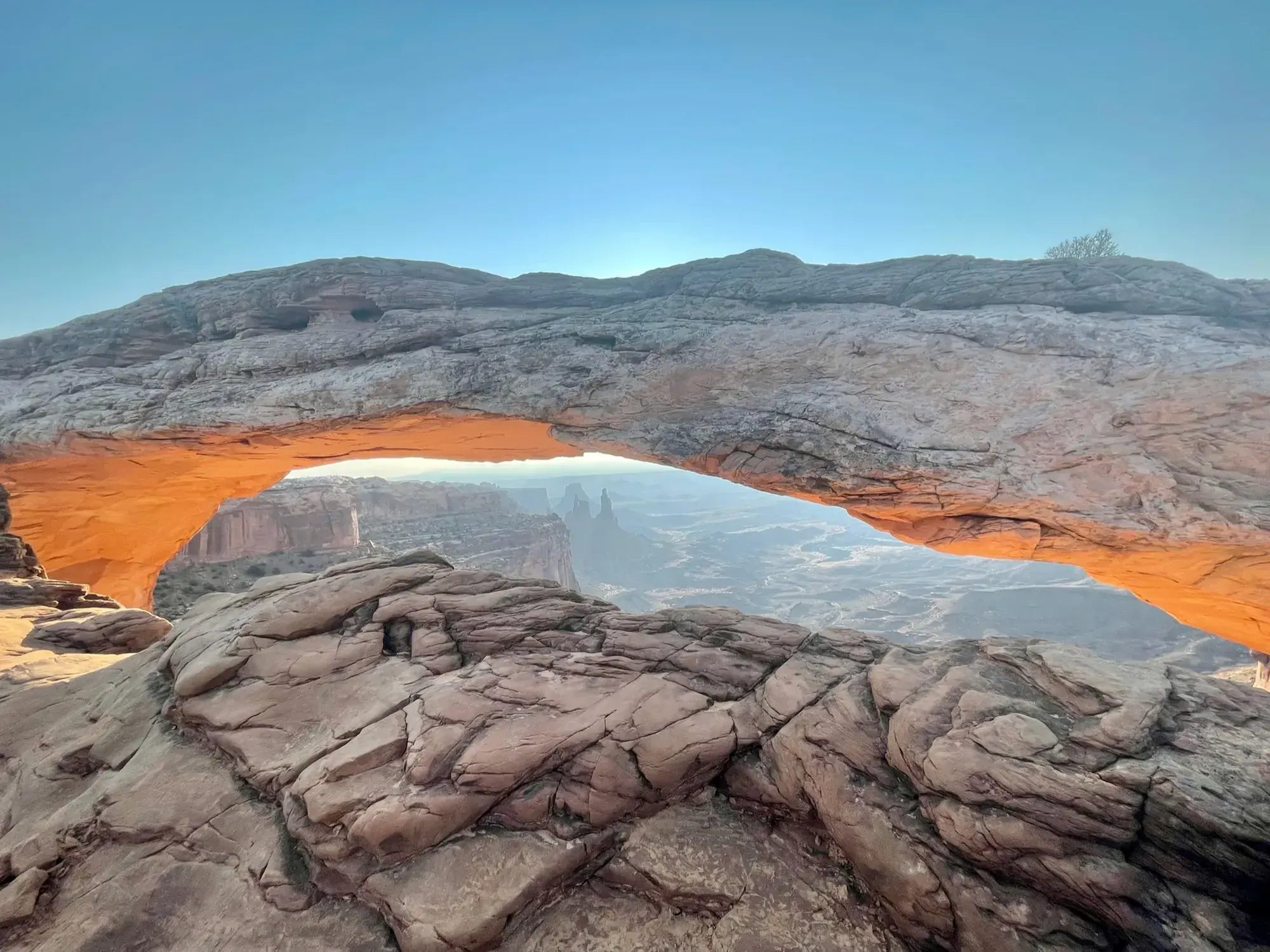
The underside of Mesa Arch went orange as the sun came up. · Sep 2021 · Our photo -
Grand View Point
Walk out to the paved viewpoint. If conditions are good, take the 1.8-mile round-trip trail along the rim.
Facts for Grand View Point
See canyons, the White Rim Road, distant mountains, and other park districts. 1
-
Green River Overlook
Take a picnic break and look out over the Green River canyon. If you have another short hike in you, finish at the first Upheaval Dome overlook.
Facts for Green River Overlook
See the Green River 1,300 feet below, the White Rim Road, and features of The Maze. 1
Stay near Moab for the next morning’s drive south to The Needles. Source
2 days
Make time for Slickrock Trail
Add your dates and save a copy.
Day 1 · Island in the Sky · mesa and canyon overlooks
About 40 minutes from Moab to the Island in the Sky Visitor Center via US 191 and UT 313. Allow extra time to reach the Mesa Arch trailhead. Drive time source
Check the paved Scenic Drive before leaving. In snow or ice, keep to open overlooks and skip exposed slickrock if footing is poor. Access source
3 stops in order. Positions from OpenStreetMap; map data loads from OpenStreetMap when you tap. Not for navigation.
-
Mesa Arch
Take the short trail to the arch. For sunrise, plan to arrive before first light.
Our tip For sunrise at Mesa Arch, show up well before first light, because photographers line up early. For sunset, Green River Overlook faces southwest, so arrive before the light changes and bring a layer for after dark. David & Keri
Facts for Mesa Arch
Short hike to a natural stone arch perched at the mesa’s edge, framing views of La Sal Mountains and the canyon below. 1
- Distance
- 0.6 miles round trip 1
- Elevation
- 56 feet elevation change; not labelled cumulative gain. 1
- Time
- 30 minutes 1
- Difficulty
- Easy; rocky hill and stone steps 1
- Where
- Island in the Sky 1
- Walking
- 0.6 mi loop 1
- Accessibility
- Accessibility : This trail can be rough, uneven, and requires walking up and down a rocky hill and stone steps. It is not accessible to wheelchairs. In winter, there may be snow or icy conditions; we recommend traction devices for hikers. 1
-
Grand View Point
Walk out to the paved viewpoint. If conditions are good, take the 1.8-mile round-trip trail along the rim.
Facts for Grand View Point
See canyons, the White Rim Road, distant mountains, and other park districts. 1
-
Green River Overlook
Take a picnic break and look out over the Green River canyon. If you have another short hike in you, finish at the first Upheaval Dome overlook.
Facts for Green River Overlook
See the Green River 1,300 feet below, the White Rim Road, and features of The Maze. 1
Stay near Moab for the next morning’s drive south to The Needles. Source
Day 2 · The Needles · scenic drive and shorter walks
About 1 hour 30 minutes from Moab to The Needles Visitor Center via US 191 and UT 211. If leaving directly from Island in the Sky, budget about 2 hours 15 minutes via Moab between visitor centers. Allow extra time for stops and park roads. Drive time source
UT 211 is the paved approach. Check for flooding and stick to open roads. If you only have two days and Chesler Park is your priority, use the optional hiking day in place of this shorter day. Access source
3 stops in order. Positions from OpenStreetMap; map data loads from OpenStreetMap when you tap. Not for navigation.
-
Pothole Point
Follow cairns across uneven slickrock on the short loop. For a briefer walk, stop at Stone Storehouse instead.
Facts for Pothole Point
- Accessibility
- Accessibility : This trail can be rough, uneven, and requires walking up and down a rocky hill and stone steps. It is not accessible to wheelchairs. In winter, there may be snow or icy conditions; we recommend traction devices for hikers. 1
-
Slickrock Trail
Give this 2.4-mile hike about two hours for broad views of the district. Skip it if heat or slick rock makes conditions poor.
Facts for Slickrock Trail
- Accessibility
- Accessibility : This trail can be rough and uneven. It is not accessible to wheelchairs. In winter, there may be snow or icy conditions; we recommend traction devices for hikers. 1
-
Big Spring Canyon Overlook
Finish at the overlook at the end of the paved scenic drive. Leave time for the drive back out to US 191.
Facts for Big Spring Canyon Overlook
See rock spires and colorful sandstone benches around a canyon bend. 1
Stay near The Needles Campground if you can get a site, or Monticello if you want to avoid driving back to Moab before the optional hike. Source
Optional day 3 · The Needles
Make time for Chesler Park Viewpoint
Add this after the 2-day plan.
Add your dates and save a copy.
Day 3 · The Needles · Chesler Park Viewpoint hike
If you stayed in Moab, budget about 1 hour 30 minutes to The Needles Visitor Center plus time for the unpaved Elephant Hill Access Road. Drive time source
Check Elephant Hill Access Road before setting out. If you cannot reach the trailhead, ask a ranger whether the longer approach from Needles Campground Loop A is open and suitable. If access or weather is poor, skip this hike. Access source
-
Chesler Park Viewpoint
From the Elephant Hill trailhead, the viewpoint is a strenuous 5.8-mile round trip. Allow three to four hours in good conditions. Take water and an offline map, and turn back at the viewpoint.
Facts for Chesler Park Viewpoint
This popular trail leads to a pass overlooking a scenic expanse of desert grasses and shrubs surrounded by sandstone spires. 1
- Distance
- 5.8 miles round trip 1
- Elevation
- 533 feet overall elevation change; NPS explicitly says cumulative gain is much greater. 1
- Time
- 3–4 hours 1
- Difficulty
- Strenuous 1
- Accessibility
- Accessibility : This trail can be rough, uneven, and requires walking and scrambling on rocky slopes. It is not accessible to wheelchairs. In winter, there may be snow or icy conditions; we recommend traction devices for hikers. 1
Good to know
For your days in Canyonlands
Wildlife and where to look (4)
- Desert bighorn sheep. Talus slopes and side canyons along the rivers; year-round. nps.gov
- Beaver. Banks of the Colorado and Green rivers. Look for bank dens rather than dams in these broad, swift rivers. nps.gov
- Canyon wren. Canyon walls and river corridors; spring and summer mornings along rivers. Listen for calls echoing from canyon walls. nps.gov
- Great blue heron. Shallows along river corridors. Look for birds hunting fish in shallow water. nps.gov
Night sky and light (3)
- Mesa Arch (Island in the Sky). 0.6 mi loop over rocky terrain and steps. Popular with photographers at sunrise; winter ice is possible. nps.gov
- Green River Overlook (Island in the Sky). NPS names this southwest-facing viewpoint as a sunset location. nps.gov
- Canyonlands International Dark Sky Park (Park-wide). Designated a Gold-Tier International Dark Sky Park in 2015. nps.gov
Longer drives between areas (4)
- Moab to Island in the Sky Visitor Center: about 40 minutes. Via US 191 and UT 313. nps.gov
- The Needles Visitor Center to Big Spring Canyon Overlook: 6.5 miles, . At the end of the paved park road. nps.gov
- Green River to Horseshoe Canyon west rim: 47 miles, about 1.5 hours. Dirt access road; weather can make four-wheel drive necessary. nps.gov
- Moab to Horseshoe Canyon west rim: about 2.5 hours. Check road conditions; use a map instead of relying on GPS. nps.gov
Signal, wifi and charging (3)
- Island in the Sky: Limited at visitor center and scenic-drive locations with La Sal Mountain views; coverage varies. Public unsecured Wi-Fi at visitor center. nps.gov
- The Needles: Little to no service, including visitor center and campground. Public unsecured Wi-Fi at visitor center. nps.gov
- The Maze: Limited near Hans Flat with La Sal Mountain views; little to none in backcountry. No Wi-Fi service. nps.gov
As the NPS lists it; coverage changes, so don’t count on a signal on the trail.
Add a guided tour to your Canyonlands days
Affiliate link: we may earn a commission, at no extra cost to you. How this works
Affiliate link: we may earn a commission, at no extra cost to you. How this works
Before you go
- Canyonlands permits and reservations: lotteries, campground and lodging booking windows.
- Best time to visit Canyonlands: crowds, weather and seasonal access by month.
- Plan Canyonlands in the trip planner: your dates, booking deadlines and a conditions check before you leave.
- Is Canyonlands open today? Live NPS alerts and closures.
Plans checked against official NPS pages Nov 10, 2026.