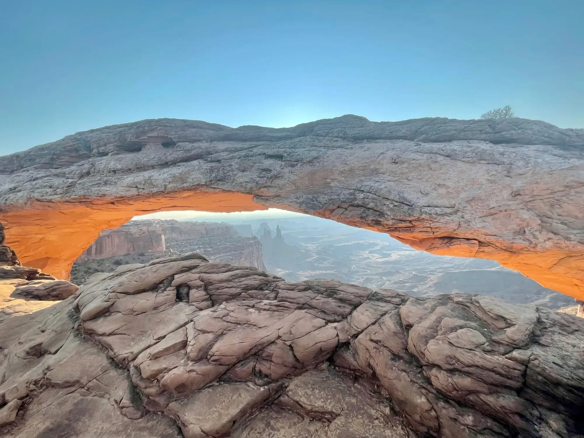
Mesa Arch Trail
Short hike to a natural stone arch perched at the mesa’s edge, framing views of La Sal Mountains and the canyon below.
Canyonlands · Photo: David & Keri New
- 0.6 miDistance
- 30 minTime
- EasyDifficulty
The numbers, with sources
Distance: 0.6 miles round trip Source
Gain: The NPS doesn’t publish the elevation gain. Source
Time: 30 minutes Source
Difficulty: Easy; rocky hill and stone steps Source
Trailhead: Use the signed trailhead named on the NPS trail page. Source
Route type: loop Source
Built from official sources (checked Nov 3, 2026). Confirm current conditions with the park.
Recreation.gov permits, entrances & campgrounds
Recreation.gov (RIDB). Booking records date not published. NPS guidance above takes precedence. A listing doesn’t mean you need a permit or that there’s space on your dates.
Park campground options (2)
These records belong to the park’s NPS recreation area. We haven’t checked how close these are to the trail, when they open or whether sites are free; check the map and the booking page.
Canyonlands National Park Needles District GROUP Campsites — Campground; RIDB reservable: yes. Season: not published in structured RIDB data. Recreation.gov (RIDB) source · Booking details
NPS reservation guidance: You may book group campsites up to six months in advance throughout the season: March 15 – November 15. NPS source
Canyonlands National Park Needles District Campground — Campground; RIDB reservable: yes. Season: not published in structured RIDB data. Recreation.gov (RIDB) source · Booking details
NPS reservation guidance: You may book individual campsites in Loop B up to six months in advance for nights between March 15 and November 15. Make reservations online here or by calling Recreation.gov at 1-877-444-6777. Loop A is available first come, first served only. Group sites are open March 15 through November 15. You may reserve these sites up to six months in advance. Group sites are closed in winter. NPS source
Route, junction by junction
Trailhead → Selected destination or loop
The NPS says going counterclockwise puts a bit more of the elevation change at the start. To reduce the number of stairs, the park suggests approaching clockwise and retracing the same way. That option changes the route shape from the full loop; do not assume its distance is identical to the published loop mileage. Source
No elevation profile: we only draw one from a mapped route we can verify. Route source
In-depth guide
Compiled from linked sources, checked Nov 2, 2026. Each paragraph links to its source.
Is this hike for you?
Mesa Arch is a short loop in Island in the Sky to a 27-foot-long (8.3 m) arch at the edge of the mesa, framing the canyon far below and the La Sal Mountains in the distance. The NPS rates it easy: 0.6 mi (1 km) round trip, about 30 min, with 56 ft (17 m) of elevation change. Short as it is, it’s rough and uneven, with a rocky hill and stone steps, and the arch sits on a cliff edge. Source
The trail
Going counter-clockwise, the loop has a bit more elevation change at the start. To take fewer stairs, walk clockwise to the arch and come back the same way (that’s not quite the full loop, so the distance may differ). Stay on the trail near the edge. Source
Mesa Arch is one of the most photographed arches in southeast Utah, and it’s a classic sunrise spot: groups of photographers often wait for the glow on the underside of the arch. Expect company at sunrise. The view toward the La Sal Mountains is good any time of day. Source
Getting to the trailhead
The NPS page doesn’t give driving directions. Use the park map and look for the signed trailhead; a map pin on the arch itself isn’t the parking area. Source
Dogs, permits and fees
Dogs aren’t allowed on this trail. Service animals are allowed in national parks. We found no permit or reservation requirement for the hike. Source
Check the NPS fees page for the park entrance fee. Source
Water and food
The NPS doesn’t list water or restrooms at the trail. Bring water and use the restroom before you start. Source
Kids, strollers and wheelchairs
The NPS says the trail isn’t accessible to wheelchairs; it has a rocky hill and stone steps. It doesn’t give a minimum age; with kids, the cliff edge at the arch is the thing to watch. Source
Before you go
In winter there may be snow or ice, and the NPS recommends traction devices. The NPS doesn’t give a season for the trail. Check the park’s current alerts and the forecast before you go, and look at the signs at the trailhead. Source · Source 2
Elevation profile
There’s no elevation profile yet: the NPS trail map line comes from its trail data and USGS 3DEP terrain, but we haven’t verified complete measurements for this route. Source
Getting there and back
Check the official map for where the trail starts. Source
Return: Come back the way described above. Complete the chosen loop to the original start. Source
Water
No complete route-specific drinking-water or restroom schedule confirmed. Carry water for the whole hike. Source
Hazards
Read the NPS trail page and current conditions before you go. Source
Season
Use current official conditions; activity season labels are not a guarantee of access. Source
Current trail conditions require a trip-date check. Source
Gear & rules
Follow current signs and closures, and treat any side trip as a separate decision. Source
Filling a gap in your kit? Compare these packing essentials on Amazon. Choose gear for your route, conditions and the park’s guidance.
As an Amazon Associate we earn from qualifying purchases. How this works
The NPS doesn’t publish a pet rule for this exact route. Confirm the applicable rule before bringing an animal. Source
Questions
Which route do these figures describe?
0.6 miles round trip Mesa Arch is an Island in the Sky loop to a cliff-edge arch. NPS gives 0.6 miles round trip and about 30 minutes, but the short distance includes a rocky hill and stone steps. The viewpoint is at a mesa edge, so the destination deserves more care than its easy difficulty label alone suggests. Source
Is the trail open right now?
No. NPS details as of Nov 3, 2026. Confirm current conditions and closures with NPS. Source
Is there a measured elevation profile?
Official NPS trail geometry sampled with USGS 3DEP terrain; no mileage or gain scaling. NPS publishes 0.60 mi for the loop; the traced line measures 0.69 mi. The difference is unresolved. Source
Alternatives
Sunrise is especially popular with photographers, per the NPS. That is crowd context, not a reservation system or a promised arrival time for an empty view. The arch also frames canyon and mountain views at other times of day. Winter snow and ice can affect the rocky approach, and NPS recommends traction devices in those conditions. Source
Camp near Mesa Arch Trail
Closest campgrounds by drive time to Mesa Arch Trailhead:
- 1 hr 6 min Courthouse Rock Campground ↗ (32.6 mi, Bureau of Land Management)
- 1 hr 24 min Ken’s Lake Campground ↗ (49.4 mi, Bureau of Land Management)
- 2 hr Windwhistle Campground ↗ (77.2 mi, Bureau of Land Management)
- 2 hr 34 min Superbowl Campground ↗ (104 mi, Bureau of Land Management)
- 2 hr 46 min Creek Pasture Campground ↗ (105.8 mi, Bureau of Land Management)
Driving time with no traffic (OSRM, OpenStreetMap roads). Some park roads are shuttle-only in season. All camping near Canyonlands
More Canyonlands trail guides
- Chesler Park Viewpoint Trail5.8 mi · Strenuous