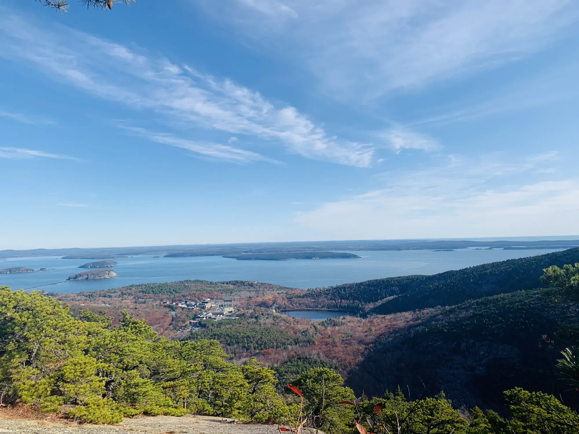
Precipice Loop
The Precipice Trail climbs the exposed east face of Champlain Mountain using iron rungs and ladders. NPS advises returning by Champlain North Ridge Trail because descending the Precipice Trail is dangerous.
Acadia · Photo: David & Keri New
- 3.2 miDistance
- 1,000 ftElevation gain
- 2–3 hrTime
- StrenuousDifficulty
The numbers, with sources
Distance: 3.2 miles round trip Source
Gain: Over 1,000 feet in the 0.9-mile Precipice ascent; total loop gain is not published. Source
Time: 2–3 hours Source
Difficulty: Strenuous; rugged, non-technical climb Source
Trailhead: Precipice Trailhead, Park Loop Road Source
Route type: loop Source
Built from official sources (checked Nov 3, 2026). Confirm current conditions with the park.
Recreation.gov permits, entrances & campgrounds
Recreation.gov (RIDB). Booking records date not published. NPS guidance above takes precedence. A listing doesn’t mean you need a permit or that there’s space on your dates.
Nearby campground records
Within 10 straight-line miles of the trailhead. Distances are straight-line from map coordinates, not driving distances.
- BLACKWOODS CAMPGROUND: approximately 2.9 miles straight line. RIDB coordinates · Mapped route source
- SEAWALL CAMPGROUND: approximately 9.5 miles straight line. RIDB coordinates · Mapped route source
- Schoodic Woods Campground: approximately 6.3 miles straight line. RIDB coordinates · Mapped route source
Park campground options (4)
These records belong to the park’s NPS recreation area. We haven’t checked how close these are to the trail, when they open or whether sites are free; check the map and the booking page.
BLACKWOODS CAMPGROUND — Campground; RIDB reservable: yes. Season: not published in structured RIDB data. Recreation.gov (RIDB) source · Booking details
NPS reservation guidance: Ninety percent of campsites are released six months in advance on the first of each month at 10 am EST. The remaining 10 percent are released at 10 am 14 days ahead of a desired arrival date on a rolling basis. All campsite reservations must be made in advance at Recreation.gov. Reservations cannot be made through the campground office or in-person. NPS source
SEAWALL CAMPGROUND — Campground; RIDB reservable: yes. Season: not published in structured RIDB data. Recreation.gov (RIDB) source · Booking details
NPS reservation guidance: Ninety percent of campsites are released six months in advance on the first of each month at 10 am EST. The remaining 10 percent are released at 10 am 14 days ahead of a desired arrival date on a rolling basis. All campsite reservations must be made in advance at Recreation.gov. Reservations cannot be made through the campground office or in-person. NPS source
DUCK HARBOR CAMPGROUND — Campground; RIDB reservable: yes. Season: not published in structured RIDB data. Recreation.gov (RIDB) source · Booking details
NPS reservation guidance: Reservations are required to camp at Duck Harbor Campground. Reservations are available 7 months in advance of the reservation date. All reservations are released at 10 am April 1 for the entire season. NPS source
Schoodic Woods Campground — Campground; RIDB reservable: yes. Season: not published in structured RIDB data. Recreation.gov (RIDB) source · Booking details
NPS reservation guidance: Ninety percent of campsites are released six months in advance on the first of each month at 10 am EST. The remaining 10 percent are released at 10 am 14 days ahead of a desired arrival date on a rolling basis. All campsite reservations must be made in advance at Recreation.gov. Reservations cannot be made through the campground office or in-person. NPS source
Route, junction by junction
Precipice Trailhead → Orange and Black Path junction
The loop begins by traversing a rugged slope. A wooden bridge and occasional iron handrails help climbers cross narrow, exposed ledges. At the Orange and Black Path junction, stay left on Precipice Trail. This approach already involves the exposure and irregular footing that characterize the route. Source
Junction: Orange and Black Path / Precipice Trail: Keep left on Precipice Trail at the ascent junction. Source
Orange and Black Path junction → Champlain Mountain summit
Climb several series of long iron rungs and ladders on the open vertical cliff face. Continue over granite slopes to the summit of Champlain Mountain. NPS describes summit views over Frenchman Bay and the surrounding area. The full Precipice ascent rises more than 1,000 feet in 0.9 mile; that is an ascent-wide measurement, not a distance or gain assigned solely to this section. Source
Champlain Mountain summit → Champlain North Ridge / Orange and Black Path junction
Return on Champlain Mountain’s North Ridge Trail rather than descending the iron-rung Precipice route. The descent is moderately steep and crosses open granite. At the next junction, 0.6 mile from the summit, turn right onto Orange and Black Path. Continuing left instead stays on North Ridge toward a small alternate parking area and requires a Park Loop Road walk back. Source
Distance: 0.6 mile to the next junction Source
Junction: Champlain North Ridge / Orange and Black Path: Turn right onto Orange and Black Path for the described loop; left continues North Ridge toward alternate parking on Park Loop Road. Source
Orange and Black Path junction → Split at base of stone staircase
Follow Orange and Black Path, where NPS warns of several steep sections. At the base of a stone staircase the path splits. The right branch traverses the steep east face of Champlain and intersects Precipice Trail. For the easier return described by NPS, turn left toward Park Loop Road. Source
Junction: Orange and Black Path split: Turn left for the easier return down to Park Loop Road. The right branch traverses the steep east face and intersects Precipice Trail. Source
Orange and Black Path split → Park Loop Road and Precipice parking area
Descend to Park Loop Road on the left branch of Orange and Black Path. At the road, turn right and walk back to the original parking area. This final section is a road walk: NPS specifically warns visitors to watch for traffic. No distance for the road section is published on the trail page. Source
Junction: Park Loop Road: Turn right and walk back to the Precipice parking area; watch for traffic. Source
No elevation profile: we only draw one from a mapped route we can verify. Route source
In-depth guide
Compiled from linked sources, checked Nov 3, 2026. Each paragraph links to its source.
Decisions & preparation
We only show a leg’s distance when the NPS publishes it. We don’t split the total into made-up pieces. Source
Turnaround & return planning
Decide before you start; once you’re on the rungs, keep going and take the North Ridge descent rather than climbing back down. Turn back early only before the climbing starts. Don’t count on a pickup or a shortcut. Planning basis
Parking & transport timing
The Precipice lot is on the one-way part of Park Loop Road, about 1.5 miles past Sieur de Monts Spring. No public transportation serves this trailhead, and the NPS doesn’t say when the lot fills. Source
The NPS trail page says there’s no public transportation to Precipice Trailhead. Don’t count on the Island Explorer, which serves other Acadia trailheads, to stop here. Drive to the Precipice lot on the one-way part of Park Loop Road. Shuttle source
What to bring by season
All seasons: the NPS Ten Essentials (navigation, sun protection, extra clothing, a light, first aid, fire supplies where allowed, repair tools, extra food, water and emergency shelter). Leave your plan and return time with someone. Source
Hot weather: sun protection, plenty of water and extra food. Cold or wet weather: warm layers and rain gear, plus extra clothing in case you’re out longer than planned. Source
Precipice and nearby trails close seasonally while peregrine falcons nest. The trail page mentions courtship and pre-nesting in spring and early summer and says to check current conditions before hiking. A season label doesn’t let you into a posted closure. Source
An NPS announcement from March 2026 says the trails close to protect peregrines and that entering a closed area violates federal regulations. It doesn’t give a reopening date. Source
Children & mobility
The Precipice Loop isn’t accessible. It has uneven footing, climbing, iron rungs and ladders, and steep, exposed granite throughout. There are no accessible restrooms at the trailhead. Source
Is this hike for you?
Precipice is a rugged, non-technical climb up open cliff faces on iron rungs and ladders. It takes mental and physical strength, and the NPS lists it for ages twelve and older and doesn’t recommend it for small children. Talk through everyone’s comfort with heights, strength and reach before you go, and let anyone opt out without pressure. Source
Don’t plan on turning around halfway up. The park asks you not to climb down Precipice, so once you’re on the rungs, the way off is over the top and down the loop. If anyone is uneasy at the start, pick a different hike. Source
The trail
The loop is 3.2 miles round trip, and the climb itself rises more than 1,000 feet in 0.9 mile to the summit of Champlain Mountain. You come down the North Ridge Trail, which is moderately steep on open granite, then Orange and Black Path, which has several steep sections. The last stretch is a walk along Park Loop Road back to the lot, so watch for traffic. The step-by-step route is in the plan below. Source
Bring a topographic map, as the park recommends; the park handout map is too broad for hiking. Follow the signs and blue blazes, and stop at junctions after the summit so everyone knows which way is next. Leave cairns as you find them and don’t build new ones, since changed markers can mislead other hikers. Source · Source 2
Falcon closures
Precipice and nearby trails close seasonally while peregrine falcons nest, and walking into a closed area breaks federal rules. Check the park’s current trail status before you go. Source
Peregrines nest on steep cliffs, laying eggs in a scrape on a sand- or gravel-covered ledge. People nearby can distract the adults from their eggs or chicks and even make them abandon the nest, which leaves chicks exposed to cold, starvation and predators. Adults may dive at intruders. Stay out of closed areas, and don’t look down on a nest from above. Source · Source 2
Getting to the trailhead
Park Loop Road runs 27 miles around the east side of Mount Desert Island, with a one-way section toward Sand Beach. The Precipice lot is on that one-way section, so check the direction of travel, and if you miss the turn, keep going with traffic. There’s no public transportation to this trailhead. The NPS doesn’t say when the lot fills. Source · Source 2
In winter, the part of Park Loop Road usually open to cars runs from the entrance station to Otter Cliff Road. Other sections may be open for nonmotorized use only. Check alerts before a winter trip. Source
In 2026, vehicle reservations applied only to Cadillac Summit Road, from May 20 through October 25. Other areas didn’t need one. A Cadillac reservation doesn’t cover the park entrance pass, which is separate, and neither one overrides a trail closure. Source
Before you go
Bring enough water for the whole loop. Carry a flashlight and a paper map, not just your phone: limited cell service, GPS and flashlight use drain a phone fast. Pack layers for changing weather. Source · Source 2
Ticks are most active from late spring to early fall, so wear long pants, use repellent and check for ticks afterward. Poison ivy grows throughout Acadia. Source
If Precipice isn’t for you
Ocean Path is accessible from the upper Sand Beach parking area to Thunder Hole. Thunder Hole’s parking area is the most accessible entrance, with a ramp and crosswalk. Past Thunder Hole toward Otter Point the path gets uneven and has granite staircases. Check current conditions before you go. Source
The NPS also has a page on birding at the Precipice. Check it for where you can watch the falcons without entering a closure. Source
Park rules
Acadia doesn’t allow backcountry camping, bicycles or horses on hiking trails, or swimming or wading in public water supplies. Source
Sources & planning limits
Reviewed 2026-11-03. Check current conditions for your trip dates.
Getting there and back
The Precipice lot is on the one-way Park Loop Road, approximately 1.5 miles past Sieur de Monts Spring. No public transportation serves this trailhead. Source
Shuttle: The NPS trail page explicitly says there is no public transportation to Precipice Trailhead. Do not assume that the Island Explorer service to other Acadia trailheads provides a stop here. The published access directions use the Precipice parking lot on the one-way section of Park Loop Road. Source
Return: Descending Precipice Trail is dangerous and not advised. Return from the summit on Champlain North Ridge Trail; in 0.6 mile turn right onto Orange and Black Path. At the lower split, NPS describes the left branch down to Park Loop Road as the easier return. Turn right on the road and walk back to the parking area, watching for traffic. Source
Water
There are no accessible restrooms at the trailhead. The page does not state whether other toilets or drinking water are available. Source
Acadia’s general hiking guidance says to carry at least 1 liter of water and more on warmer days. The Precipice safety tips also say to bring water and snacks. Neither opened hiking page identifies a dependable on-route tap or drinking-water supply for this loop. Source
Hazards
Open cliffs and iron rungs
This is a rugged, non-technical climb that requires both physical and mental strength. The route includes boulders, granite stairs and slopes, iron rungs, sheer cliffs and rocky trails. NPS does not recommend it for small children or people afraid of heights. Source
Wet weather
NPS does not recommend the route for anyone in wet weather. Its exposed ledges, steep granite and ladder sections are integral parts of the climb rather than optional side trips. Source
Descending the ascent
Descending Precipice Trail is dangerous and not advised. The official loop instead descends the North Ridge, where open granite and additional steep sections still require care. Source
Road traffic on return
The easier return uses Park Loop Road for the final walk to the parking area. NPS specifically says to watch for traffic. Source
Ticks
NPS advises staying in the center of the trail, avoiding brush and doing a tick check after visiting. This accompanies the route’s safety advice, rather than a claim about a particular seasonal tick population. Source
Season
The trail and associated trails close seasonally to protect nesting peregrine falcons. Check current conditions before visiting; this page does not publish fixed annual reopening dates. Source
Precipice and associated trails close seasonally to protect peregrine falcons during nesting. The trail page describes courtship and pre-nesting activity in spring and early summer and tells visitors to check current conditions before hiking. A general season label is not permission to enter a posted closure. Source
The opened March 2026 NPS announcement identifies peregrine protection as the reason for trail closures and warns that entry into a closed area violates federal regulations. It announces the closure. It doesn’t give a reopening date. Source
Gear & rules
No pets because of rungs, ladders and steep sections. Source
Public entry into a closed area violates federal regulations. Source
Filling a gap in your kit? Compare these packing essentials on Amazon. Choose gear for your route, conditions and the park’s guidance.
As an Amazon Associate we earn from qualifying purchases. How this works
Bring a map, water, snacks, compass and extra layers for unpredictable weather changes. NPS recommends closed-toe shoes with good traction. The trail has steep sections, iron rungs, handrails and exposed ledges. Source
Pets are not allowed because of the iron rungs, ladders and many steep sections. This route-specific rule applies even though some other Acadia trails allow leashed pets. Source
Follow blue trail blazes and use a topographic map. Acadia’s general hiking rules say not to modify or build new cairns, not to feed or disturb wildlife, and not to bring bicycles or horses onto hiking trails. Source
The activity has no reservation requirement, but a park entrance pass is required year round. Seasonal wildlife closures still prohibit entry into the affected area. Source
Pace
NPS gives 2–3 hours at an average pace for the 3.2-mile loop. It explains that actual duration depends on pace, frequency of stops and terrain; no time is assigned to an individual ladder section, summit stretch or return segment. Source
Questions
Is this a technical rock climb?
NPS describes it as a rugged, non-technical climb, but it includes open cliff faces, iron rungs and ladders and requires physical and mental strength. The activity lists ages 12 and older and does not recommend the trail for small children. Source
Can the ascent be used for the return?
NPS advises against descending Precipice Trail. Its return follows Champlain North Ridge Trail, Orange and Black Path and the road walk back to the lot. Source
Is the loop accessible?
No. NPS says the loop is not accessible because of uneven footing, climbing, iron rungs and ladders, and steep exposed granite. It also says there are no accessible restrooms at the trailhead; this doesn’t confirm whether other toilets exist. Source
How is the trailhead reached by car?
From ME Route 3, enter at Hulls Cove and follow Park Loop Road 2.8 miles before turning left onto the one-way section toward Sand Beach. NPS places the Precipice parking lot approximately 1.5 miles beyond Sieur de Monts Spring. Source
Why can the trail be closed in spring and summer?
The closure protects peregrine falcons from inadvertent disturbance or harassment during nesting. Check current NPS conditions and obey closure signs; the page does not give a fixed annual reopening date. Source
Which lower return branch is easier?
At the split below the stone staircase, NPS identifies the left branch down to Park Loop Road as easier. The right branch traverses the steep east face and reconnects with Precipice Trail. At the road, turn right toward the original parking lot. Source
Alternatives
Ocean Path: Gradual coastal hike from Sand Beach toward Thunder Hole and Otter Point; 2.2 miles one way, with uneven rocky sections and ocean drop-offs. Source
More Acadia trail guides
- Beehive Loop1.4 mi · Strenuous
- Cadillac North Ridge4.4 mi · Moderate
- Gorham Mountain Loop3.5 mi
- Great Head1.7 mi · Easy
- Jordan Pond Path3.3 mi
- Ocean Path2.2 mi one way
- Ship Harbor1.3 mi