
AcadiaItinerary
Acadia itinerary
1, 2, 3 or 5 Days, each day in order. Our pick: 3 days. Suggested 3-day route: day 1: Park Loop Road from Hulls Cove, Sand Beach, Thunder Hole, Otter Cliffs, Cadillac Summit Road; day 2: Jordan Pond Path, Bubbles; day 3: Echo Lake Beach, Ship Harbor Trail, Bass Harbor Head Lighthouse.
By David & Keri New, who have visited 63 of the 64 U.S. national parks
Acadia · Photo: David & Keri New
Choose your days
Build the day around the Ocean Path or Jordan Pond. If you want sunrise at Cadillac Mountain, confirm road access and book the required vehicle reservation when it applies. Keep the rest of the day flexible around that slot.
David and Keri’s favorite: Dorr Mountain.
Times are suggested local starts. Closure flags update from the NPS alert feed when available. Check conditions again before your visit. Check park alerts
Open the free one-page planner
1 day
Make time for Jordan Pond Path
Add your dates and save a copy.
Day 1 · Jordan Pond Path → Bubbles → Ship Harbor Trail → Bass Harbor Head Lighthouse
Use the open-road season: most Park Loop Road access is available outside its December 1–April 14 closure; weather can delay spring opening. Access source
-
Jordan Pond Path
Distance: 3.3 mile loop
Facts for Jordan Pond Path
3.3-mile loop. Eastern side is easier; western rocks, boardwalks and bridges create uneven footing. 1
- Distance
- 3.3-mile loop. 1
- Time
- 1–3 hours. 1
- Difficulty
- Eastern side is easier; western rocks, boardwalks and bridges create uneven footing. 1
- Route
- loop 1
- Trailhead
- Jordan Pond boat launch; use the North Lot off Park Loop Road. 1
- Season
- Year-round 1
- Dogs
- Allowed with restrictions 1
- Accessibility
- The Jordan Pond Path is not accessible. The trail has uneven footing, stepping stones, and a small bridge. The Jordan Pond restuarant area and boat launch are accessible. 1
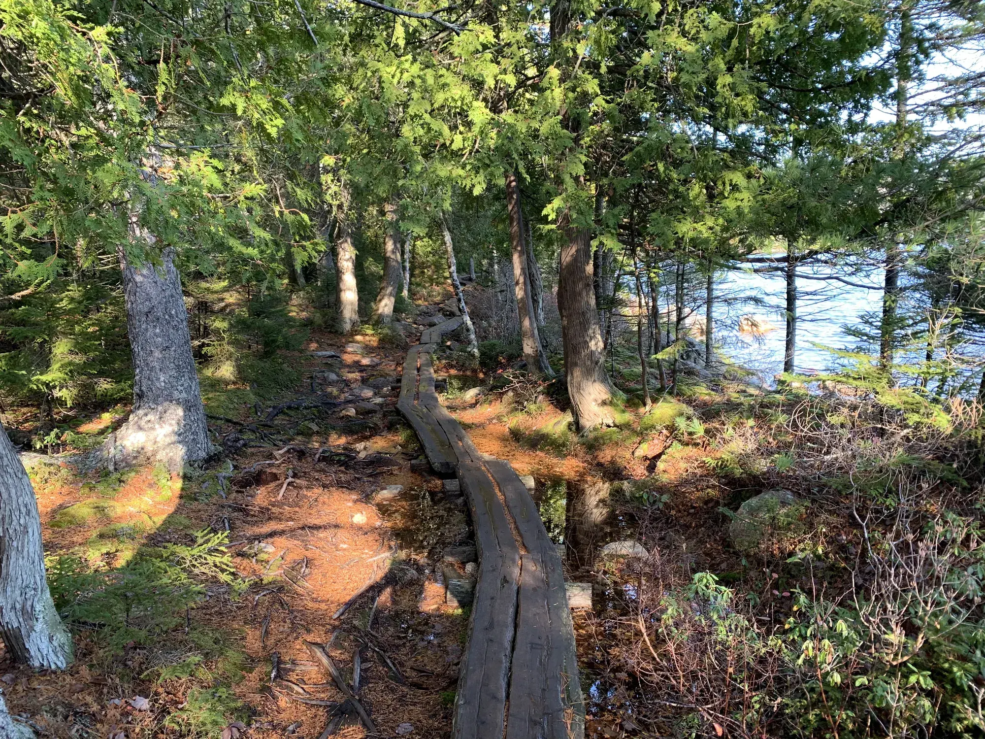
Walking the plank path through the woods beside Jordan Pond. · Nov 2019 · Our photo -
Bubbles
1.5 miles
Facts for Bubbles
A short 1.5 mile hike with views of Jordan Pond and the mountains around it from North Bubble, South Bubble, and Bubble Rock. 1
- Time
- 60-90 minutes 1
- Route
- out-and-back 1
- Trailhead
- Bubbles Divide Trailhead at The Bubbles parking lot on Park Loop Road. 1
- Season
- Spring, Summer, Fall 1
- Dogs
- Allowed with restrictions 1
- Accessibility
- The Bubbles hike is not accessible. The trails have uneven footing, stairs, and short, steep sections. There are no accessible restrooms at the trailhead. 1
-
Ship Harbor Trail
Ship Harbor Trail is a figure-8 trail covering 1.3 miles.
Facts for Ship Harbor Trail
The connected loops have different access characteristics. NPS calls the first ADA compliant but describes steps and plank trail on the second. Keep that distinction when choosing a turnaround: the full figure-eight distance is not an accessibility assessment of every section. 1
- Distance
- 1.3-mile figure-eight route (NPS). 1
- Elevation
- The NPS doesn’t publish the elevation gain. 1
- Time
- 30–60 minutes (NPS activity). 1
- Difficulty
- First loop ADA compliant; second has steps and plank trail. 1
- Season
- Spring, Summer, Fall 1
- Dogs
- Allowed with restrictions 1
- Accessibility
- The first loop is ADA compliant. Second loop is mostly flat with occasional log framed steps and plank trail. Restrooms (vault toilets) at trailhead are not accessible. In front of the restroom, one… 1
-
Bass Harbor Head Lighthouse
Bass Harbor Head Lighthouse on the southern-most tip of the island
Stay near Blackwoods Campground, subject to availability and operating season. Source
2 days
Make time for Jordan Pond Path
Add your dates and save a copy.
Day 1 · Park Loop Road from Hulls Cove → Sand Beach → Thunder Hole → Otter Cliffs → Cadillac Summit Road
Use the open-road season: most Park Loop Road access is available outside its December 1–April 14 closure; weather can delay spring opening. Access source
-
Park Loop Road from Hulls Cove
The scenic 27-mile (43 km) scenic loop begins at Hulls Cove Visitor Center
-
Sand Beach
The trail begins from the upper parking lot of Sand Beach.
Facts for Sand Beach
See a sandy ocean beach along Park Loop Road. 1
-
Thunder Hole
Thunder Hole, an underwater sea cave
-
Otter Cliffs
Arrive at Otter Cliffs, 110-ft cliffs that mark the highest point along the Ocean Path.
-
Cadillac Summit RoadPartly closed: NPS alert ↗
Cadillac Summit Road offers a three-mile drive to the top of the highest peak in the park.
Our tip From late May through October you need a vehicle reservation to drive the Cadillac Summit Road, and sunrise slots go fast, so book as soon as they open. For an off-season sunrise, bring warm layers for the wind on top. David & Keri
Stay near Blackwoods Campground, subject to availability and operating season. Source
Day 2 · Jordan Pond Path → Bubbles → Ship Harbor Trail → Bass Harbor Head Lighthouse
Use the open-road season: most Park Loop Road access is available outside its December 1–April 14 closure; weather can delay spring opening. Access source
-
Jordan Pond Path
Distance: 3.3 mile loop
Facts for Jordan Pond Path
3.3-mile loop. Eastern side is easier; western rocks, boardwalks and bridges create uneven footing. 1
- Distance
- 3.3-mile loop. 1
- Time
- 1–3 hours. 1
- Difficulty
- Eastern side is easier; western rocks, boardwalks and bridges create uneven footing. 1
- Route
- loop 1
- Trailhead
- Jordan Pond boat launch; use the North Lot off Park Loop Road. 1
- Season
- Year-round 1
- Dogs
- Allowed with restrictions 1
- Accessibility
- The Jordan Pond Path is not accessible. The trail has uneven footing, stepping stones, and a small bridge. The Jordan Pond restuarant area and boat launch are accessible. 1
-
Bubbles
1.5 miles
Facts for Bubbles
A short 1.5 mile hike with views of Jordan Pond and the mountains around it from North Bubble, South Bubble, and Bubble Rock. 1
- Time
- 60-90 minutes 1
- Route
- out-and-back 1
- Trailhead
- Bubbles Divide Trailhead at The Bubbles parking lot on Park Loop Road. 1
- Season
- Spring, Summer, Fall 1
- Dogs
- Allowed with restrictions 1
- Accessibility
- The Bubbles hike is not accessible. The trails have uneven footing, stairs, and short, steep sections. There are no accessible restrooms at the trailhead. 1
-
Ship Harbor Trail
Ship Harbor Trail is a figure-8 trail covering 1.3 miles.
Facts for Ship Harbor Trail
The connected loops have different access characteristics. NPS calls the first ADA compliant but describes steps and plank trail on the second. Keep that distinction when choosing a turnaround: the full figure-eight distance is not an accessibility assessment of every section. 1
- Distance
- 1.3-mile figure-eight route (NPS). 1
- Elevation
- The NPS doesn’t publish the elevation gain. 1
- Time
- 30–60 minutes (NPS activity). 1
- Difficulty
- First loop ADA compliant; second has steps and plank trail. 1
- Season
- Spring, Summer, Fall 1
- Dogs
- Allowed with restrictions 1
- Accessibility
- The first loop is ADA compliant. Second loop is mostly flat with occasional log framed steps and plank trail. Restrooms (vault toilets) at trailhead are not accessible. In front of the restroom, one… 1
-
Bass Harbor Head Lighthouse
Bass Harbor Head Lighthouse on the southern-most tip of the island
Stay near Blackwoods Campground, subject to availability and operating season. Source
3 days
Make time for Jordan Pond Path
Add your dates and save a copy.
Day 1 · Park Loop Road from Hulls Cove → Sand Beach → Thunder Hole → Otter Cliffs → Cadillac Summit Road
Use the open-road season: most Park Loop Road access is available outside its December 1–April 14 closure; weather can delay spring opening. Access source
-
Park Loop Road from Hulls Cove
The scenic 27-mile (43 km) scenic loop begins at Hulls Cove Visitor Center
-
Sand Beach
The trail begins from the upper parking lot of Sand Beach.
Facts for Sand Beach
See a sandy ocean beach along Park Loop Road. 1
-
Thunder Hole
Thunder Hole, an underwater sea cave
-
Otter Cliffs
Arrive at Otter Cliffs, 110-ft cliffs that mark the highest point along the Ocean Path.
-
Cadillac Summit RoadPartly closed: NPS alert ↗
Cadillac Summit Road offers a three-mile drive to the top of the highest peak in the park.
Our tip From late May through October you need a vehicle reservation to drive the Cadillac Summit Road, and sunrise slots go fast, so book as soon as they open. For an off-season sunrise, bring warm layers for the wind on top. David & Keri
Stay near Blackwoods Campground, subject to availability and operating season. Source
Day 2 · Jordan Pond Path → Bubbles
Use the open-road season: most Park Loop Road access is available outside its December 1–April 14 closure; weather can delay spring opening. Access source
-
Jordan Pond Path
Distance: 3.3 mile loop
Facts for Jordan Pond Path
3.3-mile loop. Eastern side is easier; western rocks, boardwalks and bridges create uneven footing. 1
- Distance
- 3.3-mile loop. 1
- Time
- 1–3 hours. 1
- Difficulty
- Eastern side is easier; western rocks, boardwalks and bridges create uneven footing. 1
- Route
- loop 1
- Trailhead
- Jordan Pond boat launch; use the North Lot off Park Loop Road. 1
- Season
- Year-round 1
- Dogs
- Allowed with restrictions 1
- Accessibility
- The Jordan Pond Path is not accessible. The trail has uneven footing, stepping stones, and a small bridge. The Jordan Pond restuarant area and boat launch are accessible. 1
-
Bubbles
1.5 miles
Facts for Bubbles
A short 1.5 mile hike with views of Jordan Pond and the mountains around it from North Bubble, South Bubble, and Bubble Rock. 1
- Time
- 60-90 minutes 1
- Route
- out-and-back 1
- Trailhead
- Bubbles Divide Trailhead at The Bubbles parking lot on Park Loop Road. 1
- Season
- Spring, Summer, Fall 1
- Dogs
- Allowed with restrictions 1
- Accessibility
- The Bubbles hike is not accessible. The trails have uneven footing, stairs, and short, steep sections. There are no accessible restrooms at the trailhead. 1
Stay near Blackwoods Campground, subject to availability and operating season. Source
Day 3 · Echo Lake Beach → Ship Harbor Trail → Bass Harbor Head Lighthouse
Use the open-road season: most Park Loop Road access is available outside its December 1–April 14 closure; weather can delay spring opening. Access source
-
Echo Lake Beach
swimming is allowed at Echo Lake Beach.
Facts for Echo Lake Beach
Echo Lake Beach is a popular, freshwater swimming area on the southern end of Echo Lake. It is accessible off Route 102 in Southwest Harbor. 1
-
Ship Harbor Trail
Ship Harbor Trail is a figure-8 trail covering 1.3 miles.
Facts for Ship Harbor Trail
The connected loops have different access characteristics. NPS calls the first ADA compliant but describes steps and plank trail on the second. Keep that distinction when choosing a turnaround: the full figure-eight distance is not an accessibility assessment of every section. 1
- Distance
- 1.3-mile figure-eight route (NPS). 1
- Elevation
- The NPS doesn’t publish the elevation gain. 1
- Time
- 30–60 minutes (NPS activity). 1
- Difficulty
- First loop ADA compliant; second has steps and plank trail. 1
- Season
- Spring, Summer, Fall 1
- Dogs
- Allowed with restrictions 1
- Accessibility
- The first loop is ADA compliant. Second loop is mostly flat with occasional log framed steps and plank trail. Restrooms (vault toilets) at trailhead are not accessible. In front of the restroom, one… 1
-
Bass Harbor Head Lighthouse
Bass Harbor Head Lighthouse on the southern-most tip of the island
Stay near Blackwoods Campground, subject to availability and operating season. Source
5 days
Make time for Jordan Pond Path
Add your dates and save a copy.
Day 1 · Park Loop Road from Hulls Cove → Sand Beach → Thunder Hole → Otter Cliffs
Use the open-road season: most Park Loop Road access is available outside its December 1–April 14 closure; weather can delay spring opening. Access source
-
Park Loop Road from Hulls Cove
The scenic 27-mile (43 km) scenic loop begins at Hulls Cove Visitor Center
-
Sand Beach
The trail begins from the upper parking lot of Sand Beach.
Facts for Sand Beach
See a sandy ocean beach along Park Loop Road. 1
-
Thunder Hole
Thunder Hole, an underwater sea cave
-
Otter Cliffs
Arrive at Otter Cliffs, 110-ft cliffs that mark the highest point along the Ocean Path.
Stay near Blackwoods Campground, subject to availability and operating season. Source
Day 2 · Jordan Pond Path → Bubbles
Use the open-road season: most Park Loop Road access is available outside its December 1–April 14 closure; weather can delay spring opening. Access source
-
Jordan Pond Path
Distance: 3.3 mile loop
Facts for Jordan Pond Path
3.3-mile loop. Eastern side is easier; western rocks, boardwalks and bridges create uneven footing. 1
- Distance
- 3.3-mile loop. 1
- Time
- 1–3 hours. 1
- Difficulty
- Eastern side is easier; western rocks, boardwalks and bridges create uneven footing. 1
- Route
- loop 1
- Trailhead
- Jordan Pond boat launch; use the North Lot off Park Loop Road. 1
- Season
- Year-round 1
- Dogs
- Allowed with restrictions 1
- Accessibility
- The Jordan Pond Path is not accessible. The trail has uneven footing, stepping stones, and a small bridge. The Jordan Pond restuarant area and boat launch are accessible. 1
-
Bubbles
1.5 miles
Facts for Bubbles
A short 1.5 mile hike with views of Jordan Pond and the mountains around it from North Bubble, South Bubble, and Bubble Rock. 1
- Time
- 60-90 minutes 1
- Route
- out-and-back 1
- Trailhead
- Bubbles Divide Trailhead at The Bubbles parking lot on Park Loop Road. 1
- Season
- Spring, Summer, Fall 1
- Dogs
- Allowed with restrictions 1
- Accessibility
- The Bubbles hike is not accessible. The trails have uneven footing, stairs, and short, steep sections. There are no accessible restrooms at the trailhead. 1
Stay near Blackwoods Campground, subject to availability and operating season. Source
Day 3 · Cadillac Summit Road → Echo Lake Beach → Ship Harbor Trail → Bass Harbor Head Lighthouse
Use the open-road season: most Park Loop Road access is available outside its December 1–April 14 closure; weather can delay spring opening. Access source
-
Cadillac Summit RoadPartly closed: NPS alert ↗
Cadillac Summit Road offers a three-mile drive to the top of the highest peak in the park.
Our tip From late May through October you need a vehicle reservation to drive the Cadillac Summit Road, and sunrise slots go fast, so book as soon as they open. For an off-season sunrise, bring warm layers for the wind on top. David & Keri
-
Echo Lake Beach
swimming is allowed at Echo Lake Beach.
Facts for Echo Lake Beach
Echo Lake Beach is a popular, freshwater swimming area on the southern end of Echo Lake. It is accessible off Route 102 in Southwest Harbor. 1
-
Ship Harbor Trail
Ship Harbor Trail is a figure-8 trail covering 1.3 miles.
Facts for Ship Harbor Trail
The connected loops have different access characteristics. NPS calls the first ADA compliant but describes steps and plank trail on the second. Keep that distinction when choosing a turnaround: the full figure-eight distance is not an accessibility assessment of every section. 1
- Distance
- 1.3-mile figure-eight route (NPS). 1
- Elevation
- The NPS doesn’t publish the elevation gain. 1
- Time
- 30–60 minutes (NPS activity). 1
- Difficulty
- First loop ADA compliant; second has steps and plank trail. 1
- Season
- Spring, Summer, Fall 1
- Dogs
- Allowed with restrictions 1
- Accessibility
- The first loop is ADA compliant. Second loop is mostly flat with occasional log framed steps and plank trail. Restrooms (vault toilets) at trailhead are not accessible. In front of the restroom, one… 1
-
Bass Harbor Head Lighthouse
Bass Harbor Head Lighthouse on the southern-most tip of the island
Stay near Blackwoods Campground, subject to availability and operating season. Source
Day 4 · Frazer Point → Schoodic Point → Blueberry Hill
Use the open-road season: most Park Loop Road access is available outside its December 1–April 14 closure; weather can delay spring opening. Access source
-
Frazer Point
Next you will pass the Frazer Point Picnic Area
-
Schoodic Point
Arey Cove Road leads to Schoodic Point
-
Blueberry Hill
Blueberry Hill Parking Area, about one mile beyond Schoodic point.
Stay near Schoodic Woods Campground for the mainland day; check operating season and reserve in advance. Source
Day 5 · Jordan Pond → Jordan Pond Path
Use the open-road season: most Park Loop Road access is available outside its December 1–April 14 closure; weather can delay spring opening. Access source
-
Jordan Pond
Jordan Pond is bordered by Penobscot, Pemetic, and two rounded peaks known as the Bubbles.
-
Jordan Pond Path
Distance: 3.3 mile loop
Facts for Jordan Pond Path
3.3-mile loop. Eastern side is easier; western rocks, boardwalks and bridges create uneven footing. 1
- Distance
- 3.3-mile loop. 1
- Time
- 1–3 hours. 1
- Difficulty
- Eastern side is easier; western rocks, boardwalks and bridges create uneven footing. 1
- Route
- loop 1
- Trailhead
- Jordan Pond boat launch; use the North Lot off Park Loop Road. 1
- Season
- Year-round 1
- Dogs
- Allowed with restrictions 1
- Accessibility
- The Jordan Pond Path is not accessible. The trail has uneven footing, stepping stones, and a small bridge. The Jordan Pond restuarant area and boat launch are accessible. 1
Stay near Blackwoods Campground, subject to availability and operating season. Source
Good to know
For your days in Acadia
Wildlife and where to look (5)
- Beaver. Jordan Pond; dawn or dusk. Look from the path; never leave the trail to approach a lodge. nps.gov
- White-tailed deer. Great Meadow, north of Sieur de Monts along Jesup Path. Watch the meadow from Jesup Path. nps.gov
- Painted turtle. Ponds along Witch Hole Pond Loop carriage road. Look for turtles sunning on rocks. nps.gov
- Peregrine falcon. Cliffs above the Precipice Trailhead; spring and early summer nesting season; recurring NPS guidance checked November 2026. Bring binoculars; respect nesting closures. nps.gov
- Common loon. Jordan Pond. Scan the water while walking the shoreline path. nps.gov
Night sky and light (3)
- Ocean Path (Coast between Sand Beach and Otter Point). Start at upper Sand Beach parking lot; uneven surfaces and stairs beyond Thunder Hole. NPS identifies this trail as a sunrise viewing location. nps.gov
- Sand Beach (Sand Beach, Park Loop Road). Night visits allowed; camping and overnight parking prohibited. Bring warm layers; avoid entering the water at night. nps.gov
- Jordan Pond (Shoreline near Jordan Pond House). Park in the North Lot and walk to the boat launch; no public transportation after dark. The eastern shoreline offers night-sky photography viewpoints. nps.gov
Longer drives between areas (4)
- Hulls Cove Visitor Center to Schoodic Peninsula: about 1 hour. Separate mainland section of the park. nps.gov
- Schoodic Point to Blueberry Hill parking area: 1 miles, . Approximately one mile; follow the one-way road. nps.gov
- Blueberry Hill parking area to Wonsqueak Harbor park boundary: 2 miles, . Approximately two miles along the park road. nps.gov
- Cadillac Summit Road entrance to Cadillac Mountain summit: 3 miles, . RVs and trailers prohibited. nps.gov
Add a guided tour to your Acadia days
Affiliate link: we may earn a commission, at no extra cost to you. How this works
Affiliate link: we may earn a commission, at no extra cost to you. How this works
Before you go
- Acadia permits and reservations: lotteries, campground and lodging booking windows.
- Best time to visit Acadia: crowds, weather and seasonal access by month.
- Plan Acadia in the trip planner: your dates, booking deadlines and a conditions check before you leave.
- Is Acadia open today? Live NPS alerts and closures.
Plans checked against official NPS pages Nov 20, 2026.