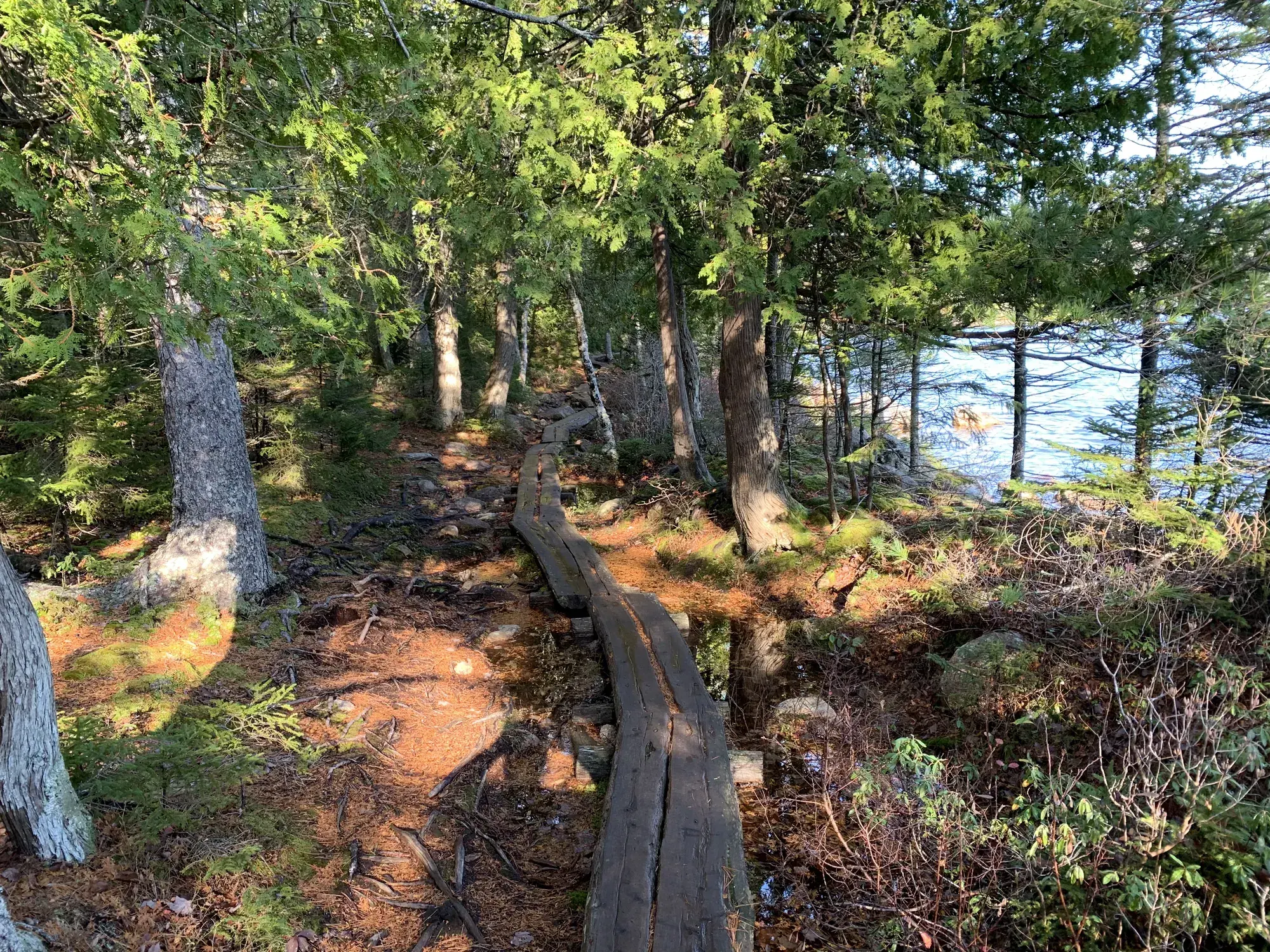
Jordan Pond Path
3.3-mile loop. Eastern side is easier; western rocks, boardwalks and bridges create uneven footing.
Acadia · Photo: David & Keri New
- 3.3 miDistance
- 1–3 hrTime
The numbers, with sources
Distance: 3.3-mile loop. Source
Gain: The NPS doesn’t publish a total climb. Source
Time: 1–3 hours. Source
Difficulty: Eastern side is easier; western rocks, boardwalks and bridges create uneven footing. Source
Trailhead: Jordan Pond boat launch; use North Lot near Jordan Pond House or Island Explorer to Jordan Pond House. Source
Route type: loop Source
Built from official sources (checked Nov 3, 2026). Confirm current conditions with the park.
Recreation.gov permits, entrances & campgrounds
Recreation.gov (RIDB). Booking records date not published. NPS guidance above takes precedence. A listing doesn’t mean you need a permit or that there’s space on your dates.
Nearby campground records
Within 10 straight-line miles of the trailhead. Distances are straight-line from map coordinates, not driving distances.
- BLACKWOODS CAMPGROUND: approximately 2.4 miles straight line. RIDB coordinates · Mapped route source
- SEAWALL CAMPGROUND: approximately 6.3 miles straight line. RIDB coordinates · Mapped route source
Park campground options (4)
These records belong to the park’s NPS recreation area. We haven’t checked how close these are to the trail, when they open or whether sites are free; check the map and the booking page.
BLACKWOODS CAMPGROUND — Campground; RIDB reservable: yes. Season: not published in structured RIDB data. Recreation.gov (RIDB) source · Booking details
NPS reservation guidance: Ninety percent of campsites are released six months in advance on the first of each month at 10 am EST. The remaining 10 percent are released at 10 am 14 days ahead of a desired arrival date on a rolling basis. All campsite reservations must be made in advance at Recreation.gov. Reservations cannot be made through the campground office or in-person. NPS source
SEAWALL CAMPGROUND — Campground; RIDB reservable: yes. Season: not published in structured RIDB data. Recreation.gov (RIDB) source · Booking details
NPS reservation guidance: Ninety percent of campsites are released six months in advance on the first of each month at 10 am EST. The remaining 10 percent are released at 10 am 14 days ahead of a desired arrival date on a rolling basis. All campsite reservations must be made in advance at Recreation.gov. Reservations cannot be made through the campground office or in-person. NPS source
DUCK HARBOR CAMPGROUND — Campground; RIDB reservable: yes. Season: not published in structured RIDB data. Recreation.gov (RIDB) source · Booking details
NPS reservation guidance: Reservations are required to camp at Duck Harbor Campground. Reservations are available 7 months in advance of the reservation date. All reservations are released at 10 am April 1 for the entire season. NPS source
Schoodic Woods Campground — Campground; RIDB reservable: yes. Season: not published in structured RIDB data. Recreation.gov (RIDB) source · Booking details
NPS reservation guidance: Ninety percent of campsites are released six months in advance on the first of each month at 10 am EST. The remaining 10 percent are released at 10 am 14 days ahead of a desired arrival date on a rolling basis. All campsite reservations must be made in advance at Recreation.gov. Reservations cannot be made through the campground office or in-person. NPS source
Route, junction by junction
Boat launch → eastern shoreline
Turn right from the boat launch and follow the east shore past the Bubbles Trail and Jordan Pond Carry junctions, staying on the Jordan Pond Path. Source
Northern end → western shore or retrace
Pass the Bubbles Divide Trailhead and the log bridges. Going back along the east side is the easier choice; the full 3.3-mile loop carries on past the Deer Brook Trail onto rocky footing. Source
Western shore → courtyard → start
Cross the boulders and the raised plank boardwalk. After the small stone bridge, turn left into the courtyard and follow the shore to the trailhead. Source
No elevation profile: we only draw one from a mapped route we can verify. Route source
In-depth guide
Compiled from linked sources, checked Nov 3, 2026. Each paragraph links to its source.
Decisions & preparation
We only show distances between points where the NPS publishes them. We don’t split the total into made-up segments. Source
Turnaround & return planning
If the group is tired or the west-side boulders look like too much, turn around at the north end and go back along the east shore. Planning basis
Parking & transport timing
Start at the Jordan Pond boat launch. Park in the North Lot near Jordan Pond House or take the Island Explorer to Jordan Pond House. The NPS doesn’t say when the lot fills or give a last bus time. Source
What to bring by season
Any season: the NPS Ten Essentials (navigation, sun protection, extra clothing, a light, first aid, fire supplies where allowed, repair tools, extra food, water and emergency shelter). Tell someone your route and when you’ll be back. Source
Warm weather: sun protection, plenty of water and extra food. Cold or wet weather: warm layers and rain gear, plus an extra layer in case you’re out longer than planned. Source
Check the weather and trail conditions before you go; we don’t know if the trail is open today. Source
Children & mobility
The Jordan Pond Path isn’t accessible: it has uneven footing, stepping stones and a small bridge. The Jordan Pond restaurant area and boat launch are accessible. Source
Is this hike for you?
The Jordan Pond Path is a 3.3-mile loop around Jordan Pond, in a steep glacier-carved valley ringed by Penobscot, Pemetic and the two rounded peaks called the Bubbles. Listen for loons, look for signs of beaver, and watch the granite cliffs for nesting peregrine falcons. The two halves are very different: the east shore is easy, while the west is significantly harder and may be challenging for families with small children, seniors and people with mobility impairments. The NPS suggests one to three hours. Source
Start on the east side so you can turn around if the loop looks like too much. Going back the way you came is a shorter hike than the full loop, so don’t count on the 3.3 miles. Source
The trail
From the boat launch, turn right along the east shore. The path is even, with crushed stone underfoot, but watch your step on the stepping stones and bridges where water runs down from the slope. About two-thirds of the way along, you pass the Bubbles Trail (to South Bubble and Bubble Rock) and Jordan Pond Carry. The north end of the pond is marked by the Bubbles Divide Trailhead, the Jordan Pond Buoy and, a little farther on, two wooden log bridges. Source
From the bridges the path heads into the forest and soon passes the Deer Brook Trail, which crosses the Eagle Lake/Jordan Pond carriage road toward Sargent Peak and Penobscot Peak. Then comes an open area of boulders that fell from the cliffs above. It’s mostly level, but there are stepping stones and uneven footing, and you may have to scramble, so take care on the rocks. After that a raised wooden plank boardwalk runs through the forest (stay on it to protect the plants), then a short forest stretch leads to a small stone bridge on the carriage road. Turning right follows the carriage road toward the Jordan Stream Path. To finish the loop, turn left into the small stone courtyard and follow the shore back to the trailhead. Source
Other trails branch off along the way. The NPS asks you to check their difficulty and elevation profiles before taking one; none of them is a shortcut, and they aren’t part of the 3.3 miles. Source
Getting to the trailhead
The trailhead is the Jordan Pond Boat Launch. By car, leave ME Route 3 at the Hulls Cove Entrance to Acadia National Park and the Hulls Cove Visitor Center and follow the Park Loop Road. At 2.8 miles keep straight on the two-way section, following signs for Jordan Pond. Park in the North Lot on the right just before the Jordan Pond House and walk down the boat access to the pond, where the trail crosses the launch. You can hike the loop in either direction. Source
By bus, take the fare-free Island Explorer to Jordan Pond House and check the schedule for routes and times. Neither the lot nor the bus is a guaranteed ride back at a set time. Source
Rules
Jordan Pond is a public water supply, so swimming and wading are banned at all times, even for a quick photo. Source
Dogs must be on a leash no longer than 6 feet. Source
Kids, strollers and wheelchairs
The NPS says the Jordan Pond Path isn’t accessible: it has uneven footing, stepping stones and a small bridge. The restaurant area and boat launch are accessible. The NPS doesn’t give a minimum age, and the crushed-stone east side isn’t rated for strollers, but it warns that the west half may be hard for families with small children. Source
Elevation profile
The elevation chart follows the mapped east and west sections of the path. Their south ends are about seventeen meters apart near the bridge, and that short join is approximate. It’s terrain context only and says nothing about the bridge or the footing. Source
Sources & planning limits
Reviewed 2026-11-03. Check current conditions for your trip dates.
- We haven’t verified complete measurements for the elevation profile. Source
- NPS details are as of the date shown. Confirm access, services and reservations for your travel date. Source
- We haven’t checked the elevation figures against each other, and we don’t use them to judge the total climb or accessibility. Source
Getting there and back
Jordan Pond boat launch; use North Lot near Jordan Pond House or Island Explorer to Jordan Pond House. Source
Return: Finish left after the small stone bridge through the courtyard and along the shore to the starting trailhead. Source
Water
The NPS listing shows no drinking water on the route. Source
The NPS listing shows no drinking water on the route. Source
Hazards
Western half may challenge small children, seniors and visitors with mobility impairments. Source
Season
Check actual weather and trail conditions before travel; no live opening status is asserted. Source
Check actual weather and trail conditions before travel; no live opening status is asserted. Source
Gear & rules
Do not swim or wade: Jordan Pond is a public water supply. Source
Filling a gap in your kit? Compare these packing essentials on Amazon. Choose gear for your route, conditions and the park’s guidance.
As an Amazon Associate we earn from qualifying purchases. How this works
Do not swim or wade: Jordan Pond is a public water supply. Source
Questions
Which route does the distance describe?
3.3-mile loop. Source
Does the accessibility review cover the whole trail?
No. The activity distinguishes walking-route terrain and accessibility from nearby facilities. Source
Alternatives
More Acadia trail guides
- Beehive Loop1.4 mi · Strenuous
- Cadillac North Ridge4.4 mi · Moderate
- Gorham Mountain Loop3.5 mi
- Great Head1.7 mi · Easy
- Ocean Path2.2 mi one way
- Precipice Loop3.2 mi · Strenuous
- Ship Harbor1.3 mi