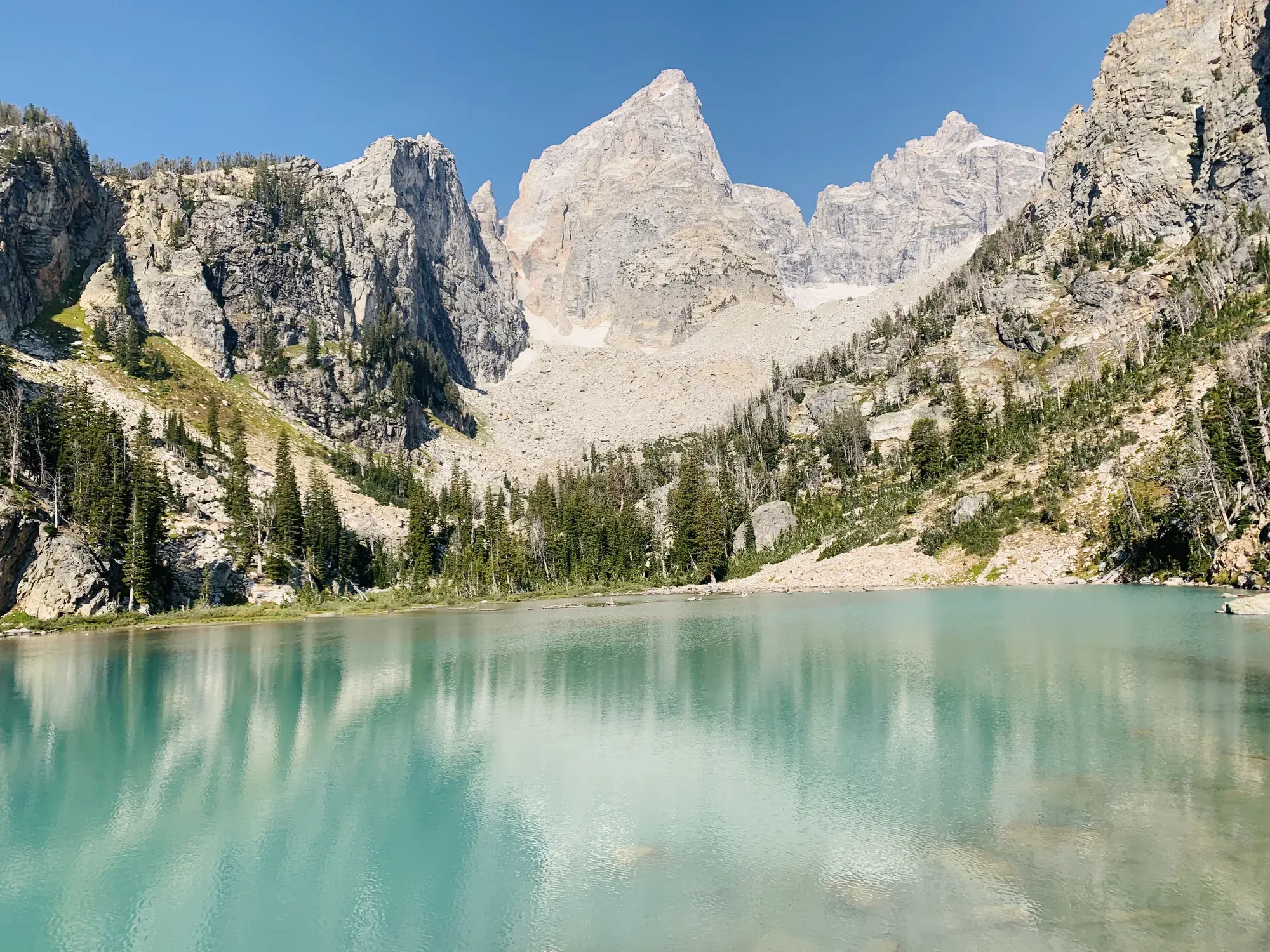
Forks of Cascade Canyon
Cascade Canyon follows Cascade Creek between Teewinot and Mount St. John. NPS describes a 9.4-mile round-trip route using the Jenny Lake shuttle boat and a longer walking approach around South Jenny Lake.
Grand Teton · Photo: David & Keri New
- 9.4 miDistance
- 1,480 ftElevation gain
- 5–9 hrTime
- EasyDifficulty
The numbers, with sources
Distance: 9.4 miles round trip via shuttle boat; 13.3 miles round trip via South Jenny Lake Loop Trail Source
Gain: 1,480 feet via shuttle boat; 1,720 feet via South Jenny Lake Loop Trail Source
Time: 5–9 hours Source
Difficulty: Moderately strenuous via shuttle boat; strenuous via South Jenny Lake Loop Trail. Source
Trailhead: South Jenny Lake Source
Route type: out-and-back Source
Built from official sources (checked Nov 3, 2026). Confirm current conditions with the park.
Recreation.gov permits, entrances & campgrounds
Recreation.gov (RIDB). Booking records date not published. NPS guidance above takes precedence. A listing doesn’t mean you need a permit or that there’s space on your dates.
Nearby campground records
Within 10 straight-line miles of the trailhead. Distances are straight-line from map coordinates, not driving distances.
- Signal Mountain Campground: approximately 8.2 miles straight line. RIDB coordinates · Mapped route source
- Jenny Lake Campground: approximately 1.5 miles straight line. RIDB coordinates · Mapped route source
Park campground options (9)
These records belong to the park’s NPS recreation area. We haven’t checked how close these are to the trail, when they open or whether sites are free; check the map and the booking page.
Signal Mountain Campground — Campground; RIDB reservable: yes. Season: not published in structured RIDB data. Recreation.gov (RIDB) source · Booking details
NPS reservation guidance: Campsites are reservable on Recreation.gov. Plan ahead and reserve your site up to six months in advance. NPS source
Lizard Creek Campground — Campground; RIDB reservable: yes. Season: not published in structured RIDB data. Recreation.gov (RIDB) source · Booking details
NPS reservation guidance: Campsites are reservable on Recreation.gov. Plan ahead and reserve your site up to six months in advance. NPS source
Headwaters Campground at Flagg Ranch — Campground; RIDB reservable: yes. Season: not published in structured RIDB data. Recreation.gov (RIDB) source · Booking details
NPS reservation guidance: All campsites in the Headwaters Campground can be reserved. The maximum stay permitted at Headwaters Campground is 14 nights, and the maximum cumulative stay between all Grand Teton National Park campgrounds is 30 nights. NPS source
Jenny Lake Campground — Campground; RIDB reservable: yes. Season: not published in structured RIDB data. Recreation.gov (RIDB) source · Booking details
NPS reservation guidance: Campsites are reservable on Recreation.gov. Plan ahead and reserve your site up to six months in advance. The maximum stay permitted at Jenny Lake Campground is seven nights, and the maximum cumulative stay between all Grand Teton National Park campgrounds is 30 nights. NPS source
Gros Ventre Campground — Campground; RIDB reservable: yes. Season: not published in structured RIDB data. Recreation.gov (RIDB) source · Booking details
NPS reservation guidance: Campsites are reservable on Recreation.gov. Plan ahead and reserve your site up to six months in advance. The maximum stay permitted at Gros Ventre Campground is 14 nights, and the maximum cumulative stay between all Grand Teton National Park campgrounds is 30 nights. NPS source
Colter Bay Tent Village — Campground; RIDB reservable: yes. Season: not published in structured RIDB data. Recreation.gov (RIDB) source · Booking details
NPS reservation guidance: Tent Cabins are reservable on Recreation.gov. Plan ahead and reserve your site up to six months in advance. NPS source
Colter Bay Marina End Ties — Campground; RIDB reservable: yes. Season: not published in structured RIDB data. Recreation.gov (RIDB) source · Booking details
Colter Bay Campground — Campground; RIDB reservable: yes. Season: not published in structured RIDB data. Recreation.gov (RIDB) source · Booking details
NPS reservation guidance: Campsites are reservable on Recreation.gov. Plan ahead and reserve your site up to six months in advance. The maximum stay permitted at Colter Bay campground is 14 nights, and the maximum cumulative stay between all Grand Teton National Park campgrounds is 30 nights. NPS source
Colter Bay RV Park — Campground; RIDB reservable: yes. Season: not published in structured RIDB data. Recreation.gov (RIDB) source · Booking details
NPS reservation guidance: All campsites in the Colter Bay RV Park can be reserved. The maximum stay permitted at Colter Bay RV Park is 14 nights, and the maximum cumulative stay between all Grand Teton National Park campgrounds is 30 nights. NPS source
Route, junction by junction
West Jenny Lake boat landing → First Cascade Creek bridge
The approach to the first bridge provides a view of Cascade Creek and its cascading waterfalls. NPS describes the approach as fairly level with a set of stone steps gaining 65 feet over 0.2 mile. The page doesn’t give the full distance or elevation gain from the west boat landing to the bridge. Source
First Cascade Creek bridge → Hidden Falls
From the west side of Jenny Lake, the trail gently slopes up toward Hidden Falls. NPS describes the falls as a 100-foot cascade fed by snowmelt. The trail surface includes dirt, rock steps and obstacles such as roots and rocks; the published 200-foot rise describes the west-side approach as a whole, not just the section after the first bridge. Source
Hidden Falls → Inspiration Point
From Hidden Falls, continue uphill toward Inspiration Point. The Cascade Canyon page describes multiple sets of stone steps and a bridge on the approach from the lakeshore. The last steps to Inspiration Point are exposed and have no stair rail or handholds. Source
Distance: 0.5 mile beyond Hidden Falls Source
Inspiration Point → Forks of Cascade Canyon
Beyond Inspiration Point, the trail continues into a glacially carved U-shaped canyon between Teewinot and Mount St. John. Follow Cascade Creek through a gradual climb interrupted by small stream crossings, rock slides and many ups and downs. NPS describes views of Grand Teton, Mount Owen and Teewinot, with opportunities to see moose, bears and alpine wildlife such as pika. The trail continues several miles before splitting; NPS explicitly allows choosing an earlier turning point. Source
Elevation: Beyond Inspiration Point, gradually climbs over 500 feet with numerous ups and downs Source
No elevation profile: we only draw one from a mapped route we can verify. Route source
In-depth guide
Compiled from linked sources, checked Nov 3, 2026. Each paragraph links to its source.
Decisions & preparation
We only show distances between points where the NPS publishes them. We don’t split the total into made-up segments. Source
Turnaround & return planning
Turn back before the group runs low on energy, water or daylight. Going back the way you came is the plan; don’t count on a pickup. Planning basis
Parking & transport timing
Decide on the Jenny Lake shuttle boat or the walk around South Jenny Lake before you start: 9.4 miles round trip by boat, 13.3 miles on the South Jenny Lake Loop Trail. Check boat hours and prices; the NPS doesn’t give departure times or when the lot fills. Source
The boat shortens the walk. Check its hours and the last return before you go; the NPS page doesn’t give pickup times. Shuttle source
What to bring by season
Any season: the NPS Ten Essentials (navigation, sun protection, extra clothing, a light, first aid, fire supplies where allowed, repair tools, extra food, water and emergency shelter). Tell someone your route and when you’ll be back. Source
Warm weather: sun protection, plenty of water and extra food. Cold or wet weather: warm layers and rain gear, plus an extra layer in case you’re out longer than planned. Source
The NPS lists summer and fall for Cascade Canyon, but snow often lasts until early to mid-summer, and Hidden Falls can hold slick snow all spring. There’s no guaranteed snow-free date. Source
Parkwide, the NPS says valley trails are usually snow-free by mid-June, while mountain trails and passes can stay snowy until late July. Check current conditions for Cascade Canyon itself. Source
Children & mobility
Forks of Cascade Canyon by shuttle boat: moderately strenuous, 9.4 mi (15.1 km) round trip out and back, 1,480 ft (450 m) of climbing, average slope 9%. By the South Jenny Lake Loop Trail: strenuous, 13.3 mi (21.4 km) round trip, 1,720 ft (520 m) of climbing, average slope 9%. The walk to the first bridge, with a view of the falls on Cascade Creek, is fairly level apart from stone steps that gain 65 ft over 0.2 mi (0.3 km). The trail to Inspiration Point has several sets of stone steps and a bridge, and the last, exposed set has no rail or handholds. Past Inspiration Point it climbs gradually over 500 ft with lots of ups and downs, crossing small streams and rock slides on crushed rock and dirt. Source
Is this hike for you?
Cascade Canyon starts across Jenny Lake. The Jenny Lake boat runs between the East Shore Boat Dock and the West Shore Boat Dock, and you can ride it one way or round trip to cut the walking. Pick your boat plan before you start so everyone knows how much is left on foot. Source · Source 2
Both ways in average a 9% slope, but that hides stone steps, exposed spots, stream crossings and rock slides. The descent comes on tired legs, which matters most with kids or anyone unsteady on rough ground. Source
The trail
At the forks, the North Fork heads to Lake Solitude and the South Fork to Schoolroom Glacier and Hurricane Pass. Both are big additions, so pick one before you get there, or make the forks your turnaround. The NPS says you can turn back anywhere along the canyon, which is a fine plan if energy, water or weather run short. Source · Source 2
Getting to the trailhead
The Jenny Lake lot is often full from 9 a.m. to 4 p.m. Give yourself time to find parking and walk to the dock before the boat you want, and have a backup if the lot is full. Source
Teton Park Road closes between Taggart Lake Trailhead and Signal Mountain Lodge from November 1 through April 30, so the usual drive to Jenny Lake isn’t open in winter. Road reports can lag and miss short closures, and winter brings packed snow, ice and whiteouts. Check the latest report, then follow the signs on the road. Source
Weather and water
Afternoon thundershowers are common in July and August, and snow or frost can happen in any month. Check the mountain forecast, carry layers and rain gear, and leave time to get back before a storm. Source
In lightning, stay off mountaintops, ridges, open ground and away from lone trees. A forest of trees the same height is safer, but don’t stand on tree roots, and no place outdoors is completely safe. Source
Glacial lakes and the Snake River often stay below 60°F even in summer, and cold-water hypothermia comes on fast. Watch for slippery rocks, sudden drop-offs and strong currents, and keep kids close at the water’s edge. Source
Water and food
Water is available at the developed Jenny Lake area when it’s operating. Treat any water from the canyon’s lakes and streams, which can carry Giardia: boil it for three to five minutes, or use tablets or an approved filter. Keep food and packs with you at every stop so animals can’t get into them. Source
Wildlife and emergencies
Stay at least 100 yards from bears and wolves and 25 yards from other wildlife. Never get between a mother and her young, and don’t approach, chase or feed animals. If a moose or bear is on the trail, wait or back off. Source
If you need to send for help, give the exact spot on a map, the injuries, the gear you have and any treatment given, and stay with the injured person if you can. Backcountry rescue isn’t guaranteed. Source
Camping overnight
About one third of backcountry permits can be reserved in advance and two thirds are walk-up. A reservation still has to be picked up in person, starting the day before your trip, and it can be cancelled after 10 a.m. on your start day if you don’t pick it up or call the office. Source · Source 2
Individual permits cover up to six people; groups of seven to twelve need group sites. Fees are a $20 nonrefundable permit charge plus $7 per person per night, on top of park entrance. Camp only where your permit says. Source
The permit holder is the trip leader and has to be on the whole trip. You can name an alternate when you reserve, but you can’t change them after you pay. Source
Sources & planning limits
Reviewed 2026-11-03. Check current conditions for your trip dates.
Getting there and back
Choose the Jenny Lake shuttle boat or the South Jenny Lake walking approach before starting. NPS lists 9.4 miles round trip via boat and 13.3 miles via South Jenny Lake Loop Trail. The activity tells visitors to check boat hours and prices; exact departures and parking-fill times are not supplied. Source
Shuttle: The boat shortens the approach; confirm its operating hours and return arrangements before departure. The NPS page doesn’t give an exact pickup time. Source
Return: Return along the same hiking route to the west shore for a round-trip boat itinerary. NPS also publishes a 13.3-mile round-trip walking itinerary via South Jenny Lake Loop Trail, compared with 9.4 miles using the boat. Check the operator’s hours before committing to the shuttle option; the published 2026 operating season ended September 30. The opened homepage does not publish a separate west-dock final departure or missed-boat procedure. Source
Water
Carry drinking water. Grand Teton’s hiking guidance warns that dehydration is common and can be serious, and advises extra water when hiking at high elevation. The trail pages describe Cascade Creek and small streams but do not identify those as potable-water supplies or promise a drinking-water tap along the route. Source
Hazards
Exposed stone steps
The final set of steps to Inspiration Point is exposed, with no stair rail or handholds. This is part of the approach to Cascade Canyon, even though much of the canyon beyond climbs gradually. Source
Snow and spring conditions
Snow often lingers in Cascade Canyon until early to mid-summer. Check conditions before a spring attempt; NPS says not to attempt the canyon over snow without previous snow experience and proper equipment. Source
Bears and other wildlife
Black and grizzly bears live throughout Grand Teton. General park hiking guidance recommends making noise, traveling in groups of three or more, and carrying bear spray that you know how to use. Moose, bears and pika are among the animals NPS mentions for this canyon. Source
High elevation and weather
High elevation can cause breathing difficulties, and sudden weather changes are a concern. NPS recommends pacing yourself, carrying extra water, bringing rain gear and extra layers, and telling someone the route and expected return time. Source
Season
The shuttle’s published 2026 season ended September 30; the operator confirms it is closed for 2026 and expects to return in May 2027. Source
NPS lists summer and fall for Cascade Canyon but warns that snow often remains until early to mid-summer. Hidden Falls can hold snow through spring and be slick. These statements describe typical conditions rather than a guaranteed snow-free date. Source
For the park generally, NPS says valley trails become snow-free by mid-June while mountain trails and passes may remain snowy until late July. Do not substitute that general calendar for a current report on Cascade Canyon. Source
Gear & rules
Pets are not allowed. Source
Filling a gap in your kit? Compare these packing essentials on Amazon. Choose gear for your route, conditions and the park’s guidance.
As an Amazon Associate we earn from qualifying purchases. How this works
Pets, bicycles and vehicles are not allowed on trails or in the backcountry. Stay on the trail to prevent erosion and carry out all garbage. Source
Carry a topographic map for backcountry hiking. NPS discourages solo hiking, off-trail hiking and trail running, and strongly discourages headphones. Rain gear and extra layers are recommended for rapid weather changes. Source
Day-hike reservations are not required on the Cascade Canyon activity page. All overnight camping in Grand Teton’s backcountry requires a permit; the day-hike reservation statement does not authorize an overnight stay. Source
When stock passes, give it right of way by stepping off the trail on the uphill side and waiting quietly. NPS includes horses, mules, burros and llamas in this instruction. Source
Pace
NPS publishes 5–9 hours for the Forks of Cascade Canyon activity. It lists both the 9.4-mile boat-assisted and 13.3-mile walking approaches on that page without giving separate per-stretch time budgets. Source
Questions
Is the boat required?
No. NPS publishes a 13.3-mile round trip via South Jenny Lake Loop Trail with 1,720 feet of gain. Using the shuttle boat gives a 9.4-mile hiking round trip with 1,480 feet of gain. The boat option is moderately strenuous; the longer walk is strenuous. Source
Must every visitor go all the way to the forks?
No. NPS says visitors can choose a turning point at any time and make the canyon walk as long or short as desired. That flexibility does not supply a published mileage for an arbitrary turnaround. Source
Where are boat tickets purchased?
NPS says tickets are purchased directly at the boat dock and advises checking the operator’s hours and prices before using the shuttle. The operator’s homepage says reservations are not required. Source
How should visitors plan for parking?
NPS warns that Jenny Lake is popular and fills in mid-summer; its trail page advises arrival before 9 am. If parking along the shoulder, pull completely off the road. General park guidance says not to park on natural vegetation and to be flexible about alternate hikes. Source
Is this a smooth accessible path?
The published average slope is 9 percent for both Forks itineraries, but the route also has stone steps, exposed sections, stream crossings and rock slides. The canyon surface is crushed rock and dirt. The average slope does not describe every individual stretch. Source
What formed Cascade Canyon?
NPS describes it as a glacially carved U-shaped canyon between Teewinot and Mount St. John. Source
Does the trail become level after Inspiration Point?
Beyond Inspiration Point it gradually climbs over 500 feet, crossing small streams and rock slides with numerous ups and downs. The trail surface is crushed rock and dirt. Source
Alternatives
Hidden Falls: Easy 1-mile round-trip hike using the shuttle boat, with 300 feet of gain. Without the boat, NPS lists 4.9 miles round trip and moderate difficulty. Source
Camp near Forks of Cascade Canyon
Closest campgrounds by drive time to Jenny Lake Loop Trailhead:
- 2 min Jenny Lake (0.4 mi, in the park)
- 19 min Signal Mountain (10.5 mi, in the park)
- 33 min Gros Ventre (18.3 mi, in the park)
- 37 min Colter Bay (19.6 mi, in the park)
- 37 min Colter Bay RV Park (19.6 mi, in the park)
Driving time with no traffic (OSRM, OpenStreetMap roads). Some park roads are shuttle-only in season. All camping near Grand Teton
More Grand Teton trail guides
- Hidden Falls via Jenny Lake Shuttle Boat1 mi · Moderate
- Jenny Lake Loop7.1 mi
- String Lake3.7 mi · Easy
- Taggart Lake Trail3 mi · Easy