
RedwoodItinerary
Redwood itinerary
Free 1-, 2-, and 3-day Redwood plans with grove walks, coastal stops, and road and permit checks.
By David & Keri New, who have visited 63 of the 64 U.S. national parks
Redwood · Photo: David & Keri New
Choose your days
Start in Jedediah Smith with Boy Scout Tree Trail and Stout Grove. Add Prairie Creek on day two. On day three, choose Fern Canyon and Gold Bluffs Beach or a southern grove if road access or permits favor that option.
David and Keri’s favorite: Boy Scout Tree Trail.
Times are suggested local starts. Closure flags update from the NPS alert feed when available. Check conditions again before your visit. Check park alerts
Open the free one-page planner
1 day
Make time for Boy Scout Tree Trail
Add your dates and save a copy.
Day 1 · Boy Scout Tree Trail and Stout Memorial Grove
Check Howland Hill Road after storms. The narrow dirt road is unsuitable for motorhomes or trailers. If the road is closed or your vehicle cannot use it, try Simpson-Reed Trail off US 199 if open. Reach Stout Grove from its own trailhead and avoid relying on seasonal river bridges. Access source
2 stops in order. Positions from OpenStreetMap; map data loads from OpenStreetMap when you tap. Not for navigation.
-
Boy Scout Tree Trail
Arrive early for limited trailhead parking. Follow the old-growth route to the Boy Scout Tree spur and Fern Falls if conditions allow. Allow up to five hours for the 5.5-mile round trip.
Our tip For the Boy Scout Tree Trail, get there early if you’re going on a weekend. The parking area at the trailhead fills up really quick. David & Keri
Facts for Boy Scout Tree Trail
A moderate hike with some steep grades and switchbacks. 1
- Time
- 3-5 hours 1
- Route
- out-and-back 1
- Trailhead
- Boy Scout Tree Trailhead; 3.5 miles east along Howland Hill Road from Elk Valley Road. 1
- Season
- Year-round 1
- Dogs
- Not allowed 1
- Accessibility
- This is not an ADA accessible trail. It is composed of wood and aggregate and it ranges 4-6 feet wide. It climbs a couple of hundred feet with switchbacks. Service pets are welcome. 1
-
Stout Memorial Grove
If Howland Hill Road and the trailhead are accessible, use the short grove loop from the Stout parking lot. Leave it for another visit if the lot is full or the road is unsuitable.
Facts for Stout Memorial Grove
See old-growth redwoods beside the Smith River. 1
- Time
- 1-2 hours 1
- Trailhead
- Stout Memorial Grove Trailhead; approach from the eastern section of Howland Hill Road. 1
- Where
- Jedediah Smith Redwoods State Park 1
- Walking
- 0.5 mi trail; river access spur 1
- Season
- Year-round via Howland Hill Road, conditions permitting. 1
- Dogs
- Not allowed 1
- Accessibility
- This is not an ADA accessible trail. It is composed of wood and aggregate material and it ranges from 4-6 feet wide. Trail has switchbacks to access the river. Service pets are welcome. 1
Stay near Crescent City or Hiouchi for Jedediah Smith Redwoods State Park. Check campground availability if you want to stay inside the parks. Source
2 days
Make time for Boy Scout Tree Trail
Add your dates and save a copy.
Day 1 · Boy Scout Tree Trail and Stout Memorial Grove
Check Howland Hill Road after storms. The narrow dirt road is unsuitable for motorhomes or trailers. If the road is closed or your vehicle cannot use it, try Simpson-Reed Trail off US 199 if open. Reach Stout Grove from its own trailhead and avoid relying on seasonal river bridges. Access source
2 stops in order. Positions from OpenStreetMap; map data loads from OpenStreetMap when you tap. Not for navigation.
-
Boy Scout Tree Trail
Arrive early for limited trailhead parking. Follow the old-growth route to the Boy Scout Tree spur and Fern Falls if conditions allow. Allow up to five hours for the 5.5-mile round trip.
Our tip For the Boy Scout Tree Trail, get there early if you’re going on a weekend. The parking area at the trailhead fills up really quick. David & Keri
Facts for Boy Scout Tree Trail
A moderate hike with some steep grades and switchbacks. 1
- Time
- 3-5 hours 1
- Route
- out-and-back 1
- Trailhead
- Boy Scout Tree Trailhead; 3.5 miles east along Howland Hill Road from Elk Valley Road. 1
- Season
- Year-round 1
- Dogs
- Not allowed 1
- Accessibility
- This is not an ADA accessible trail. It is composed of wood and aggregate and it ranges 4-6 feet wide. It climbs a couple of hundred feet with switchbacks. Service pets are welcome. 1
-
Stout Memorial Grove
If Howland Hill Road and the trailhead are accessible, use the short grove loop from the Stout parking lot. Leave it for another visit if the lot is full or the road is unsuitable.
Facts for Stout Memorial Grove
See old-growth redwoods beside the Smith River. 1
- Time
- 1-2 hours 1
- Trailhead
- Stout Memorial Grove Trailhead; approach from the eastern section of Howland Hill Road. 1
- Where
- Jedediah Smith Redwoods State Park 1
- Walking
- 0.5 mi trail; river access spur 1
- Season
- Year-round via Howland Hill Road, conditions permitting. 1
- Dogs
- Not allowed 1
- Accessibility
- This is not an ADA accessible trail. It is composed of wood and aggregate material and it ranges from 4-6 feet wide. Trail has switchbacks to access the river. Service pets are welcome. 1
Stay near Crescent City or Hiouchi for Jedediah Smith Redwoods State Park. Check campground availability if you want to stay inside the parks. Source
Day 2 · Prairie Creek, Big Tree, and Trillium Falls
Check for vehicle-free days and storm closures on Newton B. Drury Scenic Parkway. If the parkway is closed to vehicles, use US 101 and check the Prairie Creek Visitor Center approach from the south. Stay well back from any elk. On the drive south, Crescent Beach Overlook is a short add-on from the Crescent City side if its lot has space. Access source
2 stops in order; not on the map: Newton B. Drury Scenic Parkway (not one fixed place, or no reliable position). Positions from OpenStreetMap; map data loads from OpenStreetMap when you tap. Not for navigation.
-
Newton B. Drury Scenic Parkway
Drive through the old-growth forest when the road is open to vehicles. Use designated pullouts and watch for elk from a distance.
Facts for Newton B. Drury Scenic Parkway
A ten mile drive through the heart of the redwoods. You have to exit HWY 101 to see the big redwoods. 1
-
Big Tree Wayside
Take the short walk from the wayside to Big Tree. Skip the stop if you cannot legally park.
Facts for Big Tree Wayside
See a large old-growth redwood from a viewing platform. 1
- Time
- 10-30 minutes 1
- Route
- out-and-back 1
- Trailhead
- Big Tree Wayside parking; Newton B. Drury Scenic Parkway, half a mile north of Prairie Creek Visitor Center. 1
- Where
- Newton B. Drury Scenic Parkway 1
- Walking
- Less than 200 yards from parking; level paved trail 1
- Season
- Year-round 1
- Access features
- Tactile Exhibit 2
-
Trillium Falls Trail
Start at the Elk Meadow day-use area off Davison Road. Walk to the falls and return the same way for the shorter trip, or continue around the loop if the trail is clear.
Stay near Orick for Prairie Creek and the southern groves, or Klamath if you plan to split your time between the north and south. Source
3 days
Make time for Boy Scout Tree Trail
Add your dates and save a copy.
Day 1 · Boy Scout Tree Trail and Stout Memorial Grove
Check Howland Hill Road after storms. The narrow dirt road is unsuitable for motorhomes or trailers. If the road is closed or your vehicle cannot use it, try Simpson-Reed Trail off US 199 if open. Reach Stout Grove from its own trailhead and avoid relying on seasonal river bridges. Access source
2 stops in order. Positions from OpenStreetMap; map data loads from OpenStreetMap when you tap. Not for navigation.
-
Boy Scout Tree Trail
Arrive early for limited trailhead parking. Follow the old-growth route to the Boy Scout Tree spur and Fern Falls if conditions allow. Allow up to five hours for the 5.5-mile round trip.
Our tip For the Boy Scout Tree Trail, get there early if you’re going on a weekend. The parking area at the trailhead fills up really quick. David & Keri
Facts for Boy Scout Tree Trail
A moderate hike with some steep grades and switchbacks. 1
- Time
- 3-5 hours 1
- Route
- out-and-back 1
- Trailhead
- Boy Scout Tree Trailhead; 3.5 miles east along Howland Hill Road from Elk Valley Road. 1
- Season
- Year-round 1
- Dogs
- Not allowed 1
- Accessibility
- This is not an ADA accessible trail. It is composed of wood and aggregate and it ranges 4-6 feet wide. It climbs a couple of hundred feet with switchbacks. Service pets are welcome. 1
-
Stout Memorial Grove
If Howland Hill Road and the trailhead are accessible, use the short grove loop from the Stout parking lot. Leave it for another visit if the lot is full or the road is unsuitable.
Facts for Stout Memorial Grove
See old-growth redwoods beside the Smith River. 1
- Time
- 1-2 hours 1
- Trailhead
- Stout Memorial Grove Trailhead; approach from the eastern section of Howland Hill Road. 1
- Where
- Jedediah Smith Redwoods State Park 1
- Walking
- 0.5 mi trail; river access spur 1
- Season
- Year-round via Howland Hill Road, conditions permitting. 1
- Dogs
- Not allowed 1
- Accessibility
- This is not an ADA accessible trail. It is composed of wood and aggregate material and it ranges from 4-6 feet wide. Trail has switchbacks to access the river. Service pets are welcome. 1
Stay near Crescent City or Hiouchi for Jedediah Smith Redwoods State Park. Check campground availability if you want to stay inside the parks. Source
Day 2 · Prairie Creek, Big Tree, and Trillium Falls
Check for vehicle-free days and storm closures on Newton B. Drury Scenic Parkway. If the parkway is closed to vehicles, use US 101 and check the Prairie Creek Visitor Center approach from the south. Stay well back from any elk. On the drive south, Crescent Beach Overlook is a short add-on from the Crescent City side if its lot has space. Access source
2 stops in order; not on the map: Newton B. Drury Scenic Parkway (not one fixed place, or no reliable position). Positions from OpenStreetMap; map data loads from OpenStreetMap when you tap. Not for navigation.
-
Newton B. Drury Scenic Parkway
Drive through the old-growth forest when the road is open to vehicles. Use designated pullouts and watch for elk from a distance.
Facts for Newton B. Drury Scenic Parkway
A ten mile drive through the heart of the redwoods. You have to exit HWY 101 to see the big redwoods. 1
-
Big Tree Wayside
Take the short walk from the wayside to Big Tree. Skip the stop if you cannot legally park.
Facts for Big Tree Wayside
See a large old-growth redwood from a viewing platform. 1
- Time
- 10-30 minutes 1
- Route
- out-and-back 1
- Trailhead
- Big Tree Wayside parking; Newton B. Drury Scenic Parkway, half a mile north of Prairie Creek Visitor Center. 1
- Where
- Newton B. Drury Scenic Parkway 1
- Walking
- Less than 200 yards from parking; level paved trail 1
- Season
- Year-round 1
- Access features
- Tactile Exhibit 2
-
Trillium Falls Trail
Start at the Elk Meadow day-use area off Davison Road. Walk to the falls and return the same way for the shorter trip, or continue around the loop if the trail is clear.
Stay near Orick for Prairie Creek and the southern groves, or Klamath if you plan to split your time between the north and south. Source
Day 3 · Fern Canyon and Gold Bluffs Beach or a southern grove
Choose either the Fern Canyon and Gold Bluffs Beach trip or a southern grove. For Fern Canyon, check Davison Road and creek conditions. Trailers and RVs over 24 feet cannot use the road. A free vehicle reservation is required during the permit season, and day-use fees may apply. Access source
3 stops in order. Positions from OpenStreetMap; map data loads from OpenStreetMap when you tap. Not for navigation.
-
Fern Canyon
Follow your reservation time if one is required. Expect wet feet and check creek levels and seasonal footbridges. Turn back if the water is too high or fast for a safe crossing.
Our tip In peak season you’ll need a free Fern Canyon parking reservation from NPS, plus the day-use fee. Davison Road is about 8 miles of narrow gravel, and trailers and RVs over 24 feet aren’t allowed. David & Keri
Facts for Fern Canyon
A one-mile lollipop through a fern-lined active creek, with log jams, wet feet, seasonal bridges and a separate driving-reservation issue. 1
- Distance
- 1-mile full lollipop loop. A separate shorter option follows Home Creek for a quarter mile. 1
- Elevation
- 150 feet for the full loop; the shorter canyon option has a 30-foot elevation change. 1
- Time
- About 45 minutes for the full loop in the detailed narrative; API duration field is 45–90 minutes. 1
- Difficulty
- Active creek crossings, cobbled stream bed and log jams; no difficulty grade assigned here. 1
- Route
- lollipop 1
- Trailhead
- Fern Canyon parking area; take Davison Road to Gold Bluffs Beach, then continue across two streams. 1
- Where
- Prairie Creek Redwoods State Park 1
- Walking
- 1 mi lollipop; creek crossings and fallen logs 1
- Season
- Year-round, conditions permitting. 1
- Reservation
- Required or recommended; see the NPS page 1
- Fee
- A fee applies; see the NPS page 1
- Dogs
- Not allowed 1
- Accessibility
- Handicapped parking spaces. This is not an ADA trail. Much of the trail is through a cobbled stream bed. Seasonal footbridges are made of wood and about two feet wide. Service pets are welcome. 1
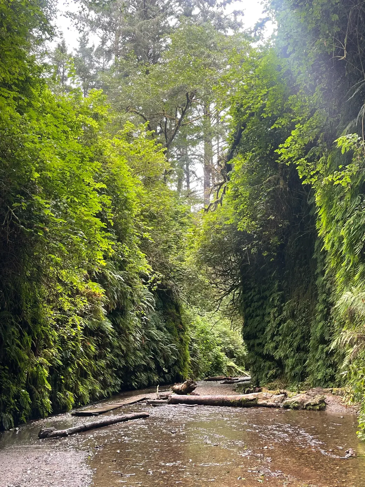
In Fern Canyon, the ferns cover the walls all the way down to the creek. · Aug 2022 · Our photo -
Gold Bluffs Beach
Stop in the day-use area for a coastal view. Give elk plenty of space and stay clear of breaking waves.
-
Tall Trees Grove
If you choose the southern groves, reserve Tall Trees and let your reservation set the start time. If you cannot get a permit, try Lady Bird Johnson Grove if Bald Hills Road and the trail are open.
Facts for Tall Trees Grove
The Tall Trees Grove sits on the alluvial floodplain of Redwood Creek, where NPS says many redwoods exceed 350 feet. The hike is a 4.5-mile round trip with 1,600 feet of total elevation change: the trail descends 800 feet to the creek, so the climbing comes on the way back. NPS calls it moderately strenuous, gives 3 to 6 hours, and says the trail has switchbacks and grades over 10 percent. The grove’s Libby Tree held the world height title until its top died back in 1994; NPS notes that the tallest tree in the world is not in this grove. 1
- Distance
- 4.5 miles round trip (NPS; the record’s metric figure, 6.5 km, does not match). 1
- Elevation
- 1,600 feet total elevation change; the trail descends 800 feet to Redwood Creek. 1
- Time
- 3-6 hours (NPS activity duration). 1
- Difficulty
- Moderately strenuous (NPS; one of the more strenuous hikes in the parks). 1
- Trailhead
- Tall Trees Trailhead; gated dirt access road. Free online reservation provides directions. 1
Stay near Orick for Prairie Creek and the southern groves, or Klamath if you plan to split your time between the north and south. Source
Good to know
For your days in Redwood
Wildlife and where to look (4)
- Roosevelt elk. Prairie Creek, Gold Bluffs Beach, Bald Hills Road, and the Orick area; calves are born in May and June; rut occurs in fall.. Keep your distance; elk are especially defensive during calving and rut. nps.gov
- Gray whale. Klamath River Overlook and other coastal overlooks; year-round at Klamath River Overlook; migration peaks vary between NPS pages.. Visit on a clear, calm day; use binoculars to look for spouts. nps.gov
- Harbor seal. Redwood Creek estuary, beaches, and offshore rocks; year-round; pups are born in April and May.. A lone pup may be waiting while its mother feeds at sea. nps.gov
- Coho salmon. Prairie Creek, viewed from bridges on the Karl Knapp Trail; autumn spawning season. Look down from trail bridges to see spawning fish. nps.gov
Night sky and light (2)
- Crescent Beach Overlook (Enderts Beach Road, south of Crescent City). Short paved trail from parking to overlook platform; two vehicle spaces. NPS names this as a sunset photography spot; fog can obscure views. nps.gov
- Lyons Ranch Trailhead (Bald Hills Road, 17 miles east of Highway 101). Gravel parking for about twelve cars; no water or facilities. NPS highlights night-sky views here. Snow can affect winter access. nps.gov
Longer drives between areas (5)
- Crescent City via Howland Hill Road to Highway 199 near Hiouchi: 10 miles, approximately 45 minutes. One way; mostly unpaved. RVs and trailers do not fit. nps.gov
- Highway 101 at Requa Road to Klamath River Overlook: 2.25 miles, about 15 minutes. One way; steep and narrow. RVs and trailers are not recommended. nps.gov
- Newton B. Drury Scenic Parkway south end to Newton B. Drury Scenic Parkway north end: 10 miles, 20-30 minutes. One way; paved. Check vehicle closures for hike-and-bike events. nps.gov
- Highway 101 at Davison Road to Fern Canyon Trailhead: 7 miles, about 30 minutes. One way; mostly unpaved with stream crossings. Trailers are prohibited. nps.gov
- Highway 101 at Bald Hills Road to Lyons Ranch Trailhead: 17 miles, about 45 minutes. One way; narrow and rough, with an unpaved final section. RVs and trailers are not advised. nps.gov
Signal, wifi and charging (3)
- Park interior and nearby towns: . nps.gov
- Developed campgrounds and backcountry: Reception listed at Jedediah Smith and Gold Bluffs Beach; none at Mill Creek, Elk Prairie, or in the backcountry. nps.gov
- Bald Hills: Lyons Ranch Trailhead: Very limited coverage; do not rely on it in an emergency. nps.gov
As the NPS lists it; coverage changes, so don’t count on a signal on the trail.
Add a guided tour to your Redwood days
Affiliate link: we may earn a commission, at no extra cost to you. How this works
Before you go
- Redwood permits and reservations: lotteries, campground and lodging booking windows.
- Best time to visit Redwood: crowds, weather and seasonal access by month.
- Plan Redwood in the trip planner: your dates, booking deadlines and a conditions check before you leave.
- Is Redwood open today? Live NPS alerts and closures.
Plans checked against official NPS pages Nov 10, 2026.