
OlympicItinerary
Olympic itinerary
1, 2, 3 or 5 Days, each day in order. Our pick: 3 days. Suggested 3-day route: day 1: Hurricane Ridge, Hurricane Hill, Marymere Falls; day 2: Rialto Beach, Hall of Mosses, Spruce Nature Trail; day 3: Ruby Beach, Beach 4, Kalaloch.
By David & Keri New, who have visited 63 of the 64 U.S. national parks
Olympic · Photo: David & Keri New
Choose your days
For one day, choose the Hoh Rain Forest. With more days, group the ridge, rain forest and coast into separate outings. Check the Hoh access road before committing to the drive.
David and Keri’s favorite: Hall of Mosses.
Times are suggested local starts. Closure flags update from the NPS alert feed when available. Check conditions again before your visit. Check park alerts
Open the free one-page planner
1 day
Make time for Hall of Mosses
Add your dates and save a copy.
Day 1 · A morning in the Hoh Rain Forest
Check Upper Hoh Road access before leaving. The times are suggested starts once you reach the trailhead. Access source
-
Hall of Mosses
0.8 mile loop trail beginning near the Visitor Center
Facts for Hall of Mosses
Begin from the Hoh information-board area, cross Taft Creek, and follow the Hall of Mosses loop. The short maple-viewing spur is separate from the main circuit. 1
- Distance
- Narrative: 0.8-mile loop; inventory: 0.86-mile loop, 1.04 miles including approach 1
- Elevation
- No total cumulative elevation gain established in the NPS listing 1
- Time
- The NPS does not publish a walking time for this route. 1
- Difficulty
- Those seeking the least-strenuous version of this hike may wish to go back along the same route at this point, as the east side of loop is more rugged than the portion already traveled. 1
- Accessibility
- Full Accessibility Description: 1
-
Spruce Nature Trail
1.2 mile loop trail beginning near the Visitor Center
Stay near Kalaloch Lodge for the west-side portion; reserve accommodation. Source
2 days
Make time for Hall of Mosses
Add your dates and save a copy.
Day 1 · Hurricane Ridge → Marymere Falls
Summer suits this combined mountain-and-coast route; July and August have mild to warm weather, while snow can persist at elevation into June. Access source
-
Hurricane Ridge
Hurricane Ridge is located 17 miles south of Port Angeles, at the end of Hurricane Ridge Road.
Facts for Hurricane Ridge
See Olympic Mountain views and subalpine meadows. 1
- Where
- Northern mountains 1
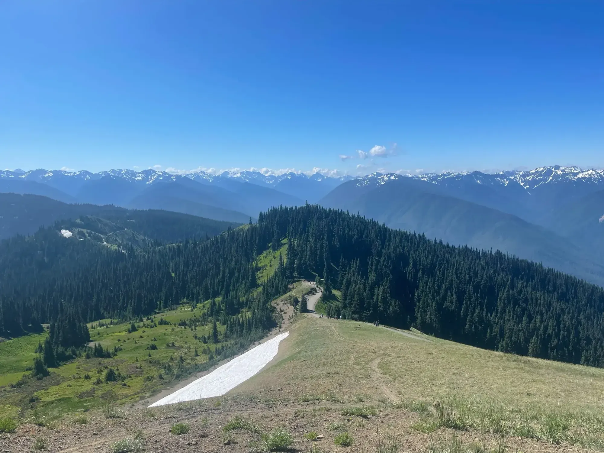
There was still a patch of snow below Hurricane Ridge on our July trip. · Jul 2021 · Our photo -
Marymere Falls
0.9 miles one way from Storm King Ranger Station.
Facts for Marymere Falls
Begin at Storm King Ranger Station for the Marymere Falls approach through old-growth forest. The Lake Crescent Lodge approach is an alternate start and is not assumed to have the same distance. 1
- Distance
- 0.9 mile one way 1
- Elevation
- No total route gain stated; the waterfall height is 90 feet 1
- Time
- The NPS does not publish a walking time for this route. 1
- Difficulty
- See the official route and surface descriptions; no separate rating added. 1
- Route
- out-and-back 2
- Trailhead
- Storm King Ranger Station at Lake Crescent 2
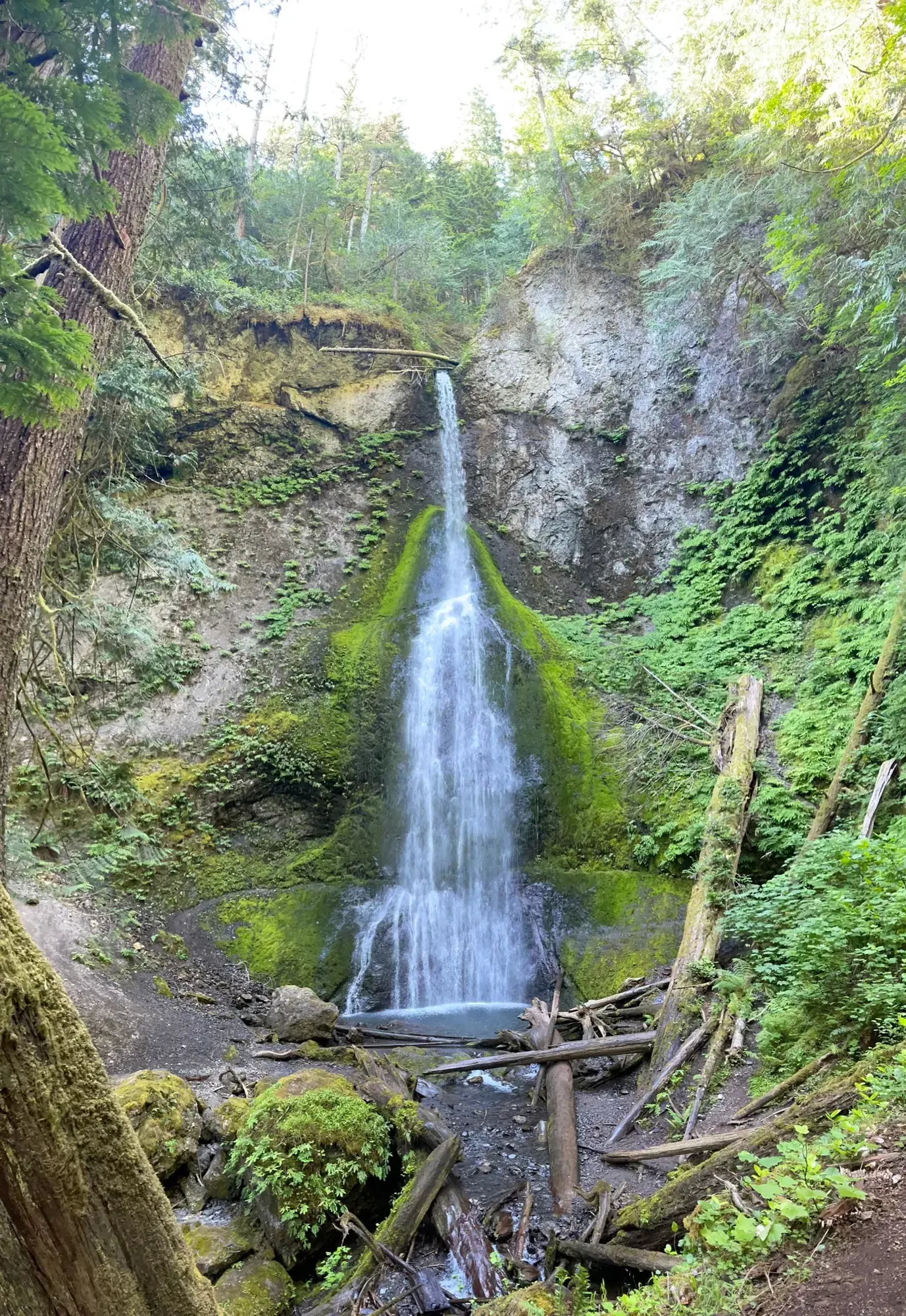
Marymere Falls dropping through a notch in the forest near Lake Crescent. · Jul 2021 · Our photo
Stay near Port Angeles for northern stops; relocate toward the west side for Hoh/coastal days. Source
Day 2 · Rialto Beach → Hall of Mosses → Spruce Nature Trail
Summer suits this combined mountain-and-coast route; July and August have mild to warm weather, while snow can persist at elevation into June. Access source
-
Rialto Beach
Rialto Beach is accessible by Mora Road, off of La Push Road.
Facts for Rialto Beach
See a pebble beach, offshore rocks, and the Pacific Ocean. 1
-
Hall of Mosses
0.8 mile loop trail beginning near the Visitor Center
Facts for Hall of Mosses
Begin from the Hoh information-board area, cross Taft Creek, and follow the Hall of Mosses loop. The short maple-viewing spur is separate from the main circuit. 1
- Distance
- Narrative: 0.8-mile loop; inventory: 0.86-mile loop, 1.04 miles including approach 1
- Elevation
- No total cumulative elevation gain established in the NPS listing 1
- Time
- The NPS does not publish a walking time for this route. 1
- Difficulty
- Those seeking the least-strenuous version of this hike may wish to go back along the same route at this point, as the east side of loop is more rugged than the portion already traveled. 1
- Accessibility
- Full Accessibility Description: 1
-
Spruce Nature Trail
1.2 mile loop trail beginning near the Visitor Center
Stay near Kalaloch Lodge for the west-side portion; reserve accommodation. Source
3 days
Make time for Hall of Mosses
Add your dates and save a copy.
Day 1 · Hurricane Ridge → Hurricane Hill → Marymere Falls
Summer suits this combined mountain-and-coast route; July and August have mild to warm weather, while snow can persist at elevation into June. Access source
-
Hurricane Ridge
Hurricane Ridge is located 17 miles south of Port Angeles, at the end of Hurricane Ridge Road.
-
Hurricane Hill
The rough paved trail gains about 700 ft. in elevation, giving panoramic views.
Facts for Hurricane Hill
Follow the paved Hurricane Hill route to its high viewpoint when conditions permit. The lower section is a legitimate shorter destination, and the accessibility description identifies 2,700 feet as a place to consider turning back. 1
- Distance
- About 3 miles round trip; accessibility inventory: 1.63 miles of trail 1
- Elevation
- Narrative: 700 feet of climb; accessibility inventory: 645 feet for entire trail 1
- Time
- The NPS does not publish a walking time for this route. 1
- Difficulty
- It is a strenuous hike past this point. 1
- Route
- out-and-back 1
- Trailhead
- Hurricane Hill Trailhead, at the end of Hurricane Hill Road 1
- Accessibility
- Full Accessibility Description 1
-
Marymere Falls
0.9 miles one way from Storm King Ranger Station.
Facts for Marymere Falls
Begin at Storm King Ranger Station for the Marymere Falls approach through old-growth forest. The Lake Crescent Lodge approach is an alternate start and is not assumed to have the same distance. 1
- Distance
- 0.9 mile one way 1
- Elevation
- No total route gain stated; the waterfall height is 90 feet 1
- Time
- The NPS does not publish a walking time for this route. 1
- Difficulty
- See the official route and surface descriptions; no separate rating added. 1
- Route
- out-and-back 2
- Trailhead
- Storm King Ranger Station at Lake Crescent 2
Stay near Port Angeles for northern stops; relocate toward the west side for Hoh/coastal days. Source
Day 2 · Rialto Beach → Hall of Mosses → Spruce Nature Trail
Summer suits this combined mountain-and-coast route; July and August have mild to warm weather, while snow can persist at elevation into June. Access source
-
Rialto Beach
Rialto Beach is accessible by Mora Road, off of La Push Road.
Facts for Rialto Beach
See a pebble beach, offshore rocks, and the Pacific Ocean. 1
-
Hall of Mosses
0.8 mile loop trail beginning near the Visitor Center
Facts for Hall of Mosses
Begin from the Hoh information-board area, cross Taft Creek, and follow the Hall of Mosses loop. The short maple-viewing spur is separate from the main circuit. 1
- Distance
- Narrative: 0.8-mile loop; inventory: 0.86-mile loop, 1.04 miles including approach 1
- Elevation
- No total cumulative elevation gain established in the NPS listing 1
- Time
- The NPS does not publish a walking time for this route. 1
- Difficulty
- Those seeking the least-strenuous version of this hike may wish to go back along the same route at this point, as the east side of loop is more rugged than the portion already traveled. 1
- Accessibility
- Full Accessibility Description: 1
-
Spruce Nature Trail
1.2 mile loop trail beginning near the Visitor Center
Stay near Kalaloch Lodge for the west-side portion; reserve accommodation. Source
Day 3 · Ruby Beach → Beach 4 → Kalaloch
Summer suits this combined mountain-and-coast route; July and August have mild to warm weather, while snow can persist at elevation into June. Access source
-
Beach 4
0.2 mile one way walk from Highway 101 to a beach and tidepools
-
Kalaloch
Kalaloch Lodge , located right on the beach, has rooms and cabins available upon reservation.
Facts for Kalaloch
Kalaloch Campground is on the reservation system May 15, 2026 - September 20, 2026. Important changes to the reservation booking windows : To better serve visitors, Kalaloch Campground will be releasing campsites in a series of three staggered block releases by loop. 1
Stay near Kalaloch Lodge for the west-side portion; reserve accommodation. Source
5 days
Make time for Hall of Mosses
Add your dates and save a copy.
Day 1 · Hurricane Ridge → Hurricane Hill
Summer suits this combined mountain-and-coast route; July and August have mild to warm weather, while snow can persist at elevation into June. Access source
-
Hurricane Ridge
Hurricane Ridge is located 17 miles south of Port Angeles, at the end of Hurricane Ridge Road.
-
Hurricane Hill
The rough paved trail gains about 700 ft. in elevation, giving panoramic views.
Facts for Hurricane Hill
Follow the paved Hurricane Hill route to its high viewpoint when conditions permit. The lower section is a legitimate shorter destination, and the accessibility description identifies 2,700 feet as a place to consider turning back. 1
- Distance
- About 3 miles round trip; accessibility inventory: 1.63 miles of trail 1
- Elevation
- Narrative: 700 feet of climb; accessibility inventory: 645 feet for entire trail 1
- Time
- The NPS does not publish a walking time for this route. 1
- Difficulty
- It is a strenuous hike past this point. 1
- Route
- out-and-back 1
- Trailhead
- Hurricane Hill Trailhead, at the end of Hurricane Hill Road 1
- Accessibility
- Full Accessibility Description 1
Stay near Port Angeles for northern stops; relocate toward the west side for Hoh/coastal days. Source
Day 2 · Marymere Falls → Sol Duc Falls
Summer suits this combined mountain-and-coast route; July and August have mild to warm weather, while snow can persist at elevation into June. Access source
-
Marymere Falls
0.9 miles one way from Storm King Ranger Station.
Facts for Marymere Falls
Begin at Storm King Ranger Station for the Marymere Falls approach through old-growth forest. The Lake Crescent Lodge approach is an alternate start and is not assumed to have the same distance. 1
- Distance
- 0.9 mile one way 1
- Elevation
- No total route gain stated; the waterfall height is 90 feet 1
- Time
- The NPS does not publish a walking time for this route. 1
- Difficulty
- See the official route and surface descriptions; no separate rating added. 1
- Route
- out-and-back 2
- Trailhead
- Storm King Ranger Station at Lake Crescent 2
-
Sol Duc Falls
0.8 miles one way from the end of the Sol Duc Road.
Facts for Sol Duc Falls
Use the short end-of-road approach through old-growth forest to the designated Sol Duc Falls viewing areas, then return. Longer Sol Duc valley routes are separate trips. 1
- Distance
- 0.8 mile one way from the end-of-road parking area 1
- Elevation
- Described as relatively level; no numerical total gain in this NPS listing 1
- Time
- The NPS does not publish a walking time for this route. 1
- Difficulty
- Perhaps the most picturesque waterfall in Olympic, Sol Duc Falls is a treat - a big reward for a fairly easy hike. 1
- Route
- out-and-back 2
- Trailhead
- End of Sol Duc Road 2
- Where
- Sol Duc Valley 2
- Walking
- 0.8 mi each way 2
- Access features
- Wheelchair Accessible 1
Stay near Port Angeles for northern stops; relocate toward the west side for Hoh/coastal days. Source
Day 3 · Rialto Beach → Hall of Mosses → Spruce Nature Trail
Summer suits this combined mountain-and-coast route; July and August have mild to warm weather, while snow can persist at elevation into June. Access source
-
Rialto Beach
Rialto Beach is accessible by Mora Road, off of La Push Road.
Facts for Rialto Beach
See a pebble beach, offshore rocks, and the Pacific Ocean. 1
-
Hall of Mosses
0.8 mile loop trail beginning near the Visitor Center
Facts for Hall of Mosses
Begin from the Hoh information-board area, cross Taft Creek, and follow the Hall of Mosses loop. The short maple-viewing spur is separate from the main circuit. 1
- Distance
- Narrative: 0.8-mile loop; inventory: 0.86-mile loop, 1.04 miles including approach 1
- Elevation
- No total cumulative elevation gain established in the NPS listing 1
- Time
- The NPS does not publish a walking time for this route. 1
- Difficulty
- Those seeking the least-strenuous version of this hike may wish to go back along the same route at this point, as the east side of loop is more rugged than the portion already traveled. 1
- Accessibility
- Full Accessibility Description: 1
-
Spruce Nature Trail
1.2 mile loop trail beginning near the Visitor Center
Stay near Kalaloch Lodge for the west-side portion; reserve accommodation. Source
Day 4 · Ruby Beach → Beach 4 → Kalaloch
Summer suits this combined mountain-and-coast route; July and August have mild to warm weather, while snow can persist at elevation into June. Access source
-
Beach 4
0.2 mile one way walk from Highway 101 to a beach and tidepools
-
Kalaloch
Kalaloch Lodge , located right on the beach, has rooms and cabins available upon reservation.
Facts for Kalaloch
Kalaloch Campground is on the reservation system May 15, 2026 - September 20, 2026. Important changes to the reservation booking windows : To better serve visitors, Kalaloch Campground will be releasing campsites in a series of three staggered block releases by loop. 1
Stay near Kalaloch Lodge for the west-side portion; reserve accommodation. Source
Day 5 · Maple Glade Trail → Kestner Homestead Trail
Summer suits this combined mountain-and-coast route; July and August have mild to warm weather, while snow can persist at elevation into June. Access source
-
Maple Glade Trail
0.5 mile loop beginning at the Quinault River Ranger Station on the north shore of Lake Quinault.
Facts for Maple Glade Trail
-
Kestner Homestead Trail
1.3 mile loop trail starting at the Quinault River Ranger Station on the north shore of Lake Quinault
Stay near Kalaloch Lodge for the west-side portion; reserve accommodation. Source
Good to know
For your days in Olympic
Wildlife and where to look (5)
- Roosevelt elk. Lower valleys and rain forests; most often dawn or dusk. Stay at least 150 feet away; use extra caution during calving and the rut. nps.gov
- Olympic marmot. Hurricane Ridge and other alpine trails; summer, annually. Watch from a distance and never feed marmots. nps.gov
- Black-tailed deer. Forests and mountain areas throughout the park; morning and evening. Stay at least 150 feet away; watch for deer crossing roads. nps.gov
- Pacific salmon. Salmon Cascades Overlook, Sol Duc Valley; late September–early October, annual fall migration. See migrating fish from the overlook. nps.gov
- Gray whales. Kalaloch, Rialto, and Shi Shi beaches; annual migrations: April–May and October–November. Check tides before walking the coast. nps.gov
Night sky and light (1)
- Rialto Beach (Mora coast). Short path from parking to the beach NPS identifies the beach in a sunset photograph. nps.gov
Longer drives between areas (8)
- Olympic National Park Visitor Center/WIC, Port Angeles to Hurricane Ridge Ranger Station: 17 miles, 45 minutes. Published planning estimate; weather, traffic, and road work can add time. nps.gov
- Olympic National Park Visitor Center/WIC, Port Angeles to Elwha Ranger Station: 11 miles, 30 minutes. Published planning estimate; weather, traffic, and road work can add time. nps.gov
- Olympic National Park Visitor Center/WIC, Port Angeles to Lake Crescent/Storm King Ranger Station: 21 miles, 30 minutes. Published planning estimate; weather, traffic, and road work can add time. nps.gov
- Olympic National Park Visitor Center/WIC, Port Angeles to Sol Duc/Eagle Ranger Station: 40 miles, 1 hour 15 minutes. Published planning estimate; weather, traffic, and road work can add time. nps.gov
- Olympic National Park Visitor Center/WIC, Port Angeles to Mora Ranger Station: 70 miles, 1 hour 30 minutes. Published planning estimate; weather, traffic, and road work can add time. nps.gov
- Olympic National Park Visitor Center/WIC, Port Angeles to Ozette Ranger Station: 76 miles, 2 hours. Published planning estimate; weather, traffic, and road work can add time. nps.gov
- Olympic National Park Visitor Center/WIC, Port Angeles to Hoh Rain Forest Visitor Center: 91 miles, 2 hours 15 minutes. Published planning estimate; weather, traffic, and road work can add time. nps.gov
- Olympic National Park Visitor Center/WIC, Port Angeles to Kalaloch Ranger Station: 95 miles, 2 hours 15 minutes. Published planning estimate; weather, traffic, and road work can add time. nps.gov
Signal, wifi and charging (3)
- Hoh Rain Forest Visitor Center: . nps.gov
- Hurricane Ridge: . nps.gov
- Kalaloch Lodge: . thekalalochlodge.com
As the NPS lists it; coverage changes, so don’t count on a signal on the trail.
Add a guided tour to your Olympic days
Affiliate link: we may earn a commission, at no extra cost to you. How this works
Affiliate link: we may earn a commission, at no extra cost to you. How this works
Before you go
- Olympic permits and reservations: lotteries, campground and lodging booking windows.
- Best time to visit Olympic: crowds, weather and seasonal access by month.
- Plan Olympic in the trip planner: your dates, booking deadlines and a conditions check before you leave.
- Is Olympic open today? Live NPS alerts and closures.
Plans checked against official NPS pages Nov 20, 2026.