
Lassen VolcanicItinerary
Lassen Volcanic itinerary
Free 1-, 2-, 3-, and 5-day plans for Lassen Volcanic, from steaming boardwalks to alpine lakes and two volcanic climbs.
By David & Keri New, who have visited 63 of the 64 U.S. national parks
Lassen Volcanic · Photo: David & Keri New
Choose your days
Plan your days around the road first. Start with Bumpass Hell if it is open, then add Lassen Peak and Manzanita Lake. Give Butte Lake and Warner Valley separate days and check their access roads before setting out.
Snow can close Lassen National Park Highway (Hwy 89) to through traffic. Check how far you can drive from each entrance and whether the trail is open before choosing your day. NPS road and trail conditions Closed: NPS alert ↗
David and Keri’s favorite: Bumpass Hell Trail.
Times are suggested local starts. Closure flags update from the NPS alert feed when available. Check conditions again before your visit. Check park alerts
Open the free one-page planner
1 day
Make time for Bumpass Hell Trail
Add your dates and save a copy.
Day 1 · Bumpass Hell and Sulphur Works
Check the highway from the southwest entrance and the Bumpass Hell Trail itself. The trail stays closed while unsafe snow lingers. If it is closed, use the Sulphur Works sidewalk only if the road and viewing area are open. If access ends at the visitor center, check its hours or use the northwest entrance for the Manzanita Lake Loop if the path is safe. Access source
3 stops in order. Positions from OpenStreetMap, NPS visitor center listing; map data loads from OpenStreetMap when you tap. Not for navigation.
-
Bumpass Hell Trail
Hike to the hydrothermal basin if the trail is open. Start early for the small parking lot and stay on the marked trail and boardwalk.
Our tip Check the road and trail status before you build a trip around them. Snow can keep the park highway and high trails like Bumpass Hell closed into June or even July. David & Keri
Facts for Bumpass Hell Trail
Walk from the Bumpass Hell parking area to the basin overlook and designated hydrothermal boardwalks, then return. Stay on the established trail and boardwalk system throughout the basin. 1
- Distance
- 3 miles round trip 1
- Elevation
- Narrative: 200-foot basin descent; accessibility text: 300-foot descent 1
- Time
- 90 Minutes 1
- Difficulty
- The Bumpass Hell Trail is one of the most popular trails in the park. From the trailhead, the first mile is mostly flat and traverses the northeast slope of Bumpass Mountain with views of Little Hot Springs Valley and numerous volcanic peaks. An overlook at about 0.5 mile provides a panoramic view of the five remnant peaks of the ancestral Brokeoff Volcano. At about one mile, an overlook provides a view into the Bumpass Hell basin. From here, the trail drops 300 feet into the basin where a boardwalk provides an up-close view of the hydrothermal features. A second trail skirts the northern edge of the basin and continues up the eastern edge of the basin to a second overlook, which provides an additional view of the basin. Most hikers stop here and return the way they came to the Bumpass Hell Trailhead. 1
- Route
- out-and-back 1
- Trailhead
- Bumpass Hell parking area on the park highway. 1
- Where
- Southwest 1
- Walking
- 3 mi round trip 1
- Season
- Summer–fall access varies with snow; 2026 trail opened June 26. 1
-
Sulphur Works
Stop on the drive back toward the southwest entrance. See the steaming ground from the designated sidewalk if it is open.
Facts for Sulphur Works
See steaming ground and bubbling mudpots beside the park highway. 1
- Where
- Southwest 1
- Walking
- Short paved sidewalk 1
- Season
- Year-round; winter access requires travel over snow. 1
- Time
- 10 Minutes 1
- Dogs
- Allowed with restrictions 1
- Accessibility
- The sidewalk to Sulphur Works is paved and accessible to wheelchairs. There is a slight incline between the parking area and viewpoint. Two vault toilets in the parking area are wheelchair accessible. 1
- Access features
- Restroom - Accessible 2
-
Kohm Yah-mah-nee Visitor CenterPartly closed: NPS alert ↗
If open, check in here for the next day’s road and trail conditions.
Facts for Kohm Yah-mah-nee Visitor Center
This year-round visitor center is located one mile from the Southwest Entrance. The visitor center offers an information desk, exhibit hall, auditorium, amphitheater (summer), park store, dining area, patio (summer), and a gift shop and cafe (summer). Free Wi-Fi is available inside. 0
Stay near Mineral for the southwest entrance. Source
2 days
Make time for Lassen Peak Trail
Add your dates and save a copy.
Day 1 · Bumpass Hell and Sulphur Works
Check the highway from the southwest entrance and the Bumpass Hell Trail itself. The trail stays closed while unsafe snow lingers. If it is closed, use the Sulphur Works sidewalk only if the road and viewing area are open. If access ends at the visitor center, check its hours or use the northwest entrance for the Manzanita Lake Loop if the path is safe. Access source
3 stops in order. Positions from OpenStreetMap, NPS visitor center listing; map data loads from OpenStreetMap when you tap. Not for navigation.
-
Bumpass Hell Trail
Hike to the hydrothermal basin if the trail is open. Start early for the small parking lot and stay on the marked trail and boardwalk.
Our tip Check the road and trail status before you build a trip around them. Snow can keep the park highway and high trails like Bumpass Hell closed into June or even July. David & Keri
Facts for Bumpass Hell Trail
Walk from the Bumpass Hell parking area to the basin overlook and designated hydrothermal boardwalks, then return. Stay on the established trail and boardwalk system throughout the basin. 1
- Distance
- 3 miles round trip 1
- Elevation
- Narrative: 200-foot basin descent; accessibility text: 300-foot descent 1
- Time
- 90 Minutes 1
- Difficulty
- The Bumpass Hell Trail is one of the most popular trails in the park. From the trailhead, the first mile is mostly flat and traverses the northeast slope of Bumpass Mountain with views of Little Hot Springs Valley and numerous volcanic peaks. An overlook at about 0.5 mile provides a panoramic view of the five remnant peaks of the ancestral Brokeoff Volcano. At about one mile, an overlook provides a view into the Bumpass Hell basin. From here, the trail drops 300 feet into the basin where a boardwalk provides an up-close view of the hydrothermal features. A second trail skirts the northern edge of the basin and continues up the eastern edge of the basin to a second overlook, which provides an additional view of the basin. Most hikers stop here and return the way they came to the Bumpass Hell Trailhead. 1
- Route
- out-and-back 1
- Trailhead
- Bumpass Hell parking area on the park highway. 1
- Where
- Southwest 1
- Walking
- 3 mi round trip 1
- Season
- Summer–fall access varies with snow; 2026 trail opened June 26. 1
-
Sulphur Works
Stop on the drive back toward the southwest entrance. See the steaming ground from the designated sidewalk if it is open.
Facts for Sulphur Works
See steaming ground and bubbling mudpots beside the park highway. 1
- Where
- Southwest 1
- Walking
- Short paved sidewalk 1
- Season
- Year-round; winter access requires travel over snow. 1
- Time
- 10 Minutes 1
- Dogs
- Allowed with restrictions 1
- Accessibility
- The sidewalk to Sulphur Works is paved and accessible to wheelchairs. There is a slight incline between the parking area and viewpoint. Two vault toilets in the parking area are wheelchair accessible. 1
- Access features
- Restroom - Accessible 2
-
Kohm Yah-mah-nee Visitor CenterPartly closed: NPS alert ↗
If open, check in here for the next day’s road and trail conditions.
Facts for Kohm Yah-mah-nee Visitor Center
This year-round visitor center is located one mile from the Southwest Entrance. The visitor center offers an information desk, exhibit hall, auditorium, amphitheater (summer), park store, dining area, patio (summer), and a gift shop and cafe (summer). Free Wi-Fi is available inside. 0
Stay near Mineral for the southwest entrance. Source
Day 2 · Lassen Peak and Lake Helen
Confirm that vehicles can reach the Lassen Peak trailhead and that the trail is clear. Skip the summit in snow, ice, thunderstorms, or high winds. If the road reaches Lake Helen and its picnic area is open, make that the main stop. Otherwise use an open stop near the entrance or swap in the Manzanita Lake day. Access source
-
Lassen Peak Trail
Give this strenuous summit hike the morning. Carry water and layers, stay on the switchbacks, and turn around if weather or trail conditions deteriorate.
Facts for Lassen Peak Trail
Follow the maintained trail through its switchbacks to the first summit, where NPS says the maintained trail ends. Treat any further travel toward the true summit or crater interior as a separate decision. 1
- Distance
- 5 miles round trip 1
- Elevation
- 1,957 feet of gain from a starting elevation of 8,500 feet 1
- Time
- 4-5 Hours 1
- Difficulty
- Hiking 1
- Route
- out-and-back 1
- Trailhead
- Lassen Peak parking area on the park highway. 1
- Where
- Park highway high point 1
- Walking
- 5 mi round trip 1
- Season
- Summer, Fall 1
- Dogs
- Not allowed 1
- Accessibility
- Not accessible to wheelchairs. 1
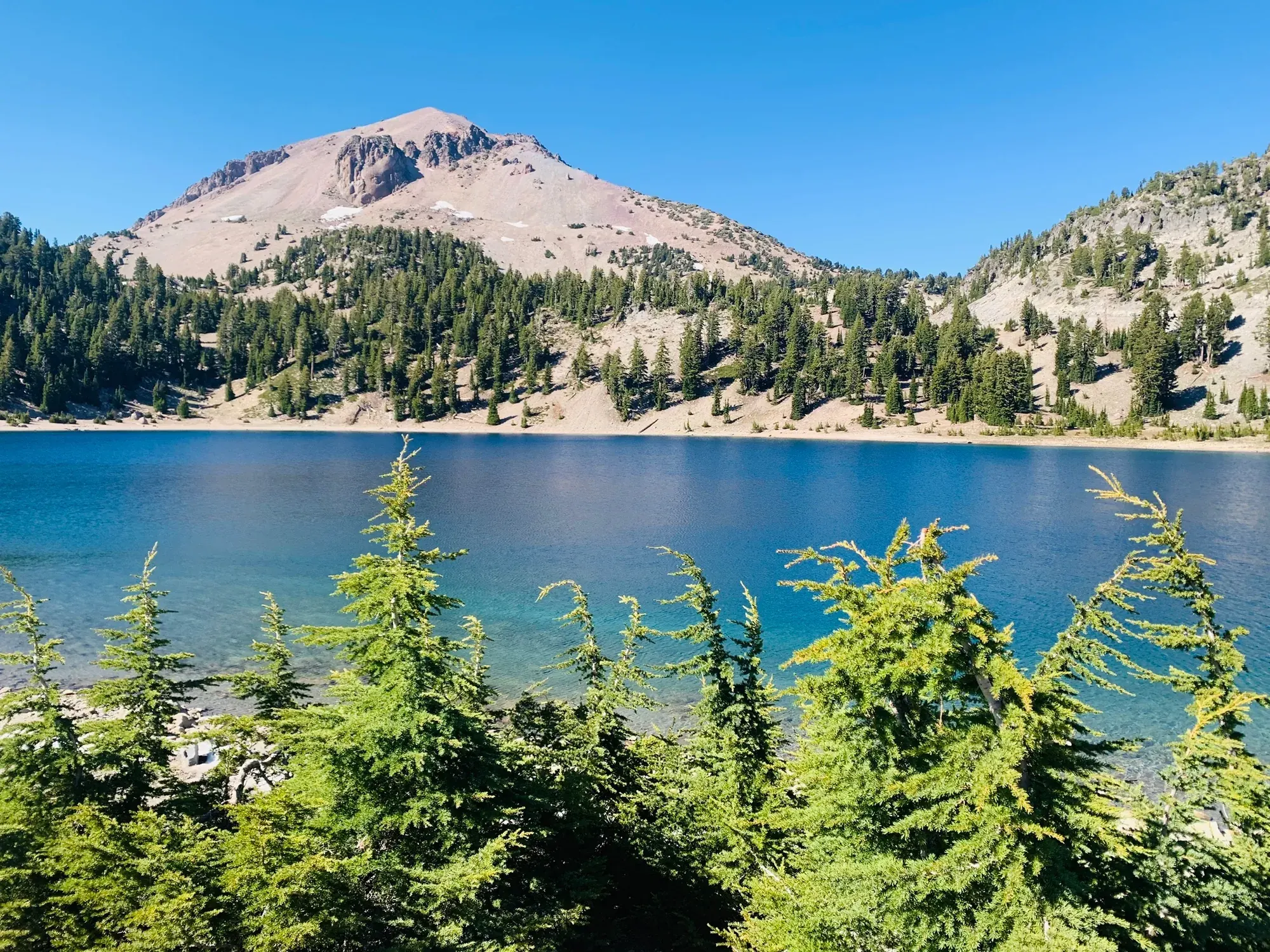
Lassen Peak above the blue water of Lake Helen. · Jul 2020 · Our photo -
Lake Helen Picnic Area
Leave time for lunch by the lake after the climb. Use the signed picnic area if open.
Facts for Lake Helen Picnic Area
See an alpine lake beneath Lassen Peak, with reflections on calm days. 1
Stay near Mineral for the southwest entrance. Source
3 days
Make time for Lassen Peak Trail
Add your dates and save a copy.
Day 1 · Bumpass Hell and Sulphur Works
Check the highway from the southwest entrance and the Bumpass Hell Trail itself. The trail stays closed while unsafe snow lingers. If it is closed, use the Sulphur Works sidewalk only if the road and viewing area are open. If access ends at the visitor center, check its hours or use the northwest entrance for the Manzanita Lake Loop if the path is safe. Access source
3 stops in order. Positions from OpenStreetMap, NPS visitor center listing; map data loads from OpenStreetMap when you tap. Not for navigation.
-
Bumpass Hell Trail
Hike to the hydrothermal basin if the trail is open. Start early for the small parking lot and stay on the marked trail and boardwalk.
Our tip Check the road and trail status before you build a trip around them. Snow can keep the park highway and high trails like Bumpass Hell closed into June or even July. David & Keri
Facts for Bumpass Hell Trail
Walk from the Bumpass Hell parking area to the basin overlook and designated hydrothermal boardwalks, then return. Stay on the established trail and boardwalk system throughout the basin. 1
- Distance
- 3 miles round trip 1
- Elevation
- Narrative: 200-foot basin descent; accessibility text: 300-foot descent 1
- Time
- 90 Minutes 1
- Difficulty
- The Bumpass Hell Trail is one of the most popular trails in the park. From the trailhead, the first mile is mostly flat and traverses the northeast slope of Bumpass Mountain with views of Little Hot Springs Valley and numerous volcanic peaks. An overlook at about 0.5 mile provides a panoramic view of the five remnant peaks of the ancestral Brokeoff Volcano. At about one mile, an overlook provides a view into the Bumpass Hell basin. From here, the trail drops 300 feet into the basin where a boardwalk provides an up-close view of the hydrothermal features. A second trail skirts the northern edge of the basin and continues up the eastern edge of the basin to a second overlook, which provides an additional view of the basin. Most hikers stop here and return the way they came to the Bumpass Hell Trailhead. 1
- Route
- out-and-back 1
- Trailhead
- Bumpass Hell parking area on the park highway. 1
- Where
- Southwest 1
- Walking
- 3 mi round trip 1
- Season
- Summer–fall access varies with snow; 2026 trail opened June 26. 1
-
Sulphur Works
Stop on the drive back toward the southwest entrance. See the steaming ground from the designated sidewalk if it is open.
Facts for Sulphur Works
See steaming ground and bubbling mudpots beside the park highway. 1
- Where
- Southwest 1
- Walking
- Short paved sidewalk 1
- Season
- Year-round; winter access requires travel over snow. 1
- Time
- 10 Minutes 1
- Dogs
- Allowed with restrictions 1
- Accessibility
- The sidewalk to Sulphur Works is paved and accessible to wheelchairs. There is a slight incline between the parking area and viewpoint. Two vault toilets in the parking area are wheelchair accessible. 1
- Access features
- Restroom - Accessible 2
-
Kohm Yah-mah-nee Visitor CenterPartly closed: NPS alert ↗
If open, check in here for the next day’s road and trail conditions.
Facts for Kohm Yah-mah-nee Visitor Center
This year-round visitor center is located one mile from the Southwest Entrance. The visitor center offers an information desk, exhibit hall, auditorium, amphitheater (summer), park store, dining area, patio (summer), and a gift shop and cafe (summer). Free Wi-Fi is available inside. 0
Stay near Mineral for the southwest entrance. Source
Day 2 · Lassen Peak and Lake Helen
Confirm that vehicles can reach the Lassen Peak trailhead and that the trail is clear. Skip the summit in snow, ice, thunderstorms, or high winds. If the road reaches Lake Helen and its picnic area is open, make that the main stop. Otherwise use an open stop near the entrance or swap in the Manzanita Lake day. Access source
-
Lassen Peak Trail
Give this strenuous summit hike the morning. Carry water and layers, stay on the switchbacks, and turn around if weather or trail conditions deteriorate.
Facts for Lassen Peak Trail
Follow the maintained trail through its switchbacks to the first summit, where NPS says the maintained trail ends. Treat any further travel toward the true summit or crater interior as a separate decision. 1
- Distance
- 5 miles round trip 1
- Elevation
- 1,957 feet of gain from a starting elevation of 8,500 feet 1
- Time
- 4-5 Hours 1
- Difficulty
- Hiking 1
- Route
- out-and-back 1
- Trailhead
- Lassen Peak parking area on the park highway. 1
- Where
- Park highway high point 1
- Walking
- 5 mi round trip 1
- Season
- Summer, Fall 1
- Dogs
- Not allowed 1
- Accessibility
- Not accessible to wheelchairs. 1
-
Lake Helen Picnic Area
Leave time for lunch by the lake after the climb. Use the signed picnic area if open.
Facts for Lake Helen Picnic Area
See an alpine lake beneath Lassen Peak, with reflections on calm days. 1
Stay near Mineral for the southwest entrance. Source
Day 3 · Manzanita Lake and the Devastated Area
Use the northwest entrance. If the highway is closed past Loomis Plaza or before the Devastated Area, keep the day around Manzanita Lake and Lily Pond if their paths are safe. Use the NPS detour around the park when moving between entrances during a through closure. Access source
-
Manzanita Lake Loop
Walk the lakeshore for views of Lassen Peak. Allow time for the reflection and turn back if the path is icy.
Facts for Manzanita Lake Loop
See Lassen Peak and Chaos Crags across the lake. 1
- Time
- 30–90 minutes 1
- Route
- loop 1
- Trailhead
- Loomis Plaza or Manzanita Lake Picnic Area/Boat Launch, off Manzanita Lake Campground Road. 1
- Where
- Northwest 1
- Walking
- 1.7 mi loop 1
- Season
- Year-round; snow may remain through April. 1
- Dogs
- Not allowed 1
- Accessibility
- The trail is not recommended for wheelchair use. The trail is narrow in places with numerous obstacles including tree roots and exposed rocks. Individuals in wheelchairs can access the Manzanita… 1
- Campsites
- 170 sites listed on Recreation.gov 2
- Booking
- Dates and availability on Recreation.gov 2
-
Lily Pond Interpretive Trail
Take the short interpretive loop near Loomis Plaza if the trail is clear.
Facts for Lily Pond Interpretive Trail
A half-mile, self-led, interpretive loop explores the rich diversity of plant and animal life in the Manzanita Lake Area. 1
-
Devastated Area Interpretive Trail
If the highway reaches the trailhead, read the waysides on the short loop about Lassen Peak’s eruptions and the rocks they left behind.
Facts for Devastated Area Interpretive Trail
See eruption deposits and exhibits explaining Lassen Peak’s 1915–1916 eruptions. 1
- Time
- 15 minutes 1
- Route
- loop 1
- Trailhead
- Devastated Area parking area on the park highway, 10 miles from the Northwest Entrance. 1
- Where
- Park highway 1
- Walking
- 0.2 mi wheelchair-accessible loop 1
- Season
- Summer, Fall 1
- Dogs
- Not allowed 1
- Accessibility
- The 0.2-mile loop is hardpacked, decomposed granite. Maximum trail grade is 5% with maximum 2% cross slope. Trail is 6 feet wide and 1,110 feet long. The trail is passable by wheelchair. Push… 1
- Access features
- Audio Description 2
Stay near Shingletown for the northwest entrance, or check seasonal camping at Manzanita Lake. Source
5 days
Make time for Bumpass Hell Trail
Add your dates and save a copy.
Day 1 · Bumpass Hell and Sulphur Works
Check the highway from the southwest entrance and the Bumpass Hell Trail itself. The trail stays closed while unsafe snow lingers. If it is closed, use the Sulphur Works sidewalk only if the road and viewing area are open. If access ends at the visitor center, check its hours or use the northwest entrance for the Manzanita Lake Loop if the path is safe. Access source
3 stops in order. Positions from OpenStreetMap, NPS visitor center listing; map data loads from OpenStreetMap when you tap. Not for navigation.
-
Bumpass Hell Trail
Hike to the hydrothermal basin if the trail is open. Start early for the small parking lot and stay on the marked trail and boardwalk.
Our tip Check the road and trail status before you build a trip around them. Snow can keep the park highway and high trails like Bumpass Hell closed into June or even July. David & Keri
Facts for Bumpass Hell Trail
Walk from the Bumpass Hell parking area to the basin overlook and designated hydrothermal boardwalks, then return. Stay on the established trail and boardwalk system throughout the basin. 1
- Distance
- 3 miles round trip 1
- Elevation
- Narrative: 200-foot basin descent; accessibility text: 300-foot descent 1
- Time
- 90 Minutes 1
- Difficulty
- The Bumpass Hell Trail is one of the most popular trails in the park. From the trailhead, the first mile is mostly flat and traverses the northeast slope of Bumpass Mountain with views of Little Hot Springs Valley and numerous volcanic peaks. An overlook at about 0.5 mile provides a panoramic view of the five remnant peaks of the ancestral Brokeoff Volcano. At about one mile, an overlook provides a view into the Bumpass Hell basin. From here, the trail drops 300 feet into the basin where a boardwalk provides an up-close view of the hydrothermal features. A second trail skirts the northern edge of the basin and continues up the eastern edge of the basin to a second overlook, which provides an additional view of the basin. Most hikers stop here and return the way they came to the Bumpass Hell Trailhead. 1
- Route
- out-and-back 1
- Trailhead
- Bumpass Hell parking area on the park highway. 1
- Where
- Southwest 1
- Walking
- 3 mi round trip 1
- Season
- Summer–fall access varies with snow; 2026 trail opened June 26. 1
-
Sulphur Works
Stop on the drive back toward the southwest entrance. See the steaming ground from the designated sidewalk if it is open.
Facts for Sulphur Works
See steaming ground and bubbling mudpots beside the park highway. 1
- Where
- Southwest 1
- Walking
- Short paved sidewalk 1
- Season
- Year-round; winter access requires travel over snow. 1
- Time
- 10 Minutes 1
- Dogs
- Allowed with restrictions 1
- Accessibility
- The sidewalk to Sulphur Works is paved and accessible to wheelchairs. There is a slight incline between the parking area and viewpoint. Two vault toilets in the parking area are wheelchair accessible. 1
- Access features
- Restroom - Accessible 2
-
Kohm Yah-mah-nee Visitor CenterPartly closed: NPS alert ↗
If open, check in here for the next day’s road and trail conditions.
Facts for Kohm Yah-mah-nee Visitor Center
This year-round visitor center is located one mile from the Southwest Entrance. The visitor center offers an information desk, exhibit hall, auditorium, amphitheater (summer), park store, dining area, patio (summer), and a gift shop and cafe (summer). Free Wi-Fi is available inside. 0
Stay near Mineral for the southwest entrance. Source
Day 2 · Lassen Peak and Lake Helen
Confirm that vehicles can reach the Lassen Peak trailhead and that the trail is clear. Skip the summit in snow, ice, thunderstorms, or high winds. If the road reaches Lake Helen and its picnic area is open, make that the main stop. Otherwise use an open stop near the entrance or swap in the Manzanita Lake day. Access source
-
Lassen Peak Trail
Give this strenuous summit hike the morning. Carry water and layers, stay on the switchbacks, and turn around if weather or trail conditions deteriorate.
Facts for Lassen Peak Trail
Follow the maintained trail through its switchbacks to the first summit, where NPS says the maintained trail ends. Treat any further travel toward the true summit or crater interior as a separate decision. 1
- Distance
- 5 miles round trip 1
- Elevation
- 1,957 feet of gain from a starting elevation of 8,500 feet 1
- Time
- 4-5 Hours 1
- Difficulty
- Hiking 1
- Route
- out-and-back 1
- Trailhead
- Lassen Peak parking area on the park highway. 1
- Where
- Park highway high point 1
- Walking
- 5 mi round trip 1
- Season
- Summer, Fall 1
- Dogs
- Not allowed 1
- Accessibility
- Not accessible to wheelchairs. 1
-
Lake Helen Picnic Area
Leave time for lunch by the lake after the climb. Use the signed picnic area if open.
Facts for Lake Helen Picnic Area
See an alpine lake beneath Lassen Peak, with reflections on calm days. 1
Stay near Mineral for the southwest entrance. Source
Day 3 · Manzanita Lake and the Devastated Area
Use the northwest entrance. If the highway is closed past Loomis Plaza or before the Devastated Area, keep the day around Manzanita Lake and Lily Pond if their paths are safe. Use the NPS detour around the park when moving between entrances during a through closure. Access source
-
Manzanita Lake Loop
Walk the lakeshore for views of Lassen Peak. Allow time for the reflection and turn back if the path is icy.
Facts for Manzanita Lake Loop
See Lassen Peak and Chaos Crags across the lake. 1
- Time
- 30–90 minutes 1
- Route
- loop 1
- Trailhead
- Loomis Plaza or Manzanita Lake Picnic Area/Boat Launch, off Manzanita Lake Campground Road. 1
- Where
- Northwest 1
- Walking
- 1.7 mi loop 1
- Season
- Year-round; snow may remain through April. 1
- Dogs
- Not allowed 1
- Accessibility
- The trail is not recommended for wheelchair use. The trail is narrow in places with numerous obstacles including tree roots and exposed rocks. Individuals in wheelchairs can access the Manzanita… 1
- Campsites
- 170 sites listed on Recreation.gov 2
- Booking
- Dates and availability on Recreation.gov 2
-
Lily Pond Interpretive Trail
Take the short interpretive loop near Loomis Plaza if the trail is clear.
Facts for Lily Pond Interpretive Trail
A half-mile, self-led, interpretive loop explores the rich diversity of plant and animal life in the Manzanita Lake Area. 1
-
Devastated Area Interpretive Trail
If the highway reaches the trailhead, read the waysides on the short loop about Lassen Peak’s eruptions and the rocks they left behind.
Facts for Devastated Area Interpretive Trail
See eruption deposits and exhibits explaining Lassen Peak’s 1915–1916 eruptions. 1
- Time
- 15 minutes 1
- Route
- loop 1
- Trailhead
- Devastated Area parking area on the park highway, 10 miles from the Northwest Entrance. 1
- Where
- Park highway 1
- Walking
- 0.2 mi wheelchair-accessible loop 1
- Season
- Summer, Fall 1
- Dogs
- Not allowed 1
- Accessibility
- The 0.2-mile loop is hardpacked, decomposed granite. Maximum trail grade is 5% with maximum 2% cross slope. Trail is 6 feet wide and 1,110 feet long. The trail is passable by wheelchair. Push… 1
- Access features
- Audio Description 2
Stay near Shingletown for the northwest entrance, or check seasonal camping at Manzanita Lake. Source
Day 4 · Butte Lake and Cinder Cone
Approach Butte Lake Road from Highway 44. The dirt and gravel road is separate from the park highway, can be rutted, and has no winter maintenance. If the road or trail is closed or unsuitable for your vehicle, swap in an accessible stop from the Manzanita Lake day. Access source
2 stops in order. Positions from OpenStreetMap, Recreation.gov campground; map data loads from OpenStreetMap when you tap. Not for navigation.
-
Cinder Cone Trail
Start at the Butte Lake parking area. The cone is steep and loose underfoot. The base of the cone offers a view of the Painted Dunes if you skip the climb.
-
Butte Lake Day Use Area
Have lunch by the lake and take in the lava rock along the shore before heading back to Highway 44.
Stay near Shingletown for the northwest entrance, or check seasonal camping at Manzanita Lake. Source
Day 5 · Warner Valley and Boiling Springs Lake
Approach from Chester and check Warner Valley Road separately. Its steep dirt section is not recommended for trailers. Check trail conditions and burn hazards before leaving. If the access road or trail is closed, use an open southwest entrance stop instead. Access source
-
Warner Valley Day Use Area
Use the trailhead parking for Boiling Springs Lake if access is open. Read posted notices before setting out.
-
Boiling Springs Lake Trail
Take the signed trail to the hydrothermal lake and stay on the marked route, back from the shore. The trail passes through a Dixie Fire burn area, where damaged trees can fall without warning.
Facts for Boiling Springs Lake Trail
Stay near Chester for the Warner Valley approach. Source
Good to know
For your days in Lassen Volcanic
Wildlife and where to look (3)
Night sky and light (3)
- Manzanita Lake (Western shore and picnic area). Walk from the boat launch; picnic area offers accessible lake views. See sunset across the lake or alpenglow on Lassen Peak and Chaos Crags from the western shore. nps.gov
- Lake Helen (Small pullout above Lake Helen). Roadside pullout on the park highway. NPS identifies sunset views toward the southwest. nps.gov
- Bumpass Hell parking area (Park highway). Roadside parking; access depends on highway conditions. NPS recommends this parking area for stargazing. Overnight camping is prohibited here; bring a red light. nps.gov
Longer drives between areas (6)
- Northwest Entrance to Southwest Entrance: 30 miles, about 1 hour. Park highway; no stops. Through access depends on snow and road closures. nps.gov
- Kohm Yah-mah-nee Visitor Center to Manzanita Lake entrance via west-side detour: 71 miles, 1 hour 45 minutes. Outside-park route; winding road not recommended for RVs or trailers. nps.gov
- Kohm Yah-mah-nee Visitor Center to Manzanita Lake entrance via east-side detour: 106 miles, 2 hours. Outside-park route with fewer curves; suitable for RVs and trailers. nps.gov
- Northwest Entrance / Manzanita Lake to Butte Lake: 31 miles, . Includes six miles of dirt/gravel road; check current access. nps.gov
- Southwest Entrance / Southwest Area to Juniper Lake: 38 miles, . Published route mileage; last six miles are rough dirt, unsuitable for motorhomes, buses, and trailers. See closure note. nps.gov
- Southwest Entrance / Southwest Area to Warner Valley: 38 miles, . Partly unpaved access road; last three miles not recommended for trailers. nps.gov
Signal, wifi and charging (3)
- Kohm Yah-mah-nee Visitor Center / Southwest: AT&T and Verizon coverage is very limited; Windy Point has limited service. Free inside the visitor center; reliability varies. Level 2 charger outside the visitor center; connector and network not published on this page. nps.gov
- Manzanita Lake / Loomis Plaza: Very limited AT&T and Verizon service; limited coverage at Chaos Jumbles pullout. Free at Loomis Plaza; reliability varies. nps.gov
- Lassen Peak and Bumpass Hell parking areas: Limited AT&T and Verizon service. nps.gov
As the NPS lists it; coverage changes, so don’t count on a signal on the trail.
Add a guided tour to your Lassen Volcanic days
Affiliate link: we may earn a commission, at no extra cost to you. How this works
Before you go
- Lassen Volcanic permits and reservations: lotteries, campground and lodging booking windows.
- Best time to visit Lassen Volcanic: crowds, weather and seasonal access by month.
- Plan Lassen Volcanic in the trip planner: your dates, booking deadlines and a conditions check before you leave.
- Is Lassen Volcanic open today? Live NPS alerts and closures.
Plans checked against official NPS pages Nov 10, 2026.