
Joshua TreeItinerary
Joshua Tree itinerary
1, 2 or 3 Days, each day in order. Our pick: 3 days. Group western walks and Keys View on the first day, Ryan Mountain and eastern rock formations on the second, then southern cactus and oasis trails.
By David & Keri New, who have visited 63 of the 64 U.S. national parks
Joshua Tree · Photo: David & Keri New
Choose your days
Start among the boulders at Hidden Valley and finish at the Cholla Cactus Garden. Two days split the main park road into shorter trips. A third adds Ryan Mountain or a shorter Cap Rock walk.
David and Keri’s favorite: Cholla Cactus Garden.
Times are suggested local starts. Closure flags update from the NPS alert feed when available. Check conditions again before your visit. Check park alerts
Open the free one-page planner
1 day
Make time for Cholla Cactus Garden
Add your dates and save a copy.
Day 1 · Hidden Valley, Keys View and the Cholla Cactus Garden
Carry your water in and check the forecast before leaving. If the day is already hot, skip exposed walks and shorten the route to stops you can enjoy safely. Access source
-
Hidden Valley
Start with the short loop among the boulders. If the lot is full, move on to Cap Rock and check for a space later.
Our tip If you only have one day: morning — Hidden Valley, Barker Dam, and the Ryan Mountain hike; midday — Jumbo Rocks lunch, Skull Rock, and Arch Rock; evening — Cholla Cactus Garden, Keys View sunset, and stargazing. David & Keri
Facts for Hidden Valley
The trail starts near Hidden Valley Picnic Area and loops past interpretive signs about the area, plants and wildlife. Keep the named trail separate from climbing routes or informal paths among boulders. Its mile and gain figures do not describe unrestricted exploration of the rocks. 1
- Distance
- 1-mile loop (NPS). 1
- Elevation
- Approximately 100 feet elevation gain (NPS). 1
- Time
- 30–60 minutes (NPS activity). 1
- Difficulty
- Easy rating; dirt, sand, gravel, rocks and boulder steps. 1
- Route
- loop 1
- Trailhead
- Hidden Valley Picnic Area. 1
- Where
- Park Boulevard 1
- Walking
- 1 mi loop 1
- Season
- Year-round 1
- Dogs
- Not allowed 1
- Accessibility
- Pets are not allowed on this trail, but service animals are welcome. Service animals must remain on a 6-foot (1.8 meter) leash at all times. This trail meanders through a variety of terrain… 1
- Access features
- Restroom - Accessible 2
-
Keys View
Take the paved road to the overlook for a view of the Coachella Valley if visibility is good.
-
Cholla Cactus Garden
Walk the short loop in closed-toe shoes and keep clear of cactus segments, including those on the ground. Stay on the trail.
Our tip Get to the Cholla Cactus Garden early for sunset, because the small lot fills at golden hour. Wear closed-toe shoes and don’t touch anything, since the segments break off and stick to you. David & Keri
Facts for Cholla Cactus Garden
See a dense patch of teddy bear cholla with views of Pinto Basin and surrounding mountains. 1
- Time
- 15-30 minutes 2
- Route
- loop 2
- Trailhead
- Cholla Cactus Garden on Pinto Basin Road. 2
- Where
- Pinto Basin Road 1
- Walking
- 0.25 mi walk 1
- Season
- Year-round 1
- Dogs
- Not allowed 1
- Accessibility
- This is a dirt trail that is mostly flat with occasional mild inclines. Pets are not allowed on this trail, but service animals are welcome. Service animals must remain on a 6-foot (1.8 meter) leash… 1
- Access features
- Wheelchair Accessible 3
Source 1 (nps.gov) · Source 2 (nps.gov) · Source 3 (nps.gov)
Stay near Use Joshua Tree for a West Entrance start, or Twentynine Palms if you plan to enter from the north. Source
2 days
Make time for Cholla Cactus Garden
Add your dates and save a copy.
Day 1 · Hidden Valley and the western Park Boulevard stops
Start with the exposed walks while it is cool. If parking is tight at Hidden Valley or Barker Dam, choose one loop and keep the overlook optional. Access source
-
Hidden Valley
Start with the short loop among the boulders. If the lot is full, move on to Cap Rock and check for a space later.
Our tip If you only have one day: morning — Hidden Valley, Barker Dam, and the Ryan Mountain hike; midday — Jumbo Rocks lunch, Skull Rock, and Arch Rock; evening — Cholla Cactus Garden, Keys View sunset, and stargazing. David & Keri
Facts for Hidden Valley
The trail starts near Hidden Valley Picnic Area and loops past interpretive signs about the area, plants and wildlife. Keep the named trail separate from climbing routes or informal paths among boulders. Its mile and gain figures do not describe unrestricted exploration of the rocks. 1
- Distance
- 1-mile loop (NPS). 1
- Elevation
- Approximately 100 feet elevation gain (NPS). 1
- Time
- 30–60 minutes (NPS activity). 1
- Difficulty
- Easy rating; dirt, sand, gravel, rocks and boulder steps. 1
- Route
- loop 1
- Trailhead
- Hidden Valley Picnic Area. 1
- Where
- Park Boulevard 1
- Walking
- 1 mi loop 1
- Season
- Year-round 1
- Dogs
- Not allowed 1
- Accessibility
- Pets are not allowed on this trail, but service animals are welcome. Service animals must remain on a 6-foot (1.8 meter) leash at all times. This trail meanders through a variety of terrain… 1
- Access features
- Restroom - Accessible 2
-
Barker Dam
Walk the loop if the lot has space. Keep your distance from rock art and expect little shade.
Facts for Barker Dam
The dam is not a promise of water. NPS says the reservoir occasionally fills after heavy rain and is typically dry much of the year. Rock formations, Joshua trees and interpretive signs offer reasons to visit even when it is dry. 1
- Distance
- 1.1-mile loop (NPS). 1
- Elevation
- The NPS doesn’t publish the elevation gain. 1
- Time
- 30–60 minutes (NPS activity). 1
- Difficulty
- Boulder steps and sand; wheelchairs not accessible; strollers prohibited in NPS record. 1
- Route
- loop 1
- Trailhead
- Barker Dam parking area. 1
- Where
- Barker Dam Nature Trail 1
- Walking
- 1.1 mi loop 1
- Season
- Year-round 1
- Dogs
- Not allowed 1
- Accessibility
- Barker Dam Trail begins on flat, compact dirt, but slowly begins to incline and transitions into granite boulders to step on or over. Some boulders have steps, other small boulders do not. The trail… 1
- Access features
- Restroom - Accessible 2
-
Keys View
Take the paved road to the overlook for a view of the Coachella Valley if visibility is good.
Stay near Use Joshua Tree for a West Entrance start, or Twentynine Palms if you plan to enter from the north. Source
Day 2 · Cholla Cactus Garden and Skull Rock
Check Pinto Basin Road and the garden before driving in. If access is closed, try the Oasis of Mara in Twentynine Palms instead. If you are exiting to Interstate 10, Cottonwood Spring can replace Skull Rock when the south road is open. Access source
-
Cholla Cactus Garden
Walk the short loop in closed-toe shoes and keep clear of cactus segments, including those on the ground. Stay on the trail.
Our tip Get to the Cholla Cactus Garden early for sunset, because the small lot fills at golden hour. Wear closed-toe shoes and don’t touch anything, since the segments break off and stick to you. David & Keri
Facts for Cholla Cactus Garden
See a dense patch of teddy bear cholla with views of Pinto Basin and surrounding mountains. 1
- Time
- 15-30 minutes 2
- Route
- loop 2
- Trailhead
- Cholla Cactus Garden on Pinto Basin Road. 2
- Where
- Pinto Basin Road 1
- Walking
- 0.25 mi walk 1
- Season
- Year-round 1
- Dogs
- Not allowed 1
- Accessibility
- This is a dirt trail that is mostly flat with occasional mild inclines. Pets are not allowed on this trail, but service animals are welcome. Service animals must remain on a 6-foot (1.8 meter) leash… 1
- Access features
- Wheelchair Accessible 3
Source 1 (nps.gov) · Source 2 (nps.gov) · Source 3 (nps.gov)
-
Skull Rock
See the formation from a legal parking space. Make the longer nature loop optional if the day is warming up.
Facts for Skull Rock
See a skull-shaped granite formation and surrounding boulder fields. 1
- Where
- Jumbo Rocks 1
- Walking
- 1.7 mi loop 1
- Time
- 1-2 Hours 1
- Season
- Winter, Spring, Fall 1
- Dogs
- Not allowed 1
- Accessibility
- The Skull Rock Trail contains various terrain types, including deep sand, hard pack dirt, and uneven rocky surfaces. The trail is relatively flat and has a 150 feet total elevation change. The trail… 1
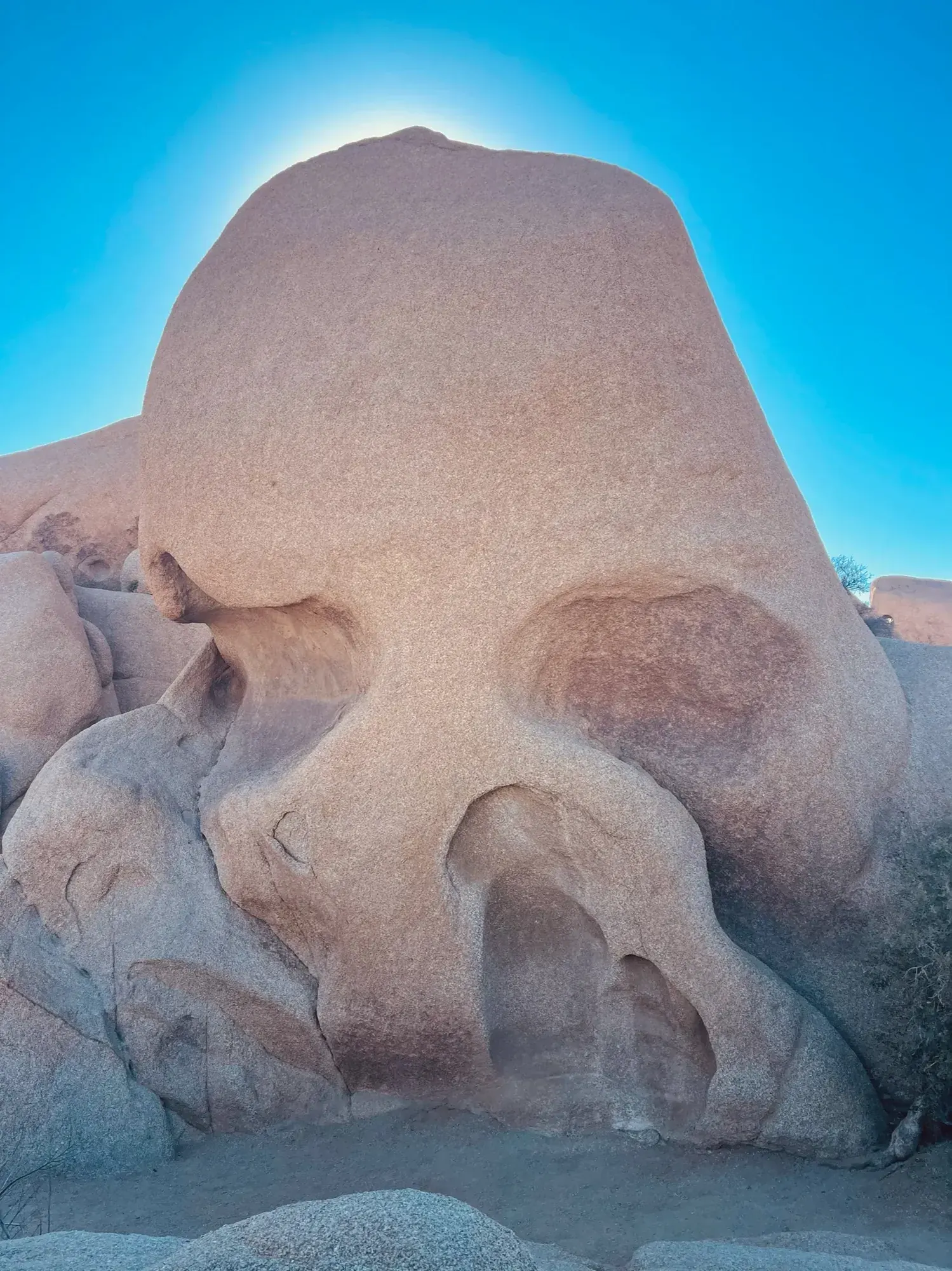
Looking up at Skull Rock. The eye sockets are what make it. · Mar 2021 · Our photo
Stay near Twentynine Palms makes a practical base for the North Entrance and this side of the park. Source
3 days
Make time for Cholla Cactus Garden
Add your dates and save a copy.
Day 1 · Hidden Valley and the western Park Boulevard stops
Start with the exposed walks while it is cool. If parking is tight at Hidden Valley or Barker Dam, choose one loop and keep the overlook optional. Access source
-
Hidden Valley
Start with the short loop among the boulders. If the lot is full, move on to Cap Rock and check for a space later.
Our tip If you only have one day: morning — Hidden Valley, Barker Dam, and the Ryan Mountain hike; midday — Jumbo Rocks lunch, Skull Rock, and Arch Rock; evening — Cholla Cactus Garden, Keys View sunset, and stargazing. David & Keri
Facts for Hidden Valley
The trail starts near Hidden Valley Picnic Area and loops past interpretive signs about the area, plants and wildlife. Keep the named trail separate from climbing routes or informal paths among boulders. Its mile and gain figures do not describe unrestricted exploration of the rocks. 1
- Distance
- 1-mile loop (NPS). 1
- Elevation
- Approximately 100 feet elevation gain (NPS). 1
- Time
- 30–60 minutes (NPS activity). 1
- Difficulty
- Easy rating; dirt, sand, gravel, rocks and boulder steps. 1
- Route
- loop 1
- Trailhead
- Hidden Valley Picnic Area. 1
- Where
- Park Boulevard 1
- Walking
- 1 mi loop 1
- Season
- Year-round 1
- Dogs
- Not allowed 1
- Accessibility
- Pets are not allowed on this trail, but service animals are welcome. Service animals must remain on a 6-foot (1.8 meter) leash at all times. This trail meanders through a variety of terrain… 1
- Access features
- Restroom - Accessible 2
-
Barker Dam
Walk the loop if the lot has space. Keep your distance from rock art and expect little shade.
Facts for Barker Dam
The dam is not a promise of water. NPS says the reservoir occasionally fills after heavy rain and is typically dry much of the year. Rock formations, Joshua trees and interpretive signs offer reasons to visit even when it is dry. 1
- Distance
- 1.1-mile loop (NPS). 1
- Elevation
- The NPS doesn’t publish the elevation gain. 1
- Time
- 30–60 minutes (NPS activity). 1
- Difficulty
- Boulder steps and sand; wheelchairs not accessible; strollers prohibited in NPS record. 1
- Route
- loop 1
- Trailhead
- Barker Dam parking area. 1
- Where
- Barker Dam Nature Trail 1
- Walking
- 1.1 mi loop 1
- Season
- Year-round 1
- Dogs
- Not allowed 1
- Accessibility
- Barker Dam Trail begins on flat, compact dirt, but slowly begins to incline and transitions into granite boulders to step on or over. Some boulders have steps, other small boulders do not. The trail… 1
- Access features
- Restroom - Accessible 2
-
Keys View
Take the paved road to the overlook for a view of the Coachella Valley if visibility is good.
Stay near Use Joshua Tree for a West Entrance start, or Twentynine Palms if you plan to enter from the north. Source
Day 2 · Ryan Mountain or a shorter morning at Cap Rock
Skip Ryan Mountain in hot conditions. Cap Rock is the shorter option if it is cool enough to walk, or head to a visitor center when outdoor conditions are unsafe. If you are based near Yucca Valley, Black Rock is another option in cool conditions. Access source
2 stops in order. Positions from OpenStreetMap; map data loads from OpenStreetMap when you tap. Not for navigation.
-
Ryan Mountain
Give the exposed summit hike the cool part of the morning. Bring water and turn back if conditions change.
Facts for Ryan Mountain
A difficult three-mile out-and-back climb with little shade and panoramic views in central Joshua Tree. 1
- Distance
- 3 miles out and back. 1
- Elevation
- 1,050 feet of elevation gain in the NPS trailhead place record. 2
- Time
- 2–3 hours in the activity record. 1
- Difficulty
- Difficult; rough dirt and rock, many steps and steep sections. 1
- Route
- out-and-back 1
- Trailhead
- Ryan Mountain Trailhead on Park Boulevard between Ryan and Sheep Pass campgrounds. 1
- Season
- Winter, Spring, Fall 1
- Dogs
- Not allowed 1
- Accessibility
- This hike is on a rough dirt and rock trail with many steps and steep sections. Pets are not allowed on this trail, but service animals are welcome. Service animals must remain on a 6-foot (1.8… 1
- Access features
- Restroom - Accessible 2
-
Cap Rock
Use this short loop as a substitute for Ryan Mountain, or add it after the hike if conditions are still comfortable.
Facts for Cap Rock
An easy .4-mile loop hike 1
Stay near Use Joshua Tree for a West Entrance start, or Twentynine Palms if you plan to enter from the north. Source
Day 3 · Cholla Cactus Garden and Skull Rock
Check Pinto Basin Road and the garden before driving in. If access is closed, try the Oasis of Mara in Twentynine Palms instead. If you are exiting to Interstate 10, Cottonwood Spring can replace Skull Rock when the south road is open. Access source
-
Cholla Cactus Garden
Walk the short loop in closed-toe shoes and keep clear of cactus segments, including those on the ground. Stay on the trail.
Our tip Get to the Cholla Cactus Garden early for sunset, because the small lot fills at golden hour. Wear closed-toe shoes and don’t touch anything, since the segments break off and stick to you. David & Keri
Facts for Cholla Cactus Garden
See a dense patch of teddy bear cholla with views of Pinto Basin and surrounding mountains. 1
- Time
- 15-30 minutes 2
- Route
- loop 2
- Trailhead
- Cholla Cactus Garden on Pinto Basin Road. 2
- Where
- Pinto Basin Road 1
- Walking
- 0.25 mi walk 1
- Season
- Year-round 1
- Dogs
- Not allowed 1
- Accessibility
- This is a dirt trail that is mostly flat with occasional mild inclines. Pets are not allowed on this trail, but service animals are welcome. Service animals must remain on a 6-foot (1.8 meter) leash… 1
- Access features
- Wheelchair Accessible 3
Source 1 (nps.gov) · Source 2 (nps.gov) · Source 3 (nps.gov)
-
Skull Rock
See the formation from a legal parking space. Make the longer nature loop optional if the day is warming up.
Facts for Skull Rock
See a skull-shaped granite formation and surrounding boulder fields. 1
- Where
- Jumbo Rocks 1
- Walking
- 1.7 mi loop 1
- Time
- 1-2 Hours 1
- Season
- Winter, Spring, Fall 1
- Dogs
- Not allowed 1
- Accessibility
- The Skull Rock Trail contains various terrain types, including deep sand, hard pack dirt, and uneven rocky surfaces. The trail is relatively flat and has a 150 feet total elevation change. The trail… 1
Stay near Twentynine Palms makes a practical base for the North Entrance and this side of the park. Source
Good to know
For your days in Joshua Tree
Wildlife and where to look (3)
- Desert tortoise. Throughout the park; most commonly seen in spring. See from a distance; sightings are uncommon. nps.gov
- Desert bighorn sheep. Rocky mountains and sometimes near water sources such as Barker Dam; early morning and evening. Observe from afar; sightings are uncommon. nps.gov
- Gambel’s quail. Park birding areas include Oasis of Mara, Cottonwood Spring, and Barker Dam.; year-round resident. Check with a ranger about water-source closures before visiting. nps.gov
Night sky and light (3)
- Keys View (Keys View). Parking lots may temporarily close when full. NPS names this as a popular sunset area; congestion can close access on busy days. nps.gov
- Hidden Valley stargazing area (Hidden Valley parking lot). Stay awake and within 20 feet of your vehicle. No parking-lot camping. Designated stargazing area in an International Dark Sky Park. Use red lights. nps.gov
- Pinto Basin Road pullouts (Between Cholla Cactus Garden and Cottonwood). Use roadside pullouts; stay awake within 20 feet of your vehicle. NPS identifies this stretch as having the least traffic and darkest skies. Roadside camping is prohibited. nps.gov
Longer drives between areas (6)
- Joshua Tree Visitor Center to Hidden Valley: 14 miles, 26 minutes. Approximate NPS driving time. nps.gov
- Joshua Tree Visitor Center to Keys View: 21 miles, 37 minutes. Approximate NPS driving time. nps.gov
- Joshua Tree Visitor Center to Cholla Cactus Garden: 36 miles, 56 minutes. Approximate NPS driving time. nps.gov
- Cottonwood Visitor Center to Cholla Cactus Garden: 20 miles, 31 minutes. Approximate NPS driving time. nps.gov
- Joshua Tree National Park Visitor Center, Twentynine Palms to Keys View: 26 miles, 40 minutes. Approximate NPS driving time. nps.gov
- Joshua Tree National Park Visitor Center, Twentynine Palms to Jumbo Rocks Campground: 14 miles, 22 minutes. Approximate NPS driving time. nps.gov
Signal, wifi and charging (3)
- Park interior: Very few areas have coverage; do not rely on phones for navigation or emergencies. nps.gov
- Park visitor centers: Cell service is generally unavailable throughout the park. Free public Wi-Fi at park visitor centers. nps.gov
- Joshua Tree National Park Visitor Center, 6533 Freedom Way, Twentynine Palms: NPS lists five EV charging stations; network and connector types are not specified. nps.gov
As the NPS lists it; coverage changes, so don’t count on a signal on the trail.
Add a guided tour to your Joshua Tree days
Affiliate link: we may earn a commission, at no extra cost to you. How this works
Affiliate link: we may earn a commission, at no extra cost to you. How this works
Before you go
- Joshua Tree permits and reservations: lotteries, campground and lodging booking windows.
- Best time to visit Joshua Tree: crowds, weather and seasonal access by month.
- Plan Joshua Tree in the trip planner: your dates, booking deadlines and a conditions check before you leave.
- Is Joshua Tree open today? Live NPS alerts and closures.
Plans checked against official NPS pages Nov 17, 2026.