Barker Dam
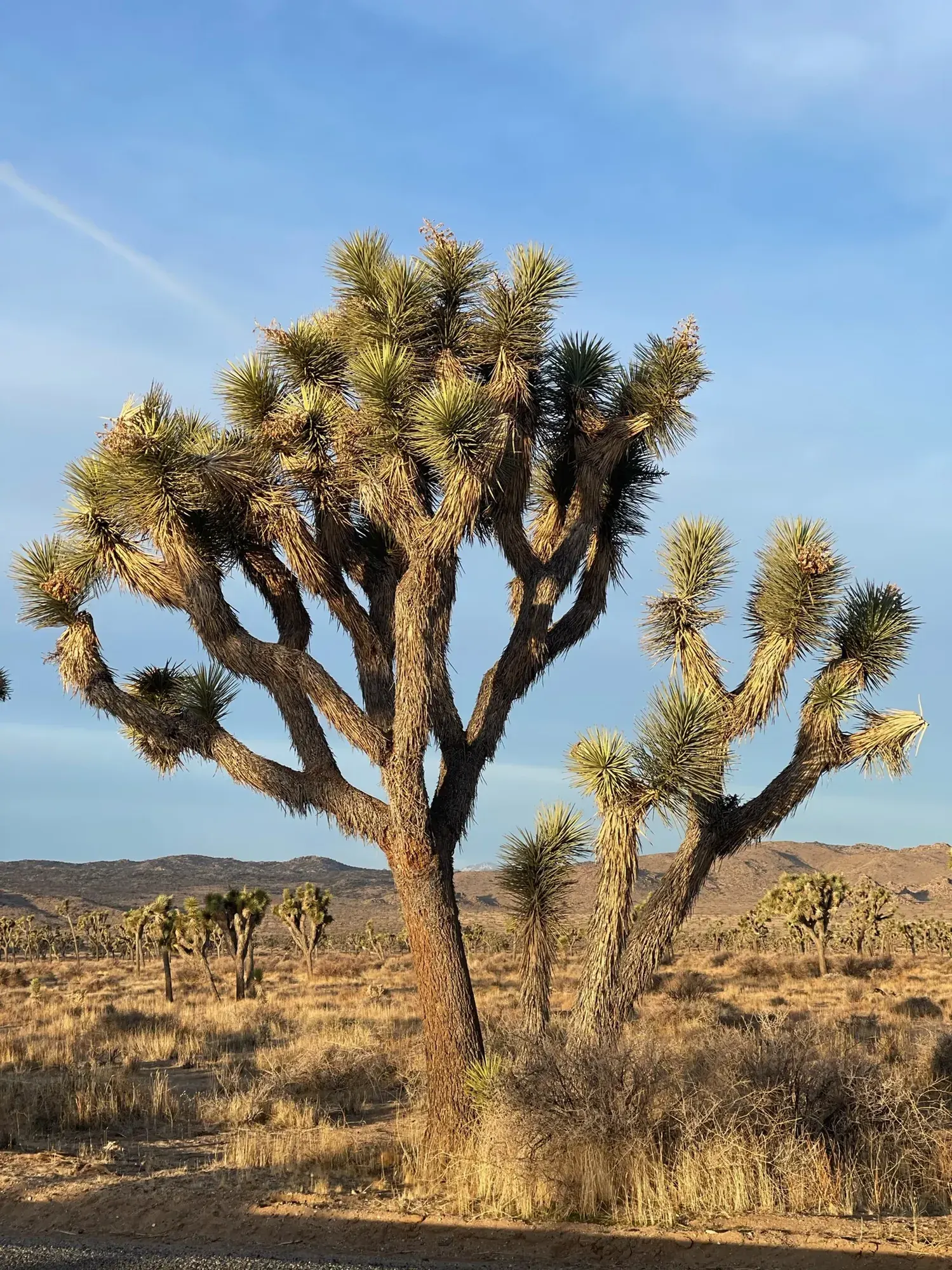
The dam is not a promise of water. NPS says the reservoir occasionally fills after heavy rain and is typically dry much of the year. Rock formations, Joshua trees and interpretive signs offer reasons to visit even when it is dry.
Joshua Tree · Photo: David & Keri New
- 1.1 miDistance
- 30–60 minTime
- EasyDifficulty
The numbers, with sources
Distance: 1.1-mile loop (NPS). Source
Gain: The NPS doesn’t publish the elevation gain. Source
Time: 30–60 minutes (NPS activity). Source
Difficulty: Boulder steps and sand. The NPS says it’s not wheelchair accessible and strollers aren’t allowed. Source
Trailhead: The NPS doesn’t publish this for the whole route. Consult the official route description and park map for the start. Source
Route type: Loop Source
Built from official sources (checked Nov 3, 2026). Confirm current conditions with the park.
Recreation.gov permits, entrances & campgrounds
Recreation.gov (RIDB). Booking records date not published. NPS guidance above takes precedence. A listing doesn’t mean you need a permit or that there’s space on your dates.
Park campground options (9)
These records belong to the park’s NPS recreation area. We haven’t checked how close these are to the trail, when they open or whether sites are free; check the map and the booking page.
COTTONWOOD CAMPGROUND (CA) — Campground; RIDB reservable: yes. Season: not published in structured RIDB data. Recreation.gov (RIDB) source · Booking details
NPS reservation guidance: Reservations are required year-round and can be made up to six months in advance. Book a site at www.recreation.gov or by calling 877-444-6777. NPS source
BLACK ROCK CAMPGROUND — Campground; RIDB reservable: yes. Season: not published in structured RIDB data. Recreation.gov (RIDB) source · Booking details
NPS reservation guidance: Reservations are required year-round and can be made up to six months in advance. Book a site at www.recreation.gov or by calling 877-444-6777. NPS source
SHEEP PASS GROUP — Campground; RIDB reservable: yes. Season: not published in structured RIDB data. Recreation.gov (RIDB) source · Booking details
NPS reservation guidance: Reservations are required year-round and can be made up to six months in advance. Book a site at www.recreation.gov or by calling 877-444-6777. Sites can accommodate 10-60 people. NPS source
Indian Cove Group — Campground; RIDB reservable: yes. Season: not published in structured RIDB data. Recreation.gov (RIDB) source · Booking details
BLACK ROCK EQUESTRIAN CAMPGROUND — Campground; RIDB reservable: yes. Season: not published in structured RIDB data. Recreation.gov (RIDB) source · Booking details
Ryan Campground — Campground; RIDB reservable: yes. Season: not published in structured RIDB data. Recreation.gov (RIDB) source · Booking details
NPS reservation guidance: Reservations are required year-round and can be made up to six months in advance. Book a site at www.recreation.gov or by calling 877-444-6777. NPS source
JUMBO ROCKS CAMPGROUND — Campground; RIDB reservable: yes. Season: not published in structured RIDB data. Recreation.gov (RIDB) source · Booking details
NPS reservation guidance: Reservations are required year-round and can be made up to six months in advance. Book a site at www.recreation.gov or by calling 877-444-6777. NPS source
INDIAN COVE CAMPGROUND — Campground; RIDB reservable: yes. Season: not published in structured RIDB data. Recreation.gov (RIDB) source · Booking details
NPS reservation guidance: Reservations are required year-round and can be made up to six months in advance. Book a site at www.recreation.gov or by calling 877-444-6777. NPS source
COTTONWOOD GROUP — Campground; RIDB reservable: yes. Season: not published in structured RIDB data. Recreation.gov (RIDB) source · Booking details
Route, junction by junction
Route selection → Described destination
The dam is not a promise of water. NPS says the reservoir occasionally fills after heavy rain and is typically dry much of the year. Rock formations, Joshua trees and interpretive signs offer reasons to visit even when it is dry. Source
No elevation profile yet:
No elevation profile yet: we haven’t verified a complete line for this route. No partial line, invented connector, scaled mileage or flat profile is substituted. Source
In-depth guide
Compiled from linked sources, checked Nov 3, 2026. Each paragraph links to its source.
Is this hike for you?
Barker Dam is a relatively flat 1.1-mile loop through the Mojave Desert, past monzogranite rock formations and boulders, Joshua trees, the dam itself and a rock art site. The NPS says it takes 30–60 minutes and doesn’t publish an elevation gain. Don’t count on seeing water: the reservoir sometimes fills after heavy rain but is dry most of the year. Source
The trail
It starts on flat, compact dirt, then climbs gently onto granite boulders you step on or over (some have steps cut in, some don’t). A flat boulder on top gives you the view of Barker Dam. From there you squeeze between or around boulders, go down more granite steps and finish in a sandy wash. The trail averages three feet wide, with an average grade of 1% and a max of 3%. Source
Interpretive signs along the way cover the dam and the desert’s plants, animals and people. The rock art site is a highlight. Much of the art isn’t obvious and can be anywhere on the rock, so don’t touch, step on or climb any part of the formation; view it from the signs. Source
Heat and water
You can hike it year round. In summer expect 100°F and carry at least one liter of water per person. Source
Kids, strollers, wheelchairs and dogs
The trail isn’t accessible for wheelchairs, and strollers aren’t allowed, to protect the fragile desert. Pets aren’t allowed either. Service animals are welcome on a 6-foot (1.8 meter) leash. Source
Maps and elevation
The NPS trail map lists Barker Dam and the Echo T / Barker Dam Connector. OpenStreetMap shows ways labeled “Barker Dam Nature” and “Barker Dam Trail”, but that’s community mapping and doesn’t tell you current access. Source · Source 2 · Source 3 · Source 4
There’s no elevation profile yet, and the NPS doesn’t say when parking fills or what services are at the trailhead. Source · Source 2
Getting there and back
The NPS doesn’t publish this for the whole route. Consult the official route description and park map for the start. Source
Return: Use the return described in the official route account. Don’t count on a shuttle, boat, flight or pickup unless you have confirmed it yourself. Source
Water
The NPS doesn’t publish a full list of water and restrooms along this route. Use only the facilities explicitly identified in the NPS account; confirm current operations. Source
Hazards
View rock art from the signed area. NPS explains that art may exist on portions of the boulder that are not immediately visible and asks visitors not to touch, step on or climb the formation. The trail changes from packed dirt to boulder steps and sand, so an easy rating doesn’t mean it’s accessible. Source
Season
This hike can be done year round. Summer hikers should be prepared for 100°F temperatures and have at least one liter of water per person. Source
This hike can be done year round. Summer hikers should be prepared for 100°F temperatures and have at least one liter of water per person. Source
Gear & rules
Respect current closures, signs and barriers. A mapped path is not proof that travel is permitted. Source
Filling a gap in your kit? Compare these packing essentials on Amazon. Choose gear for your route, conditions and the park’s guidance.
As an Amazon Associate we earn from qualifying purchases. How this works
The NPS doesn’t publish a pet rule for this exact route; confirm with the park before bringing an animal. Source
Questions
Which hike is this?
The dam is not a promise of water. NPS says the reservoir occasionally fills after heavy rain and is typically dry much of the year. Rock formations, Joshua trees and interpretive signs offer reasons to visit even when it is dry. 1.1-mile loop (NPS). Source
Is a measured elevation profile available?
No elevation profile yet: we haven’t verified a complete line for this route. No partial line, invented connector, scaled mileage or flat profile is substituted. Source
Alternatives
Alternative-route distances and durations are unavailable unless separately described in the source. Side trails aren’t included. Source
More Joshua Tree trail guides
- Hidden Valley1 mi · Easy
- Lost Horse Mine Loop6.8 mi · Strenuous
- Ryan Mountain3 mi · Strenuous
- Skull Rock Nature Trail1.7 mi · Strenuous