
Guadalupe MountainsItinerary
Guadalupe Mountains itinerary
A free one-day Guadalupe Mountains itinerary for McKittrick Canyon, with an optional full day for Guadalupe Peak.
By David & Keri New, who have visited 63 of the 64 U.S. national parks
Guadalupe Mountains · Photo: David & Keri New
Choose your days
Spend your first day in McKittrick Canyon. Add a separate summit day if everyone in your group wants the climb and conditions allow it.
Check McKittrick Canyon access and Guadalupe Peak trail conditions before leaving. The canyon gate and the summit trailhead are at different entrances. Check NPS alerts and conditions
David and Keri’s favorite: Guadalupe Peak Trail.
Times are suggested local starts. Closure flags update from the NPS alert feed when available. Check conditions again before your visit. Check park alerts
Open the free one-page planner
1 day
Make time for McKittrick Canyon Trail
Add your dates and save a copy.
Day 1 · McKittrick Canyon · Pratt Cabin and the Grotto
Allow about an hour from Carlsbad, New Mexico, via US 62/180. Use the separate McKittrick Canyon entrance, north of Pine Springs. Drive time source
Plan in Mountain Time and be back through the highway gate before it locks at 5 PM. Check for closures and leave time to turn around early. Access source
-
McKittrick Canyon Trail
Start from the canyon trailhead after the gate opens. Bring water and hike to Pratt Cabin for a 4.8-mile round trip if you turn back there.
-
Pratt Cabin
Pause at the historic cabin. Turn back here for the shorter trip or continue upstream if your group has time and energy.
Facts for Pratt Cabin
Hiking to Pratt Cabin and back (4.8 miles) is the shortest way into the heart of the canyon. You cross the stream once before you reach the historic cabin. Have a snack or lunch at… 1
- Time
- 2-4 hours 1
- Route
- out-and-back 1
- Trailhead
- McKittrick Canyon Trailhead 1
- Season
- Year-round 1
- Fee
- A fee applies; see the NPS page 1
- Dogs
- Not allowed 1
- Accessibility
- Trail surfaces are loose rock or hardened rock surfaces. Hiking or trekking poles are highly recommended. Trail widths vary from two to six feet depending on the trail. Parking All trailhead areas… 1
-
The Grotto and Hunter Line Shack
If continuing, visit the Grotto and the nearby stone cabin. Return the way you came with plenty of time before the gate closes.
Facts for The Grotto and Hunter Line Shack
See exposed cave features, stone picnic tables, and the nearby Hunter Line Shack. 1
- Where
- McKittrick Canyon 1
- Walking
- 7.0 mi round trip 1
- Time
- 3-5 Hours 1
- Season
- Year-round 1
- Fee
- A fee applies; see the NPS page 1
- Dogs
- Not allowed 1
- Accessibility
- Trail surfaces are loose rock or hardened rock surfaces. Hiking or trekking poles are highly recommended. Trail widths vary from two to six feet depending on the trail. Parking All trailhead areas… 1
Optional day 2 · Guadalupe Peak
Make time for Guadalupe Peak Trail
Add this after the 1-day plan.
Add your dates and save a copy.
Day 2 · Guadalupe Peak from Pine Springs
Allow about an hour from Carlsbad to Pine Springs via US 62/180. From Carlsbad Caverns, budget about 45 minutes between the parks. The summit trail starts at Pine Springs, south of the McKittrick Canyon turnoff. Drive time source
Check the forecast, wind and trail alerts before starting. Carry all the water you need. If conditions make the climb unsuitable, skip the summit and use an open lower-elevation trail. Access source
-
Guadalupe Peak Trail
Start at Pine Springs in daylight. The summit hike is strenuous: 8.4 miles round trip, about 3,000 feet of gain, and usually six to eight hours. Set a turnaround time and leave the afternoon for the descent.
Our tip High winds are common on top of Guadalupe Peak, especially in spring, so get the wind forecast before you start up. There’s no water on the trail, so carry all you need. David & Keri
Facts for Guadalupe Peak Trail
Use the main Guadalupe Peak trail for the summit trip and descend the same way. The stock-trail variant adds a mile in each direction and is not the distance used here. 1
- Distance
- 8.4 miles round trip 1
- Elevation
- 3,000 feet of gain 1
- Time
- 6-8 Hours 1
- Difficulty
- Guadalupe Peak is a rewarding, although very strenuous, 8.4 mile round trip hike with a 3,000 foot elevation gain. This is the most popular hike in the park and is often crowded on the weekends. More effort is required to hike at higher elevations due to the reduced amount of oxygen available in the air. Remember that at 8,000 feet you are at risk of altitude illness , a potentially life-threatening condition. Search and Rescue Policy Search and rescue actions are conducted on a discretionary basis. The level and necessity of the response is determined through evaluation of the situation by field personnel. Rescuer safety is always our first priority. This park expects visitors to exhibit a high degree of self-reliance and responsibility for their own safety in line with the difficulty of their chosen activities. If you choose to carry a hand-held electronic signaling device, be familiar with its operation, limitations, and frequency of failure to transmit. Do not rely on it to summon rescue personnel or notify family that you are “OK”. The device only acts as a communication link. All decisions regarding rescue will fall to park field staff. If you do activate the emergency help function on the device, understand the consequences of what you may be asking of rescue personnel. If you find yourself in a true emergency and have exhausted all means of self-rescue/help, contact a ranger in the field or call Texas DPS Pecos Dispatch (432) 447-3533. There is little to no cell reception in most areas of the park. When you make contact, provide clear and concise information regarding the nature and exact location of the problem or injury, as well as the number of people involved. Be aware that help may be several hours to several days out. You must be prepared to help yourself. If you have any questions, please contact the Visitor Center at (915) 828-3251. 1
- Route
- out-and-back 1
- Trailhead
- Pine Springs Trailhead, half a mile from Pine Springs Visitor Center. 1
- Season
- Year-round 1
- Fee
- A fee applies; see the NPS page 1
- Dogs
- Not allowed 1
- Accessibility
- Trail surfaces are loose rock or hardened rock surfaces. Hiking or trekking poles are highly recommended. Trail widths vary from two to six feet depending on the trail. Parking All trailhead areas… 1
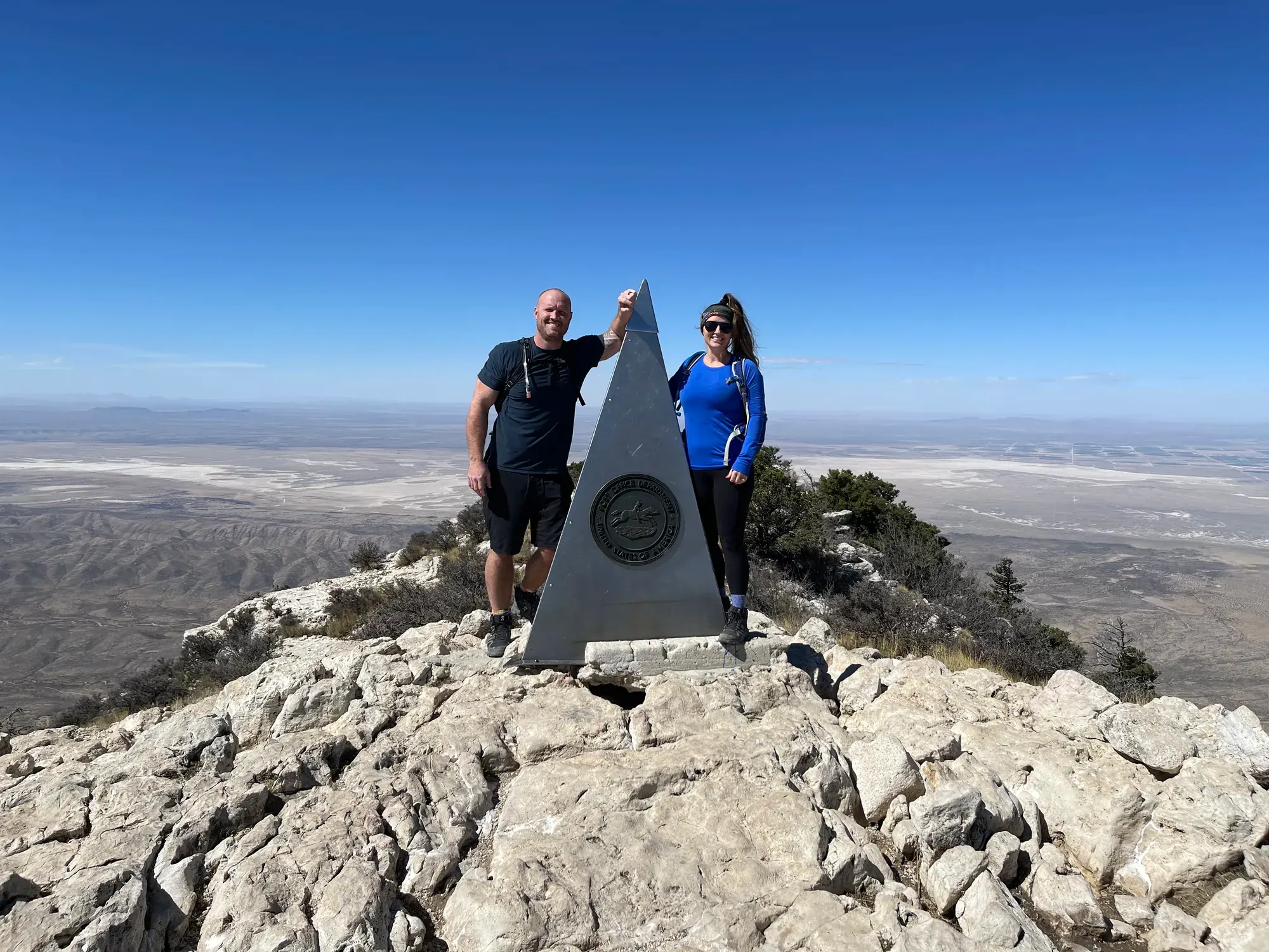
Keri and me at the steel pyramid on Guadalupe Peak, the highest point in Texas. · Mar 2022 · Our photo
Good to know
For your days in Guadalupe Mountains
Wildlife and where to look (4)
- Mule deer. Trees and shrubs throughout the park; early morning or late evening. Look for deer browsing on trees and shrubs. nps.gov
- Rock squirrel. Rocky canyons and washes; early morning and late afternoon. Look for squirrels foraging in trees for fruit, nuts, and seeds. nps.gov
- Ringtail. Rocky canyons; evening and night. Look for this nocturnal relative of the raccoon in canyon habitat. nps.gov
- Black bear. Mountaintop Douglas fir and ponderosa pine forests. Bears are shy and rarely seen; do not expect a sighting. nps.gov
Night sky and light (2)
- Guadalupe Peak (Guadalupe Peak summit). Strenuous 8.4 mi round-trip hike; carry a headlamp or flashlight for darkness. NPS identifies the summit for sunrise and sunset views; exposed high elevations have lightning and wind hazards. nps.gov
- McKittrick Ridge Wilderness Campground (McKittrick Ridge). Strenuous backpacking trip to the wilderness campground. NPS identifies night skies as a reason to stay overnight. nps.gov
Longer drives between areas (4)
- El Paso, Texas to Pine Springs: 110 miles, . Via U.S. 62/180. nps.gov
- Carlsbad, New Mexico to Pine Springs: 56 miles, . Via U.S. 62/180. nps.gov
- Van Horn, Texas to Pine Springs: 62 miles, . Via Highway 54 and U.S. 62/180. nps.gov
- Pine Springs to Dog Canyon: 2 hours. Access the north district via New Mexico State Road 137. nps.gov
Add a guided tour to your Guadalupe Mountains days
Affiliate link: we may earn a commission, at no extra cost to you. How this works
Before you go
- Best time to visit Guadalupe Mountains: crowds, weather and seasonal access by month.
- Plan Guadalupe Mountains in the trip planner: your dates, booking deadlines and a conditions check before you leave.
- Is Guadalupe Mountains open today? Live NPS alerts and closures.
Plans checked against official NPS pages Nov 10, 2026.