
Death ValleyItinerary
Death Valley itinerary
Free 1-, 2-, 3-, and 5-day Death Valley plans, with heat and road checks before each trip.
By David & Keri New, who have visited 63 of the 64 U.S. national parks
Death Valley · Photo: David & Keri New
Choose your days
Start at Zabriskie Point, then visit Golden Canyon and Badwater if conditions are cool. Add Artists Drive and Dantes View on day two and the dunes on day three. With five days, give Ubehebe Crater and the Furnace Creek area separate days.
Times are suggested local starts. Closure flags update from the NPS alert feed when available. Check conditions again before your visit. Check park alerts
Open the free one-page planner
1 day
Make time for Golden Canyon, Gower Gulch and Badlands Loop
Add your dates and save a copy.
Day 1 · Zabriskie Point, Golden Canyon, and Badwater
These hikes are for cool conditions. Skip valley-floor hiking in hot weather, even early if it is already hot, and stay out of canyons when flash flooding is possible. Bring extra water and check road and weather alerts before driving. Access source
2 stops in order; not on the map: Golden Canyon, Gower Gulch and Badlands Loop (not one fixed place, or no reliable position). Positions from OpenStreetMap; map data loads from OpenStreetMap when you tap. Not for navigation.
-
Zabriskie Point
Time the short paved climb to the overlook for local sunrise if conditions allow. Keep this as a viewpoint stop before driving to the Golden Canyon trailhead.
Our tip If you only have one day, do the Mesquite Flat dunes, Mosaic Canyon, and Zabriskie Point. David & Keri
-
Golden Canyon, Gower Gulch and Badlands Loop
Start at the Golden Canyon trailhead on Badwater Road. Use the NPS map to choose a route for your group. The linked canyon and badlands routes vary in length and difficulty. Skip the hike if it is hot, rain threatens, or the trail is closed.
-
Badwater Basin
Stop at the boardwalk and see the salt flats. Walk beyond the boardwalk only in cool, safe conditions. If the heat makes even a short stop unsafe, save Badwater for a cooler visit.
Facts for Badwater Basin
See salt flats at the lowest elevation in North America, 282 feet below sea level. 1
- Where
- Badwater Road 1
- Walking
- 0.25 mi walk to salt polygons; no designated trail 1
- Time
- 1-2 Hours 1
- Season
- Winter, Spring, Fall 1
- Fee
- A fee applies; see the NPS page 1
- Dogs
- Not allowed 1
- Accessibility
- Badwater Basin can be viewed from your vehicle in the parking area. Exiting your vehicle and accessing the wooden boardwalk can be done by a short, paved ramp. The wooden boardwalk is older wood, so… 1
- Access features
- Wheelchair Accessible 2
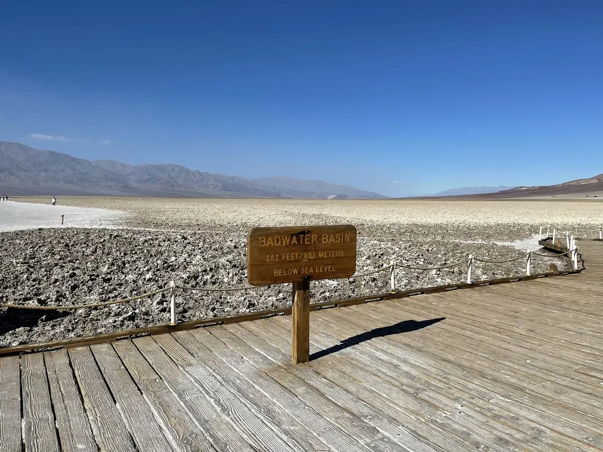
The boardwalk at Badwater Basin where the salt flats open up in front of you. · Our photo
Stay near Furnace Creek for the central valley, Badwater Road, and the CA-190 viewpoints. Confirm lodging or camping before you go. Source
2 days
Make time for Golden Canyon, Gower Gulch and Badlands Loop
Add your dates and save a copy.
Day 1 · Zabriskie Point, Golden Canyon, and Badwater
These hikes are for cool conditions. Skip valley-floor hiking in hot weather, even early if it is already hot, and stay out of canyons when flash flooding is possible. Bring extra water and check road and weather alerts before driving. Access source
2 stops in order; not on the map: Golden Canyon, Gower Gulch and Badlands Loop (not one fixed place, or no reliable position). Positions from OpenStreetMap; map data loads from OpenStreetMap when you tap. Not for navigation.
-
Zabriskie Point
Time the short paved climb to the overlook for local sunrise if conditions allow. Keep this as a viewpoint stop before driving to the Golden Canyon trailhead.
Our tip If you only have one day, do the Mesquite Flat dunes, Mosaic Canyon, and Zabriskie Point. David & Keri
-
Golden Canyon, Gower Gulch and Badlands Loop
Start at the Golden Canyon trailhead on Badwater Road. Use the NPS map to choose a route for your group. The linked canyon and badlands routes vary in length and difficulty. Skip the hike if it is hot, rain threatens, or the trail is closed.
-
Badwater Basin
Stop at the boardwalk and see the salt flats. Walk beyond the boardwalk only in cool, safe conditions. If the heat makes even a short stop unsafe, save Badwater for a cooler visit.
Facts for Badwater Basin
See salt flats at the lowest elevation in North America, 282 feet below sea level. 1
- Where
- Badwater Road 1
- Walking
- 0.25 mi walk to salt polygons; no designated trail 1
- Time
- 1-2 Hours 1
- Season
- Winter, Spring, Fall 1
- Fee
- A fee applies; see the NPS page 1
- Dogs
- Not allowed 1
- Accessibility
- Badwater Basin can be viewed from your vehicle in the parking area. Exiting your vehicle and accessing the wooden boardwalk can be done by a short, paved ramp. The wooden boardwalk is older wood, so… 1
- Access features
- Wheelchair Accessible 2
Stay near Furnace Creek for the central valley, Badwater Road, and the CA-190 viewpoints. Confirm lodging or camping before you go. Source
Day 2 · Artists Drive and Dantes View
Check both roads in the park alerts before leaving. Vehicles over 9 feet wide or 25 feet in total length, including anything towed, cannot use these roads. If either road is closed or your vehicle exceeds the limits, use an open CA-190 viewpoint such as Zabriskie Point. Access source
-
Artists Drive
Follow the paved one-way loop when open. Stop at the Artists Palette parking area for the view and allow time to return to CA-190 before heading east.
Facts for Artists Drive
Artists Drive is a one-way, nine mile (14.5 km) drive through eroded, colorful desert hills. Artists Palette (a viewpoint) has the most color along the road. 1
-
Dantes View
Use the overlook above Badwater Basin. Adjust the start to local sunset if you want the evening light, and bring a layer for wind at elevation.
Facts for Dantes View
See Badwater Basin and the Panamint Range from a viewpoint 5,575 feet above the basin. 1
Stay near Furnace Creek for the central valley, Badwater Road, and the CA-190 viewpoints. Confirm lodging or camping before you go. Source
3 days
Make time for Golden Canyon, Gower Gulch and Badlands Loop
Add your dates and save a copy.
Day 1 · Zabriskie Point, Golden Canyon, and Badwater
These hikes are for cool conditions. Skip valley-floor hiking in hot weather, even early if it is already hot, and stay out of canyons when flash flooding is possible. Bring extra water and check road and weather alerts before driving. Access source
2 stops in order; not on the map: Golden Canyon, Gower Gulch and Badlands Loop (not one fixed place, or no reliable position). Positions from OpenStreetMap; map data loads from OpenStreetMap when you tap. Not for navigation.
-
Zabriskie Point
Time the short paved climb to the overlook for local sunrise if conditions allow. Keep this as a viewpoint stop before driving to the Golden Canyon trailhead.
Our tip If you only have one day, do the Mesquite Flat dunes, Mosaic Canyon, and Zabriskie Point. David & Keri
-
Golden Canyon, Gower Gulch and Badlands Loop
Start at the Golden Canyon trailhead on Badwater Road. Use the NPS map to choose a route for your group. The linked canyon and badlands routes vary in length and difficulty. Skip the hike if it is hot, rain threatens, or the trail is closed.
-
Badwater Basin
Stop at the boardwalk and see the salt flats. Walk beyond the boardwalk only in cool, safe conditions. If the heat makes even a short stop unsafe, save Badwater for a cooler visit.
Facts for Badwater Basin
See salt flats at the lowest elevation in North America, 282 feet below sea level. 1
- Where
- Badwater Road 1
- Walking
- 0.25 mi walk to salt polygons; no designated trail 1
- Time
- 1-2 Hours 1
- Season
- Winter, Spring, Fall 1
- Fee
- A fee applies; see the NPS page 1
- Dogs
- Not allowed 1
- Accessibility
- Badwater Basin can be viewed from your vehicle in the parking area. Exiting your vehicle and accessing the wooden boardwalk can be done by a short, paved ramp. The wooden boardwalk is older wood, so… 1
- Access features
- Wheelchair Accessible 2
Stay near Furnace Creek for the central valley, Badwater Road, and the CA-190 viewpoints. Confirm lodging or camping before you go. Source
Day 2 · Artists Drive and Dantes View
Check both roads in the park alerts before leaving. Vehicles over 9 feet wide or 25 feet in total length, including anything towed, cannot use these roads. If either road is closed or your vehicle exceeds the limits, use an open CA-190 viewpoint such as Zabriskie Point. Access source
-
Artists Drive
Follow the paved one-way loop when open. Stop at the Artists Palette parking area for the view and allow time to return to CA-190 before heading east.
Facts for Artists Drive
Artists Drive is a one-way, nine mile (14.5 km) drive through eroded, colorful desert hills. Artists Palette (a viewpoint) has the most color along the road. 1
-
Dantes View
Use the overlook above Badwater Basin. Adjust the start to local sunset if you want the evening light, and bring a layer for wind at elevation.
Facts for Dantes View
See Badwater Basin and the Panamint Range from a viewpoint 5,575 feet above the basin. 1
Stay near Furnace Creek for the central valley, Badwater Road, and the CA-190 viewpoints. Confirm lodging or camping before you go. Source
Day 3 · Mesquite Flat Sand Dunes and Mosaic Canyon
Start in the coolest part of the morning. Check the unpaved Mosaic Canyon Road, especially after storms. Skip the canyon when flooding is possible or the road is unsuitable for your vehicle. Use the dunes viewpoint only if conditions are safe. Access source
2 stops in order. Positions from OpenStreetMap; map data loads from OpenStreetMap when you tap. Not for navigation.
-
Mesquite Flat Sand Dunes
Enjoy the early light near the parking area. In cool conditions, walk a short way onto the sand and leave plenty of energy for the return. The high dune is optional.
Facts for Mesquite Flat Sand Dunes
See wind-shaped sand dunes and mesquite trees against surrounding mountains. 1
-
Mosaic Canyon
If the approach is open and suitable, walk to the first marble narrows and turn back. This short version leaves the scrambling farther up the canyon for another trip.
Facts for Mosaic Canyon
A four-mile out-and-back canyon route through polished narrows and scrambling obstacles to an impassable dryfall. 1
- Distance
- 4 miles round trip for the full described route. 1
- Elevation
- 1,200 feet in the NPS route summary. 1
- Time
- 2.5–3 hours round trip. 1
- Difficulty
- Moderate, with scrambling and slick winding narrows. 1
- Route
- out-and-back 2
- Trailhead
- Mosaic Canyon parking area, 2.3 miles up unpaved Mosaic Canyon Road opposite Stovepipe Wells Campground. 2
Stay near Stovepipe Wells for the dunes and Mosaic Canyon, or stay in Furnace Creek and allow for the drive west on CA-190. Source
5 days
Make time for Golden Canyon, Gower Gulch and Badlands Loop
Add your dates and save a copy.
Day 1 · Zabriskie Point, Golden Canyon, and Badwater
These hikes are for cool conditions. Skip valley-floor hiking in hot weather, even early if it is already hot, and stay out of canyons when flash flooding is possible. Bring extra water and check road and weather alerts before driving. Access source
2 stops in order; not on the map: Golden Canyon, Gower Gulch and Badlands Loop (not one fixed place, or no reliable position). Positions from OpenStreetMap; map data loads from OpenStreetMap when you tap. Not for navigation.
-
Zabriskie Point
Time the short paved climb to the overlook for local sunrise if conditions allow. Keep this as a viewpoint stop before driving to the Golden Canyon trailhead.
Our tip If you only have one day, do the Mesquite Flat dunes, Mosaic Canyon, and Zabriskie Point. David & Keri
-
Golden Canyon, Gower Gulch and Badlands Loop
Start at the Golden Canyon trailhead on Badwater Road. Use the NPS map to choose a route for your group. The linked canyon and badlands routes vary in length and difficulty. Skip the hike if it is hot, rain threatens, or the trail is closed.
-
Badwater Basin
Stop at the boardwalk and see the salt flats. Walk beyond the boardwalk only in cool, safe conditions. If the heat makes even a short stop unsafe, save Badwater for a cooler visit.
Facts for Badwater Basin
See salt flats at the lowest elevation in North America, 282 feet below sea level. 1
- Where
- Badwater Road 1
- Walking
- 0.25 mi walk to salt polygons; no designated trail 1
- Time
- 1-2 Hours 1
- Season
- Winter, Spring, Fall 1
- Fee
- A fee applies; see the NPS page 1
- Dogs
- Not allowed 1
- Accessibility
- Badwater Basin can be viewed from your vehicle in the parking area. Exiting your vehicle and accessing the wooden boardwalk can be done by a short, paved ramp. The wooden boardwalk is older wood, so… 1
- Access features
- Wheelchair Accessible 2
Stay near Furnace Creek for the central valley, Badwater Road, and the CA-190 viewpoints. Confirm lodging or camping before you go. Source
Day 2 · Artists Drive and Dantes View
Check both roads in the park alerts before leaving. Vehicles over 9 feet wide or 25 feet in total length, including anything towed, cannot use these roads. If either road is closed or your vehicle exceeds the limits, use an open CA-190 viewpoint such as Zabriskie Point. Access source
-
Artists Drive
Follow the paved one-way loop when open. Stop at the Artists Palette parking area for the view and allow time to return to CA-190 before heading east.
Facts for Artists Drive
Artists Drive is a one-way, nine mile (14.5 km) drive through eroded, colorful desert hills. Artists Palette (a viewpoint) has the most color along the road. 1
-
Dantes View
Use the overlook above Badwater Basin. Adjust the start to local sunset if you want the evening light, and bring a layer for wind at elevation.
Facts for Dantes View
See Badwater Basin and the Panamint Range from a viewpoint 5,575 feet above the basin. 1
Stay near Furnace Creek for the central valley, Badwater Road, and the CA-190 viewpoints. Confirm lodging or camping before you go. Source
Day 3 · Mesquite Flat Sand Dunes and Mosaic Canyon
Start in the coolest part of the morning. Check the unpaved Mosaic Canyon Road, especially after storms. Skip the canyon when flooding is possible or the road is unsuitable for your vehicle. Use the dunes viewpoint only if conditions are safe. Access source
2 stops in order. Positions from OpenStreetMap; map data loads from OpenStreetMap when you tap. Not for navigation.
-
Mesquite Flat Sand Dunes
Enjoy the early light near the parking area. In cool conditions, walk a short way onto the sand and leave plenty of energy for the return. The high dune is optional.
Facts for Mesquite Flat Sand Dunes
See wind-shaped sand dunes and mesquite trees against surrounding mountains. 1
-
Mosaic Canyon
If the approach is open and suitable, walk to the first marble narrows and turn back. This short version leaves the scrambling farther up the canyon for another trip.
Facts for Mosaic Canyon
A four-mile out-and-back canyon route through polished narrows and scrambling obstacles to an impassable dryfall. 1
- Distance
- 4 miles round trip for the full described route. 1
- Elevation
- 1,200 feet in the NPS route summary. 1
- Time
- 2.5–3 hours round trip. 1
- Difficulty
- Moderate, with scrambling and slick winding narrows. 1
- Route
- out-and-back 2
- Trailhead
- Mosaic Canyon parking area, 2.3 miles up unpaved Mosaic Canyon Road opposite Stovepipe Wells Campground. 2
Stay near Stovepipe Wells for the dunes and Mosaic Canyon, or stay in Furnace Creek and allow for the drive west on CA-190. Source
Day 4 · Ubehebe Crater and the north valley
Fuel up and carry food and water before heading north. Check North Highway and Ubehebe Crater Road in the NPS status map. If access is closed, use the Furnace Creek day instead. Follow posted closures around Scotty’s Castle. Access source
-
Ubehebe Crater
Start at the parking-area overlook. Walk the rim loop only in cool weather with manageable wind and good footing. Stay back from the edge and skip the descent into the crater.
Facts for Ubehebe Crater
See a volcanic explosion crater and exposed layers of sedimentary rock. 1
Stay near Stovepipe Wells for the dunes and Mosaic Canyon, or stay in Furnace Creek and allow for the drive west on CA-190. Source
Day 5 · Salt Creek and Furnace Creek history
Check Salt Creek Road after rain and confirm the boardwalk is open. If access is closed, spend more time at the visitor center if it is open. Keep outdoor stops short in warm weather. Access source
3 stops in order. Positions from OpenStreetMap, NPS visitor center listing; map data loads from OpenStreetMap when you tap. Not for navigation.
-
Salt Creek
Use the boardwalk if open and stay on it to protect the creek habitat. Check the road before leaving the highway.
-
Harmony Borax Works
Follow the short interpretive route to see remnants of the borax operation and learn about the wagon teams.
Facts for Harmony Borax Works
See historic borax-processing remains and learn about the 20-mule teams from interpretive panels. 1
-
Furnace Creek Visitor Center
If the visitor center is open, see the exhibits and ask about road, weather, and trail conditions before continuing.
Facts for Furnace Creek Visitor Center
Stop by the visitor center to speak with park rangers and pay park fees and purchase national park passes. View the exhibits about Death Valley’s history and natural wonders. Watch the park film, which is 20 minutes in length and plays… 1
- Time
- 15-120 Minutes 1
- Fee
- A fee applies; see the NPS page 1
- Dogs
- Not allowed 1
- Accessibility
- ADA- assisted listening and audio description devices are available for the park film and visitor center exhibits. 1
- Hours
- Daily 8:00AM - 5:00PM (standard week) 1
- At the center
- Food/Drink - Snacks, Gifts/Souvenirs/Books, Historical/Interpretive Information/Exhibits, Information, Information - Maps Available, Information - Park Newspaper Available 1
- Passport stamp
- Green ink with words “Death Valley National Park,” “Death Valley, CA,” and full date in center. 1
- Access features
- Assistive Listening Systems, Automated Entrance, Captioned Media, Restroom - Accessible, Tactile Exhibit, Wheelchair Accessible 1
Stay near Furnace Creek for the central valley, Badwater Road, and the CA-190 viewpoints. Confirm lodging or camping before you go. Source
Good to know
For your days in Death Valley
Wildlife and where to look (4)
- Coyote. Salt flats into mountains; common around mesquite thickets.. Look around mesquite habitat. nps.gov
- Kit fox. Sand dunes and Furnace Creek; found throughout much of Death Valley.; night. Look after dark; this species is nocturnal. nps.gov
- Desert cottontail. Mesquite thickets on the valley floor.. Look around valley-floor mesquite habitat. nps.gov
- Salt Creek pupfish. Salt Creek; winter 2026-27: cooler months support spawning; access information conflicts.. Stay on the boardwalk to protect the fragile creek habitat. nps.gov
Night sky and light (4)
- Zabriskie Point (CA-190 east of Furnace Creek). 0.25 mi uphill paved walk from parking. NPS identifies sunrise and sunset as favored viewing times. nps.gov
- Dantes View (Black Mountains above Badwater Basin). Viewpoint parking; optional ridge walk. NPS highlights sunrise and sunset photography here. nps.gov
- Mesquite Flat Sand Dunes (East of Stovepipe Wells off CA-190). Paved parking; cross-country walking on sand. Sunrise and sunset shadows emphasize dune ripples and edges. nps.gov
- Harmony Borax Works (Near Furnace Creek). Park has no closing time; visit after dark. Ranger-recommended stargazing location in this Gold Tier International Dark Sky Park. Use a red light. nps.gov
Longer drives between areas (8)
- Furnace Creek to Badwater Basin: 17 miles, 30 minutes. Via Badwater Road. nps.gov
- Furnace Creek to Mesquite Flat Sand Dunes: 24 miles, 30 minutes. West toward Stovepipe Wells. nps.gov
- Furnace Creek Visitor Center to Zabriskie Point: 15 minutes. East on CA-190. nps.gov
- Furnace Creek to Dantes View: 45 minutes. Detour off CA-190. nps.gov
- Furnace Creek to Ubehebe Crater: 1 hour. NPS published drive estimate. nps.gov
- Furnace Creek Visitor Center to Beatty, Nevada: about 45 minutes. NPS approximate travel time. nps.gov
- Furnace Creek Visitor Center to Las Vegas, Nevada: about 2.5 hours. NPS approximate travel time. nps.gov
- Furnace Creek Visitor Center to Lone Pine, California: about 1 hour 45 minutes. NPS approximate travel time. nps.gov
Signal, wifi and charging (4)
- Furnace Creek lodging area: NPS lodging page lists four chargers each at The Inn and The Ranch; recommends overnight use. Operating status conflicts with older directions page. nps.gov
- Stovepipe Wells: Four Blink Series 8 Plus chargers beside the General Store; SAE J1772 connectors. nps.gov
- Panamint Springs Resort: . nps.gov
- Park roads and Furnace Creek Ranch connectivity: No cell service along most park roads; no service along dirt-road entrances. NPS directions page lists Wi-Fi for purchase at Furnace Creek Ranch. nps.gov
As the NPS lists it; coverage changes, so don’t count on a signal on the trail.
Add a guided tour to your Death Valley days
Affiliate link: we may earn a commission, at no extra cost to you. How this works
Affiliate link: we may earn a commission, at no extra cost to you. How this works
Before you go
- Death Valley permits and reservations: lotteries, campground and lodging booking windows.
- Best time to visit Death Valley: crowds, weather and seasonal access by month.
- Plan Death Valley in the trip planner: your dates, booking deadlines and a conditions check before you leave.
- Is Death Valley open today? Live NPS alerts and closures.
Plans checked against official NPS pages Nov 10, 2026.