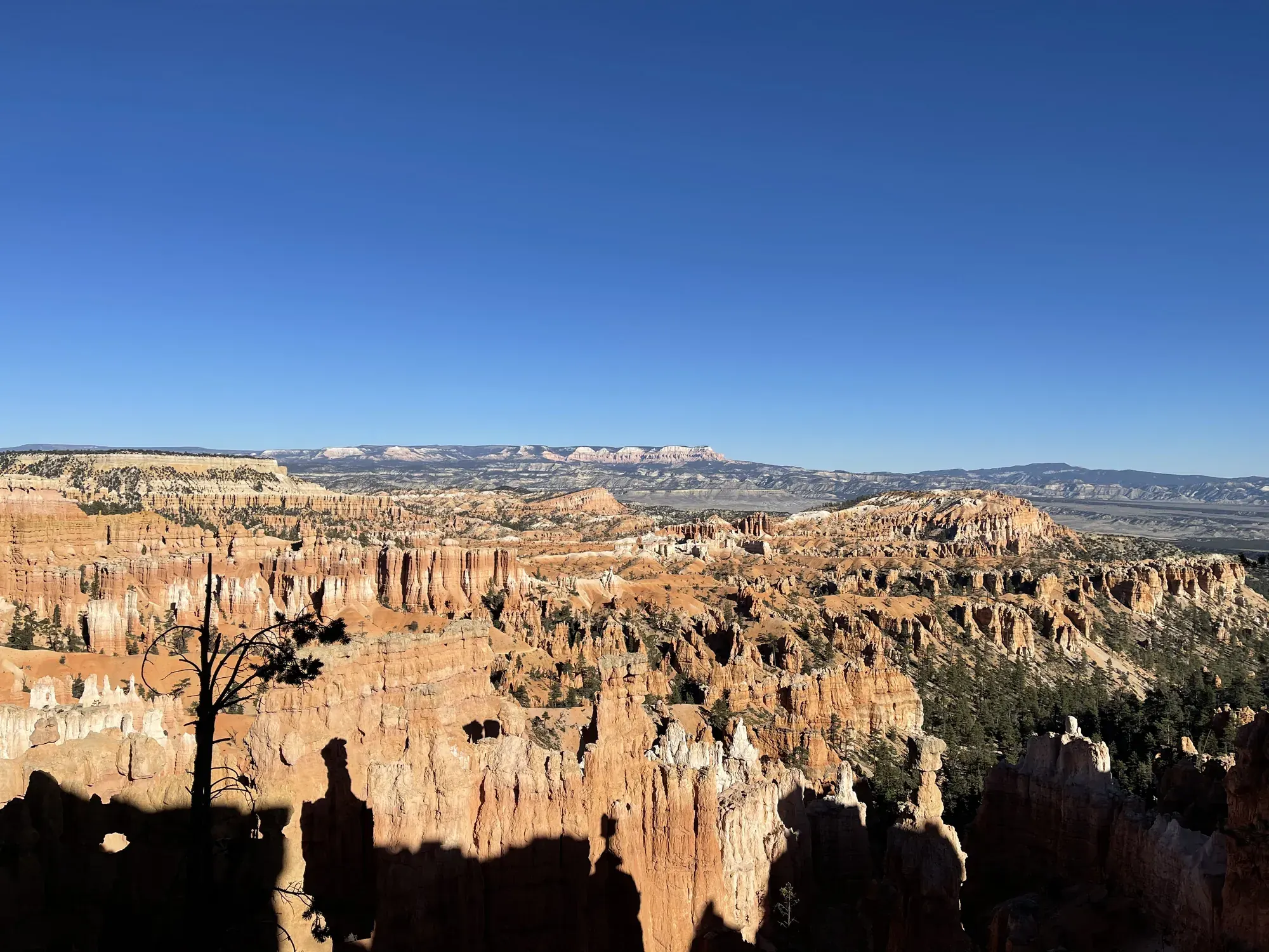
Queen’s Garden/Navajo Combination Loop
This loop combines Queen’s Garden and Navajo Loop with the Rim Trail. NPS recommends descending at Sunrise Point and ascending to Sunset Point in a clockwise direction.
Bryce Canyon · Photo: David & Keri New
- 2.9 miDistance
- 625 ftElevation gain
- 2–3 hrTime
- ModerateDifficulty
The numbers, with sources
Distance: 2.9 mi loop. Source
Gain: 625 ft. Source
Time: 2–3 hours. Source
Difficulty: Moderate. Source
Trailhead: Sunrise or Sunset Point. Source
Route type: loop Source
Built from official sources (checked Nov 3, 2026). Confirm current conditions with the park.
Recreation.gov permits, entrances & campgrounds
Recreation.gov (RIDB). Booking records date not published. NPS guidance above takes precedence. A listing doesn’t mean you need a permit or that there’s space on your dates.
Nearby campground records
Within 10 straight-line miles of the trailhead. Distances are straight-line from map coordinates, not driving distances.
- North Campground (UT): approximately 0.8 miles straight line. RIDB coordinates · Mapped route source
- Sunset Campground (UT): approximately 0.8 miles straight line. RIDB coordinates · Mapped route source
Park campground options (2)
These records belong to the park’s NPS recreation area. We haven’t checked how close these are to the trail, when they open or whether sites are free; check the map and the booking page.
North Campground (UT) — Campground; RIDB reservable: yes. Season: not published in structured RIDB data. Recreation.gov (RIDB) source · Booking details
Sunset Campground (UT) — Campground; RIDB reservable: yes. Season: not published in structured RIDB data. Recreation.gov (RIDB) source · Booking details
Route, junction by junction
Sunrise Point → Queen’s Garden spur
Start near Sunrise Point and descend Queen’s Garden into the Bryce Amphitheater. NPS calls Queen’s Garden the least difficult of the trails that descend from the rim, while still rating it moderate. The short spur at its end reaches the Queen Victoria hoodoo; this feature is the named destination of the separate Queen’s Garden out-and-back hike. Source
Junction: Queen Victoria spur: Use the short spur to see the Queen Victoria hoodoo. The separate Queen’s Garden hike is an out-and-back; the combination route continues to the Navajo connection. Source
Queen’s Garden area → Navajo Loop connection
Continue the combination route by connecting Queen’s Garden with Navajo Loop. NPS describes the Queen’s Garden side as open views and unique hoodoos, contrasting with the narrow canyon walls and switchbacks of Navajo. At the connection, the official route permits either the Two Bridges or Wall Street side for the ascent to Sunset Point, subject to closures. Source
Junction: Two Bridges / Wall Street choice: Ascend to Sunset Point using either branch when open. In winter use Two Bridges because Wall Street is closed. Source
Navajo connection via Two Bridges or Wall Street → Sunset Point
Climb Navajo’s switchbacks to Sunset Point. The Navajo trail description places the switchbacks between narrow walls of colorful limestone, with views of tall Douglas-fir trees and Thor’s Hammer. Two Bridges is the year-round branch in the normal seasonal description; Wall Street closes in winter, so the full Navajo loop exists only in summer. Source
Sunset Point → Sunrise Point via Rim Trail
Finish by walking the Rim Trail back to Sunrise Point. NPS describes this connecting section as flat and paved, with views into the amphitheater. The rim connection is the park’s most accessible trail, and it allows leashed pets; that permission applies to the paved rim section rather than the below-rim combination hike. Source
Distance: Sunset Point to Sunrise Point along Rim Trail: 0.5 mile. Source
1: Sunset Point: loop start · 2: Sunrise Point · 3: Sunset Point: loop finish
Traced line: 2.85 mi loop, about 610 ft of climbing and 607 ft of descent. Sunset Point, Navajo Two Bridges, Queens Garden, Sunrise Point and Rim Trail loop.
Elevations: USGS 3DEP (public domain). Route: © OpenStreetMap contributors. ODbL 1.0. Terrain sampling and smoothing can miss short climbs and steep steps.
Elevation waypoint table
| Waypoint | Mile | Elevation (ft) |
|---|---|---|
| 1. Sunset Point: loop start | 0.00 | 8,002 |
| 2. Sunrise Point | 2.20 | 7,985 |
| 3. Sunset Point: loop finish | 2.85 | 8,005 |
Method: Centered 50 m moving average (5 m trapezoidal integration; clamped endpoints); 3 m hysteresis. Elevations and distances are estimates along the mapped route. Published route figures.
In-depth guide
Compiled from linked sources, checked Nov 2, 2026. Each paragraph links to its source.
Is this hike for you?
This loop drops below the rim of Bryce Amphitheater among the hoodoos and climbs back out. The NPS rates it moderate and says it isn’t an accessible trail. Before you start down, make sure everyone can handle the grades and the climb back up. Anyone who’d rather not can enjoy the view from a paved rim overlook; agree on where you’ll meet. Source
The trail
The NPS recommends going clockwise: down Queen’s Garden from Sunrise Point, up the Navajo Loop to Sunset Point, then along the rim back to the start. Make sure you’re on this combination and not the standalone Navajo Loop. In winter, when Wall Street is closed, use the Two Bridges side of Navajo. Source
The Sunrise Point shuttle stop is a 0.2-mile walk from the viewpoint, and the paved rim walk between Sunrise and Sunset is another half mile. If you want more, Inspiration Point is 0.7 mile from Sunset Point on the Rim Trail; that’s extra distance on top of the loop. Source
The surface is firm native sediment. Typical cross slopes are 5% on Queen’s Garden and 7% on Navajo, with maximums of 17% and 24%, so the trail tilts sideways as well as climbing. Typical widths are 81 inches on Queen’s Garden and 77 inches on Navajo, with narrower spots. Stay off the fragile slopes when you stop to let people by. Source
Parking and the shuttle
When the shuttle runs, the park suggests parking at the Shuttle Station in Bryce Canyon City or in the Additional Parking lot across from the visitor center. The visitor center’s own lot has a one-hour limit. Vehicles 23 feet or longer can’t park at Sunrise Point, Sunset Point and several other busy stops during shuttle hours; the park sends them to the Additional Parking lot, the Shuttle Station or lodging and campground parking. Riding the shuttle isn’t required anywhere in the park. Source
If you board outside the park, show proof of admission to the driver. A vehicle pass covers everyone in the car, or show your annual or lifetime pass. Source
We haven’t confirmed the 2026 shuttle dates. Check with the NPS before you rely on the bus. Source
Permits and camping
No reservation or activity fee for this day hike, though park entrance fees may apply. Source
There’s no overnight camping below the rim in the Bryce Amphitheater area. Backpacking in the park uses designated backcountry campsites and needs a permit before the trip. The Rainbow Bus Tour, which hikers used to reach the southern trailheads, has been discontinued, and the amphitheater shuttle doesn’t reach every trail in the park. Source
Water and restrooms
Sunset Point has a year-round restroom with an indoor water fill. The General Store near Sunrise Point and the outdoor fill stations are seasonal. Fill up and use the restroom on the rim; there’s nothing below. Source
Kids, strollers and wheelchairs
For a short paved option, Sunset Point is about 494 feet from parking to the viewing area, with a maximum grade of 4.1%. Sunrise Point has a longer paved path and then an unpaved climb to the top. The visitor center has a lowered information desk, an accessible auditorium with a captioned film, and assisted-listening and audio-description devices on request. Source
Before you go
Daily highs and lows at Bryce can differ by as much as 50°F, so bring layers for the climb out. Stay on the trail and away from cliff edges, where footing can be tricky; take photos from solid ground. Source
Don’t feed wildlife. Fed animals get aggressive, and even small ones can bite and carry disease. Source
Check alerts and the latest trail conditions at the visitor center before you head down, including which side of Navajo is open. Alerts override the normal conditions. Source
Sources & planning limits
Reviewed 2026-11-03. Check current conditions for your trip dates.
- We haven’t confirmed access, the shuttle or services for your date. Check with the NPS before you rely on them. Source
Getting there and back
Parking is available at Sunrise and Sunset Points; shuttle service is available. Oversized vehicles cannot use these parking areas when the shuttle operates. Source
Shuttle: The shuttle is free with park admission and normally arrives about every 15 minutes. Sunset Point is stop 11 and Sunrise Point is stop 13; the Sunrise stop is a 0.2-mile walk from the viewpoint. The 2026 season ran April 3–October 18, with the final autumn departure listed at Sunset Point at 6:19 pm and Sunrise Point at 6:26 pm for September 22–October 18. It is outside that published season on November 2; no 2027 schedule is supplied here. Source
Return: The recommended clockwise combination descends Queen’s Garden from Sunrise Point and climbs Navajo to Sunset Point. Complete the loop by walking Rim Trail back to Sunrise Point. This closes the route on foot; the seasonal shuttle is an access option rather than a required return link. Source
Water
Accessible restrooms at Sunset Point year round and the General Store seasonally. Water at Sunset Point restroom year round, and at Sunset Point and General Store seasonal stations. Source
The combination-loop page lists water-fill stations at Sunset Point seasonally, inside the Sunset Point restroom year round, and at the General Store seasonally. The General Store is near Sunrise Point. These are rim services; the trail description does not list a water-fill station along the below-rim stretches. Source
The park’s hiking guidance says to drink one quart/liter every one to two hours. It explains that hydration helps the body regulate temperature and resist heat exhaustion, and that sunburn also contributes to dehydration. Carry water and use a hat, sunscreen and sunglasses for direct and reflected sun. Source
The high-altitude guidance recommends staying hydrated, aiming for a gallon a day, and avoiding alcohol. It also advises limiting exertion: a five-mile walk at Bryce may be very different from five miles at home. This is park-wide altitude guidance, not an extra prescribed amount for each segment. Source
Hazards
The return climb
The trails begin with a descent, so the return from the amphitheater is uphill. NPS says to turn back before becoming tired and respect personal physical limits. A moderate rating and a short total distance do not remove the effort of climbing back to the rim. Source
High altitude
Bryce averages about 8,000 feet and reaches above 9,000 feet, so even mild effort may cause faster breathing and heartbeat. Altitude illness can affect anyone. NPS lists dizziness, headache, muscle aches and nausea as early symptoms and says to begin heading to lower elevations if early signs appear. Source
Thunder and lightning
Lightning is a year-round hazard, particularly during summer storms. NPS says that audible thunder means lightning is within ten miles and visitors should immediately seek a building or vehicle. Below the rim, you’re away from any building or vehicle, so plan for that. Source
Steep grades and uneven natural terrain
The full combination is not considered an accessible trail. Its firm native-sediment surface has published typical grades of 11% on Queen’s Garden and 14% on Navajo, with maximum grades of 25% and 30%. Published minimum widths are 33 inches and 25 inches respectively; the paved rim connector does not describe these below-rim conditions. Source
Footwear and winter traction
NPS identifies inappropriate footwear as the number-one cause of rescues and injuries requiring hospital visits at Bryce. It recommends hiking boots with ankle support and lug traction and says sport sandals and trainers are not safe hiking footwear. Traction devices are strongly recommended throughout the park in winter. Source
Crumbly hoodoos and slopes
Do not climb the hoodoos or slide down slopes. NPS describes the rock as crumbly cliffs and steep gravelly slopes, with handholds and footholds unable to support visitors safely. Climbing the rocks and sliding on slopes are both illegal and dangerous. Source
Season
Use Two Bridges in winter when Wall Street is closed. Check current conditions for closures. Source
Wall Street closes during the winter months. Two Bridges is described as open year round and can be used as an out-and-back or combined with other trails. For this combination, the official instruction is to use Two Bridges in winter; do not confuse the standalone Navajo summer loop with a winter circuit through Wall Street. Source
The published 2026 shuttle season ended October 18. Its overview lists April 3–May 8 service from 8 am to 6 pm, May 9–September 20 from 8 am to 8 pm, and September 21–October 18 from 8 am to 6 pm. The separate last-shuttle table changes seasonal blocks on September 22; avoid assuming a September 21 last-bus time from these inconsistent headings. Source
The conditions page says current trail information is updated at the visitor center. Lightning is possible year round and is most common and dangerous during July and August thunderstorms. Current alerts and trail closures take precedence over a normal seasonal trail description. Source
Gear & rules
Pets are not allowed; service animals are allowed. Source
Stay on the trails and don’t climb hoodoos. Source
Filling a gap in your kit? Compare these packing essentials on Amazon. Choose gear for your route, conditions and the park’s guidance.
As an Amazon Associate we earn from qualifying purchases. How this works
Wear hiking boots with ankle support and lug traction. NPS strongly recommends traction devices in winter and advises a hat, sunscreen and sunglasses against direct and reflected UV. Carry drinking water and pick a hike that fits your limits at altitude. Source
Pets are prohibited on the below-rim combination trail; service animals are allowed in national parks. NPS states that the natural terrain is not an accessible trail. The paved Sunrise–Sunset rim section is a separate pet-friendly option rather than an exception for the full route. Source
Stay on the trails. Social trails kill plants, cause erosion and lead to wildlife encounters. Do not climb hoodoos, feed wildlife or leave waste behind. Keep noise low and avoid playing music out loud so other visitors and wildlife are not disturbed. Source
Oversized vehicles may not park at Sunrise or Sunset Points while the shuttle operates. Accessible restrooms are at Sunset Point year round and at the General Store seasonally. Check current parking conditions and available transport when planning a trailhead arrival. Source
Pace
NPS publishes approximately 2–3 hours for the 2.9-mile combination loop. No individual travel times are assigned to the descent, connector, Navajo climb or half-mile rim return in the opened route sources. Use the full-loop estimate with the park’s advice to turn around before fatigue rather than dividing it into invented segment times. Source
Questions
Which direction does NPS recommend?
For the combination loop, descend Queen’s Garden from Sunrise Point, climb Navajo to Sunset Point, and finish on Rim Trail to Sunrise Point. NPS recommends clockwise travel for this combination. The standalone Navajo Loop page’s counterclockwise summer recommendation describes a different itinerary. Source
Should the winter route use Wall Street?
No. Use Two Bridges in winter when Wall Street is closed. The Navajo page says that Two Bridges can be combined with other trails or taken as an out-and-back during winter. Check the visitor center for the latest conditions before descending. Source
Does the shuttle run on November 2, 2026?
The published 2026 schedule ends October 18, so November 2 is outside its listed season. When running, the shuttle normally comes every 15 minutes and is included with park admission. The page does not publish a 2027 schedule. Source
Is there a wheelchair-accessible alternative?
The Rim Trail between Sunset and Sunrise Points is a flat, paved half-mile connection that NPS calls the park’s most accessible trail. The below-rim combination is not considered accessible because of its natural terrain and grades. An accessible start on the rim does not indicate an accessible descent. Source
Where are water and restrooms?
Sunset Point has accessible restrooms and an indoor restroom water-fill option year round. The outside Sunset water station and the General Store water station are seasonal; General Store restrooms are seasonal too. The opened combination page does not identify a below-rim water station. Source
Can the Queen Victoria hoodoo be visited without completing the loop?
Yes. Queen’s Garden is a separate 1.8-mile out-and-back from Sunrise Point, with a short spur to Queen Victoria. NPS lists one to two hours and 450 feet of gain for that separate moderate hike. Its return still climbs back to the rim. Source
Are pets allowed if the rim section permits them?
Only the paved section of Rim Trail between Sunset and Sunrise Points is pet-friendly, along with the park’s other permitted paved areas. Pets and emotional-support animals may not accompany visitors on the below-rim combination; only recognized service animals may go off pavement. Source
Alternatives
Sunset to Sunrise on the Rim Trail: Easy paved 1 mi walk, 40 ft elevation change, approximately 1 hour; pets allowed. Source
Camp near Queen’s Garden/Navajo Combination Loop
Closest campgrounds by drive time to Queen’s Garden Trailhead:
- 4 min North (0.7 mi, in the park)
- 4 min Sunset (0.7 mi, in the park)
- 24 min Red Canyon (Dixie National Forest) ↗ (15.1 mi, USDA Forest Service)
- 33 min Coyote Hollow ↗ (11.7 mi, USDA Forest Service)
- 38 min Kings Creek ↗ (15.7 mi, USDA Forest Service)
Driving time with no traffic (OSRM, OpenStreetMap roads). Some park roads are shuttle-only in season. All camping near Bryce Canyon
More Bryce Canyon trail guides
- Fairyland Loop8 mi · Strenuous
- Mossy Cave Trail0.8 mi · Easy