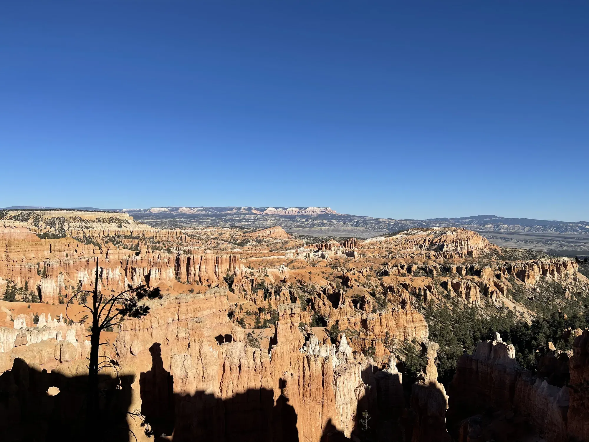
Fairyland Loop
Walk the Fairyland circuit using the connecting Rim Trail segment. Tower Bridge is a shorter destination described separately by NPS, not a way to complete the entire loop without the remaining climb.
Bryce Canyon · Photo: David & Keri New
- 8 miDistance
- 1,900 ftElevation gain
- 4–5 hrTime
- StrenuousDifficulty
The numbers, with sources
Distance: 8 miles including connecting Rim Trail segment Source
Gain: 1,900 feet of gain; inventory length differs from the rounded loop distance Source
Time: Approximately 4–5 hours Source
Difficulty: Difficulty: Strenuous (rapid elevation gain, longer length) Source
Trailhead: Start at Fairyland Point or the Tower Bridge trailhead north of Sunrise Point. There is no shuttle pickup at Fairyland Point. Source
Route type: loop Source
Built from official sources (checked Nov 3, 2026). Confirm current conditions with the park.
Recreation.gov permits, entrances & campgrounds
Recreation.gov (RIDB). Booking records date not published. NPS guidance above takes precedence. A listing doesn’t mean you need a permit or that there’s space on your dates.
Park campground options (2)
These records belong to the park’s NPS recreation area. We haven’t checked how close these are to the trail, when they open or whether sites are free; check the map and the booking page.
North Campground (UT) — Campground; RIDB reservable: yes. Season: not published in structured RIDB data. Recreation.gov (RIDB) source · Booking details
Sunset Campground (UT) — Campground; RIDB reservable: yes. Season: not published in structured RIDB data. Recreation.gov (RIDB) source · Booking details
Route, junction by junction
Selected start → Selected destination
Walk the Fairyland circuit using the connecting Rim Trail segment. Tower Bridge is a shorter destination described separately by NPS, not a way to complete the entire loop without the remaining climb. Source
No elevation profile yet:
No elevation profile yet: we haven’t verified complete measurements for this route. Source
In-depth guide
Compiled from linked sources, checked Nov 2, 2026. Each paragraph links to its source.
Is this hike for you?
The Fairyland Loop is a quiet 8 mile hike that follows the plateau rim near Boat Mesa, then drops into the canyon with long views of the Bryce Amphitheater and its hoodoos. The NPS rates it strenuous (rapid elevation gain, longer length): 8.0 miles (12.9 km), 1900 feet (579 meters) of gain, about 4-5 hours. Its accessibility survey gives a slightly different length, 7.8 mi (12.6 km) round trip, and the 8 miles includes the connecting Rim Trail segment. Source
The trail
You can start at Fairyland Point or at the Tower Bridge trailhead on the rim trail north of Sunrise Point. The NPS recommends going counter-clockwise. There’s no shuttle pickup at Fairyland Point, so you have to walk back to wherever you started to close the loop. Bring the park map and stay on the trail. Source
Getting to the trailhead
Park at Fairyland Point (oversized vehicles allowed) or at Sunrise Point (no oversized vehicles while the shuttle is running). The shuttle stops at Sunrise Point but not at Fairyland Point; private options may be available. The NPS has a page on when the lots are busiest. Source
Water and restrooms
There are no services at Fairyland Point. The General Store near Sunrise Point has accessible restrooms and water-fill stations, both seasonal. Carry enough water for the whole loop. Source
Kids, strollers and wheelchairs
This is a backcountry trail on natural terrain, and the NPS says it isn’t an accessible trail. The surface is firm native sediment. Typical grade is 9.0% with a maximum of 25.0%; typical cross slope is 5%, up to 39%. The trail is usually 49 inches (124 cm) wide and narrows to 16 inches (41 cm). The NPS gives no minimum age; with kids, think about the length and the climb. Source
Dogs, permits and fees
Pets aren’t allowed on this trail. Service animals are allowed in national parks. Source
No reservation is needed for the hike. The park entrance fee is $35.00 for a private, non-commercial vehicle (15 passenger capacity or less) and everyone in it. Source · Source 2
Before you go
The trail may be impassable in mid-winter, with snow 2-15 ft. (.7-5 m) deep. The NPS doesn’t publish an opening season. Source
When we checked, the park had closed Wall Street and the Bryce Connector Trail (Bryce Point to Peekaboo Loop Trail) after recent rains. Other trails were open, but the NPS warned that freezing nights make rockfall more likely during the day. Check the park’s current alerts before you go, and turn back early if the group is slower than expected. Source · Source 2
Elevation profile
There’s no elevation profile yet: we haven’t verified complete measurements for this route. Source
Sources & planning limits
Reviewed 2026-11-03. Check current conditions for your trip dates.
- The NPS distance and elevation figures for this loop don’t all line up, and we haven’t worked out which is right. Source
- NPS details are as of the date shown. Confirm access, services and reservations for your travel date. Source
- We don’t rate this trail for kids or mobility needs. Check the NPS accessibility details before you go. Source
- We haven’t confirmed access, the shuttle or services for your date. Check with the NPS before you rely on them. Source
- No elevation profile yet: we haven’t verified complete measurements for this route. Source
Getting there and back
Start at Fairyland Point or the Tower Bridge trailhead north of Sunrise Point. There is no shuttle pickup at Fairyland Point. Source
Return: Complete the return arrangement described for this route. We use the NPS distances and elevation labels for the full loop. The route descends among hoodoos and climbs back to the rim, so beginning with a descent does not reduce the climb required to complete the day. Source
Water
Distance: 8.0 mile (12.9 km) Approximate Time: 4-5 hours Elevation Gain: 1900 feet (579 meters) Difficulty: Strenuous (rapid elevation gain, longer length) Services: Accessible restrooms available at the General Store near Sunrise Point (seasonally). Source
Water-fill stations available at the General Store (seasonally). Source
Hazards
Season
The NPS does not publish a seasonal opening window for this route. Source
The NPS does not publish a seasonal opening window for this route. Source
Gear & rules
The NPS activity marks pets permitted: false. Source
Filling a gap in your kit? Compare these packing essentials on Amazon. Choose gear for your route, conditions and the park’s guidance.
As an Amazon Associate we earn from qualifying purchases. How this works
Questions
Which hike is this?
Walk the Fairyland circuit using the connecting Rim Trail segment. Tower Bridge is a shorter destination described separately by NPS, not a way to complete the entire loop without the remaining climb. Source
Are the published figures fully consistent?
We use the NPS distances and elevation labels for the full loop. The route descends among hoodoos and climbs back to the rim, so beginning with a descent does not reduce the climb required to complete the day. Source
Is there an elevation profile?
Elevation profile omitted: The inspected feature named Fairyland Loop is only part of the published eight-mile circuit. A complete ordered loop including its rim connection has not been verified from the export. Source
Alternatives
Camp near Fairyland Loop
Closest campgrounds by drive time to Fairyland Loop Trailhead:
- 11 min North (2.6 mi, in the park)
- 11 min Sunset (2.6 mi, in the park)
- 23 min Red Canyon (Dixie National Forest) ↗ (14.2 mi, USDA Forest Service)
- 31 min Coyote Hollow ↗ (10.8 mi, USDA Forest Service)
- 36 min Kings Creek ↗ (14.8 mi, USDA Forest Service)
Driving time with no traffic (OSRM, OpenStreetMap roads). Some park roads are shuttle-only in season. All camping near Bryce Canyon
More Bryce Canyon trail guides
- Mossy Cave Trail0.8 mi · Easy
- Queen’s Garden/Navajo Combination Loop2.9 mi · Moderate