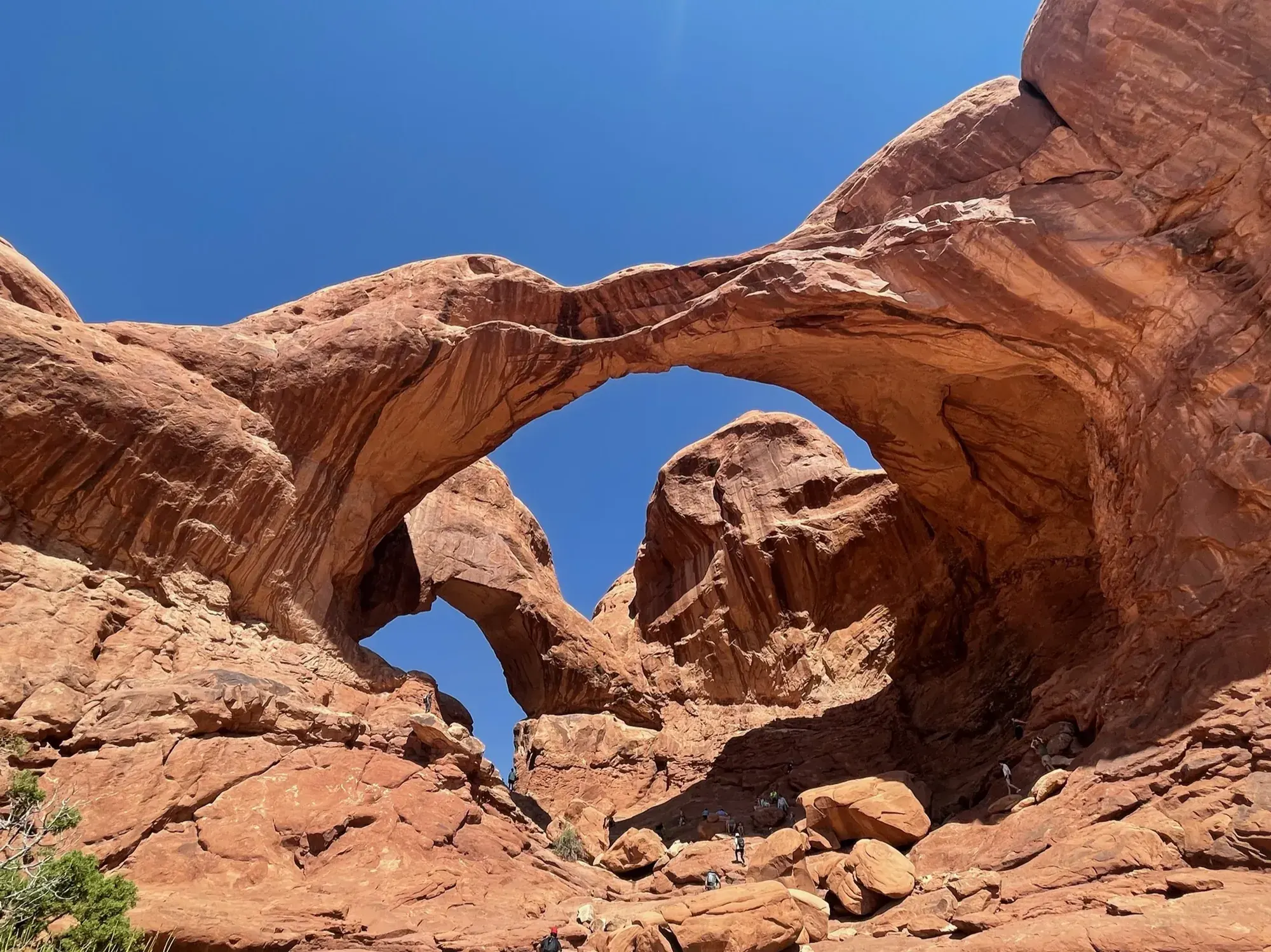
Double Arch Trail
Follow the gently sloping path from The Windows parking-loop area to the base of Double Arch, then return. Rock scrambling beneath the arches is an optional separate decision, not part of the basic path description.
Arches · Photo: David & Keri New
- 0.6 miDistance
- 30 ftElevation gain
- 15–30 minTime
- EasyDifficulty
The numbers, with sources
Distance: 0.6 mile round trip Source
Gain: 30 feet of elevation change Source
Time: 15–30 minutes for the basic approach Source
Difficulty: Difficulty : Easy Source
Trailhead: The Windows parking loop; a separate stair connector reaches the upper parking lot and Windows trailhead. Source
Route type: out-and-back Source
Built from official sources (checked Nov 3, 2026). Confirm current conditions with the park.
Recreation.gov permits, entrances & campgrounds
Recreation.gov (RIDB). Booking records date not published. NPS guidance above takes precedence. A listing doesn’t mean you need a permit or that there’s space on your dates.
Nearby campground records
Within 10 straight-line miles of the trailhead. Distances are straight-line from map coordinates, not driving distances.
- DEVILS GARDEN CAMPGROUND: approximately 6.7 miles straight line. RIDB coordinates · Mapped route source
Park campground options (1)
These records belong to the park’s NPS recreation area. We haven’t checked how close these are to the trail, when they open or whether sites are free; check the map and the booking page.
DEVILS GARDEN CAMPGROUND — Campground; RIDB reservable: yes. Season: not published in structured RIDB data. Recreation.gov (RIDB) source · Booking details
NPS reservation guidance: You can reserve campsites for nights between March 1 and October 31. Between November 1 and February 28, all sites are first-come, first served. Reservations for both group and individual sites can be made below or by calling Recreation.gov at 1-877-444-6777. The earliest you can make reservations for standard sites is 10 am eastern time, six months in advance. The latest you can make reservations is four days in advance. You can reserve group sites up to 12 months in advance. The campground has two sites for groups of 11 or more people. Juniper Basin campsite accommodates up to 55 people and is available March 1 to October 31; Canyon Wren campsite accommodates up to 35 and may be reserved year-round. No RVs or trailers are permitted in the group sites. NPS source
Route, junction by junction
Selected start → Selected destination
Follow the gently sloping path from The Windows parking-loop area to the base of Double Arch, then return. Rock scrambling beneath the arches is an optional separate decision, not part of the basic path description. Source
No elevation profile: we only draw one from a mapped route we can verify. Route source
In-depth guide
Compiled from linked sources, checked Nov 2, 2026. Each paragraph links to its source.
Is this hike for you?
Double Arch is the tallest (112 ft/34 m) and second-longest (144 ft/44 m) arch in Arches National Park: two giant spans joined at one end. You can see it from the parking loop at The Windows, and a gently sloping path leads to its base. It’s 0.6 mi (1 km) round trip with 30 ft (10 m) of elevation change, rated easy, and takes 15-30 minutes. Source
The trail
The trail is short and gentle. Some people scramble up the rock beneath the arches. If you do, plan your route carefully, because climbing up is often easier than getting back down. Source
Double Arch is in The Windows Section, one of the most scenic parts of the park, with a large concentration of arches in just over two square miles. North Window and Turret Arch are nearby, along with Garden of Eden, Elephant Butte and Parade of Elephants. Source
Getting to the trailhead
The trailhead is on The Windows parking loop. Across from it, a connector trail climbs stairs to the upper parking lot and the Windows trailhead. If you want to see more arches, park in one lot and walk between the two. Source
Before you go
The NPS doesn’t give a season for this trail. In the latest NPS alert we saw, the Delicate Arch Viewpoints were closed because of flooding and debris on the road to them, with Delicate Arch Road open to Wolfe Ranch. That’s a different part of the park, but check current alerts before you go. Source · Source 2
There’s no elevation profile yet: the NPS trail line is sampled with USGS 3DEP terrain, but we haven’t verified complete measurements for this route. Source
Kids, strollers and wheelchairs
The NPS calls this hard-packed, gently sloping trail barrier-free and says it may be accessible to wheelchairs with some assistance. It doesn’t publish a detailed accessibility survey or rate it for kids. Watch young kids if they want to scramble up the rock. Source
Dogs, permits and fees
Dogs aren’t allowed on this trail. Service animals are allowed in national parks. Source
The NPS doesn’t say whether you need a reservation for this hike. Source · Source 2
Entrance is $30.00 per private, non-commercial vehicle (15 passenger capacity or less) and everyone in it. Source
Plan your visit
Bring the park map and plan which arches you want to see. A short hike can still run long if you stop to scramble, so leave time for it. Source
Sources & planning limits
Reviewed 2026-11-03. Check current conditions for your trip dates.
- We haven’t confirmed access, transport or services for your date. Check with the NPS before you rely on them. Source
- NPS details are as of the date shown. Confirm access, services and reservations for your travel date. Source
- The NPS doesn’t rate this trail for kids. Read its accessibility notes before you go. Source
- No elevation profile yet: we haven’t verified complete measurements for this route. Source
Getting there and back
The Windows parking loop; a separate stair connector reaches the upper parking lot and Windows trailhead. Source
Return: Complete the return arrangement described for this route. NPS describes the hard-packed approach as barrier-free and potentially usable by wheelchairs with assistance. That statement applies to the approach trail and does not certify optional rock scrambling. The connector to the upper Windows parking lot has stairs, which changes the walk. Source
Water
Hazards
Hikers choosing to scramble up the rock beneath the arches should plan their route carefully, as climbing up is often easier than climbing back down. Source
Season
The NPS does not publish a seasonal opening window for this route. Source
The NPS does not publish a seasonal opening window for this route. Source
Gear & rules
The NPS does not publish pet rules for this exact route. Source
Filling a gap in your kit? Compare these packing essentials on Amazon. Choose gear for your route, conditions and the park’s guidance.
As an Amazon Associate we earn from qualifying purchases. How this works
Questions
Which hike is this?
Follow the gently sloping path from The Windows parking-loop area to the base of Double Arch, then return. Rock scrambling beneath the arches is an optional separate decision, not part of the basic path description. Source
Are the published figures fully consistent?
NPS describes the hard-packed approach as barrier-free and potentially usable by wheelchairs with assistance. That statement applies to the approach trail and does not certify optional rock scrambling. The connector to the upper Windows parking lot has stairs, which changes the walk. Source
Is there an elevation profile?
Official NPS trail geometry sampled with USGS 3DEP. Partial profile: the mapped approach is shown; the parking-loop connector is unverified. Reference comparison uses 0.30 mi one way; the traced line measures 0.25 mi. The difference is unresolved. The chart shows the mapped Double Arch approach. We haven’t checked the connector from the parking loop. Distance comparison: Half of the NPS 0.6-mile round trip, for the outward comparison. Source
Alternatives
Camp near Double Arch Trail
Closest campgrounds by drive time to Double Arch Trailhead:
- 25 min Devils Garden (11.5 mi, in the park)
- 51 min Courthouse Rock Campground ↗ (23.9 mi, Bureau of Land Management)
- 55 min Ken’s Lake Campground ↗ (27.9 mi, Bureau of Land Management)
- 1 hr 17 min North Klondike Campground ↗ (32.3 mi, Bureau of Land Management)
- 2 hr 46 min Hatch Point Campground ↗ (74.4 mi, Bureau of Land Management)
Driving time with no traffic (OSRM, OpenStreetMap roads). Some park roads are shuttle-only in season. All camping near Arches
More Arches trail guides
- Delicate Arch3 mi
- Devils Garden7.9 mi · Strenuous
- Fiery FurnaceStrenuous
- Landscape Arch Trail1.8 mi · Easy