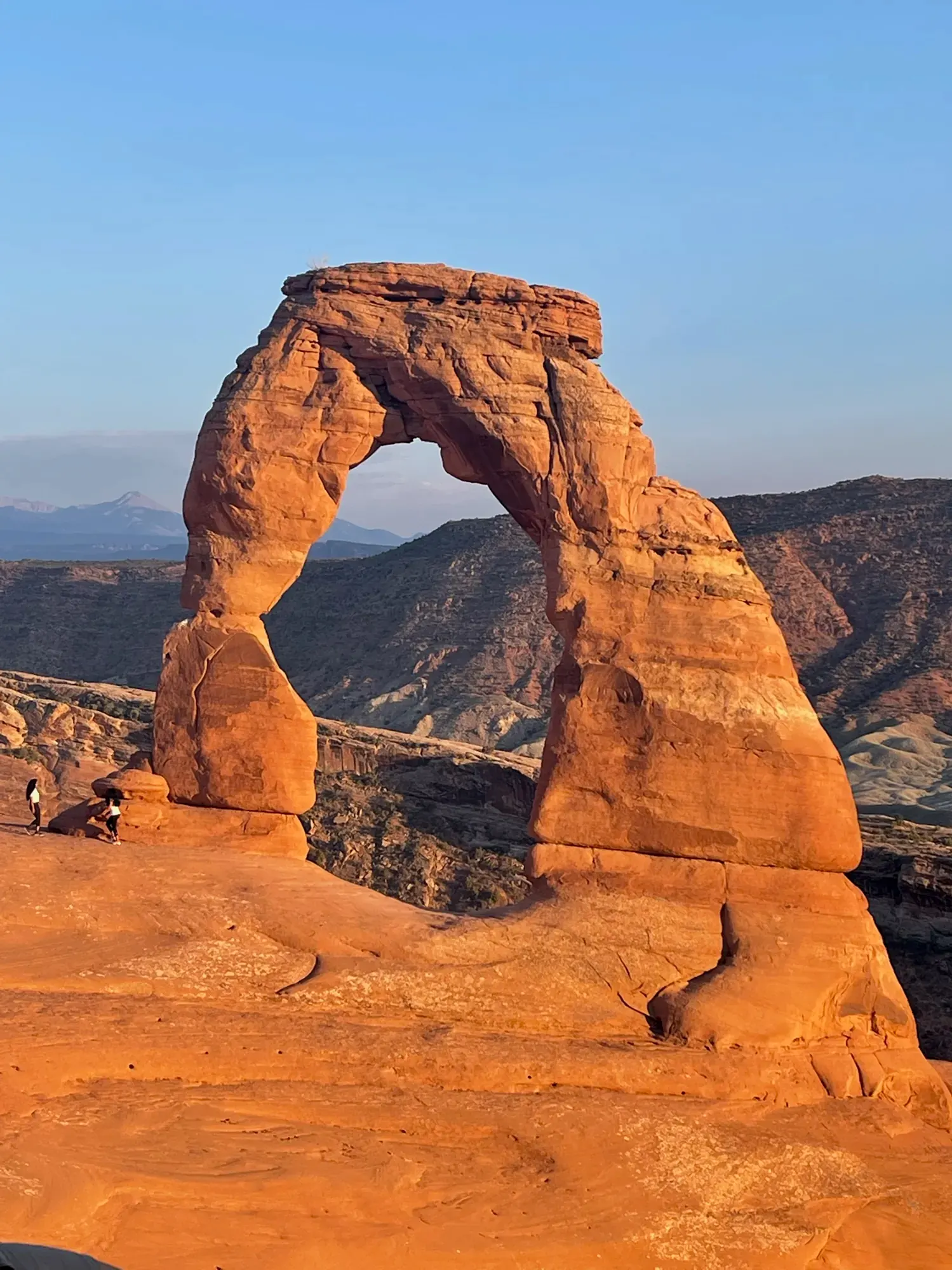
Delicate Arch
The trail from Wolfe Ranch climbs to a close view of Delicate Arch. It passes the Wolfe Ranch cabin and a Ute Indian petroglyph wall.
Arches · Photo: David & Keri New
- 3 miDistance
- 480 ftElevation gain
The numbers, with sources
Distance: 3 mi round trip. Source
Gain: 480 ft. Source
Difficulty: Steadily uphill; NPS warns that hikers often underestimate the difficulty. Source
Trailhead: Wolfe Ranch trailhead. Source
Route type: out-and-back Source
Built from official sources (checked Nov 3, 2026). Confirm current conditions with the park.
Recreation.gov permits, entrances & campgrounds
Recreation.gov (RIDB). Booking records date not published. NPS guidance above takes precedence. A listing doesn’t mean you need a permit or that there’s space on your dates.
Nearby campground records
Within 10 straight-line miles of the trailhead. Distances are straight-line from map coordinates, not driving distances.
- DEVILS GARDEN CAMPGROUND: approximately 4.7 miles straight line. RIDB coordinates · Mapped route source
Park campground options (1)
These records belong to the park’s NPS recreation area. We haven’t checked how close these are to the trail, when they open or whether sites are free; check the map and the booking page.
DEVILS GARDEN CAMPGROUND — Campground; RIDB reservable: yes. Season: not published in structured RIDB data. Recreation.gov (RIDB) source · Booking details
NPS reservation guidance: You can reserve campsites for nights between March 1 and October 31. Between November 1 and February 28, all sites are first-come, first served. Reservations for both group and individual sites can be made below or by calling Recreation.gov at 1-877-444-6777. The earliest you can make reservations for standard sites is 10 am eastern time, six months in advance. The latest you can make reservations is four days in advance. You can reserve group sites up to 12 months in advance. The campground has two sites for groups of 11 or more people. Juniper Basin campsite accommodates up to 55 people and is available March 1 to October 31; Canyon Wren campsite accommodates up to 35 and may be reserved year-round. No RVs or trailers are permitted in the group sites. NPS source
Route, junction by junction
Wolfe Ranch trailhead → Wolfe Ranch cabin and petroglyph panel
Begin at the Wolfe Ranch trailhead. NPS identifies the initial section to the historic cabin and petroglyph panel as wheelchair accessible. Beyond this initial section, the route climbs steeply up rock; the accessible start does not describe the full trail to the arch. Source
Cabin and petroglyph area → Steep slickrock slope
The trail climbs a steep slickrock slope without shade and with some exposure to heights. Watch the trail markers carefully to avoid becoming lost. Delicate Arch itself is not visible until the end of the trail, so there is no view of the arch from this climb that substitutes for reaching the destination. Source
Upper slickrock approach → Final narrow rock ledge
Just before reaching Delicate Arch, the route follows a narrow rock ledge. NPS gives this final ledge section as about 200 yards long and warns that it is often icy in winter. The trailhead page recommends shoe traction for safely crossing icy sections rather than assuming the exposed rock stays dry. Source
Distance: Final narrow ledge: about 200 yards on its own, not the distance from the trailhead. Source
Final narrow rock ledge → Delicate Arch
The arch comes into view at the end of the trail. NPS describes it as the park’s largest free-standing arch, with a light opening 46 feet high and 32 feet wide. The feature is protected: visitors must not climb or walk on arches, including when seeking a photograph. Source
No elevation profile: we only draw one from a mapped route we can verify. Route source
In-depth guide
Compiled from linked sources, checked Nov 2, 2026. Each paragraph links to its source.
Is this hike for you?
The Delicate Arch trail is a strenuous, unshaded climb up open slickrock, ending on a narrow, exposed ledge near the arch. You don’t see the arch until the very end, so there’s no halfway view to aim for. If someone in your group doesn’t like heights, a viewpoint is a fine destination on its own; decide that in the parking lot, not on the ledge. Source
We haven’t confirmed a single NPS distance for the full trail, so we don’t give one here. Source
The trail
Arches trails often cross broad rock, with cairns marking the way. On slickrock, look for the next cairn rather than a dirt path, and don’t cut across plants or fragile soil. Follow the official cairns, leave them alone and don’t build new ones. Source
The hike goes in stages: the cabin, the slickrock slope and the final ledge. Check in with your group at the start of the rock and again before the exposed part, and save enough energy and daylight to come back the same way. Source
Getting there and parking
Wolfe Ranch and the Delicate Arch Trailhead are 13.2 miles from the entrance station and visitor center, about a 30–35 minute drive. Delicate Arch Viewpoint is 14.2 miles in, with the same drive time. Add time for entrance lines and full lots. There’s no public transportation inside Arches; you get around by car, bike or commercial tour. Source
The Wolfe Ranch toilets are open year-round, but there’s no drinking water at the trailhead. Fill up in town or at the visitor center, and keep extra water in the car. Source · Source 2
In 2026 Arches didn’t require timed-entry reservations, but it could turn cars away when the park got congested. Check the entry rules for your travel dates. Devils Garden Campground and Fiery Furnace hikes need their own reservations, and getting into the park doesn’t hold you a space at Wolfe Ranch. Source
Temporary entry closures can last three to five hours. The park asks you not to wait along the highway or near the entrance sign; come back another time or go somewhere else. Have food, water, fuel and a backup plan before you join the entrance line. Source
Heat and snow
In summer, the park advises against hard exercise from 10 am to 5 pm, when the sun is strongest. Eat, and bring salty snacks to replace electrolytes. Even if you start in the cooler evening, carry plenty of water and food for the return. Source
In winter, drifting snow can hide the trail markers. Ask at the visitor center for current trail information and photos, and turn around if you lose the cairns or the footing gets sketchy. Source
On the drive, stop only in pullouts and parking areas, carry extra water in the car, and if your car breaks down, stay with it until help arrives. Source
Wolfe Ranch and the rock markings
Wolfe Ranch is more than a historic cabin. Zuni, Hopi, Ute, Paiute and other tribes have long traveled and used this landscape, with water at the center of those ties. Look at the rock markings from the trail. Source
Don’t touch, rub, scratch or trace rock markings; oils from skin damage them. Eat away from archeological sites, since crumbs draw rodents that nest there. Leave artifacts where you find them, including pottery fragments, stone chips and old cans and bottles. If you see fresh damage or someone disturbing a site, tell a ranger. Source
Wheelchairs and easier options
Lower Delicate Arch Viewpoint is the easier option. The upper viewpoint has rock steps and stairs and a maximum grade of 41 percent, so don’t assume a viewpoint means a level walk. Source
The Arches Visitor Center lends a nonmotorized all-terrain wheelchair, first come, first served, with no reservations. Someone has to push it, both of you sign waivers, one of you shows ID and proof of insurance, and it has to be back before the visitor center closes that day. The park recommends it for Lower Delicate Arch Viewpoint. It lists the full Delicate Arch Trail among routes with obstacles that may need a fit operator or several helpers, so talk to a ranger first. Source
If Wolfe Ranch is full, two short trails nearby are worth a look. Double Arch is 0.6 mile round trip on a hard surface that turns sandy near the end, with no listed obstructions. Balanced Rock is 0.3 mile round trip; it starts paved but includes bedrock and rock steps. Stay on the trail and don’t climb the rock. Source
Before you go
Check entry and road conditions, decide between the full trail and a viewpoint, pack for it and agree on how you’re getting back. If you get lost, stay where you are and wait for help. Source
We haven’t confirmed the elevation figures for this trail, so there’s no elevation gain or profile here. Source · Source 2 · Source 3
Check the NPS pages for your trip dates; access, transport and services change. Source
Sources & planning limits
Reviewed 2026-11-03. Check current conditions for your trip dates.
- We haven’t confirmed access, transport or services for your trip date. Check with the NPS and any transport provider. Source
- We haven’t confirmed this. Check the linked NPS page for your trip. Source
- We haven’t been able to confirm one measured distance for this trail. Each NPS number here goes with the start and end it names. Source
- We haven’t confirmed the elevation figures for this trail, so we don’t give a total climb or rate it for mobility. Source
Getting there and back
Park at Wolfe Ranch. If full, additional parking is at Delicate Arch Viewpoint; walking along the road adds distance and makes a 5 mi round trip. Source
Return: Retrace the approach to Wolfe Ranch. NPS advises maintaining a sense of direction and ensuring that the route can be retraced. Sunset visitors should carry a flashlight or headlamp for each person as directed by the trailhead page. If starting from overflow parking at Delicate Arch Viewpoint, the separate road walk also has to be included in the return plan. Source
Water
There is no drinking water at the Wolfe Ranch trailhead. The trailhead page says to bring at least two quarts (two liters) per person. Source
The park safety page recommends at least 2–3 liters per person for front-country hikes and four liters or more for backcountry trips. It identifies water at the visitor center and Devils Garden Campground, advises drinking when thirsty, and says that being halfway through the water supply means being halfway through the hike. Source
Do not drink from desert potholes or ephemeral pools. These shallow sandstone basins support organisms dependent on their water. NPS also asks visitors not to swim or bathe in the pools or walk through dry ones. Source
Hazards
Heat and lack of shade
The trailhead description warns of a steep, unshaded slickrock climb and says to avoid midday summer heat. The broader safety page advises planning activities in the cooler early morning or late evening. The route requires assessing the weather and the group’s health and fitness before committing to the climb. Source
Exposed ledge and ice
The final narrow rock ledge is about 200 yards long and is often icy in winter. NPS recommends carrying traction devices for shoes. Exposure to heights is part of the route description; the short length of the ledge is not a statement that it is suitable for every visitor. Source
Slippery sandstone
Sandstone can be slippery when wet or covered in sand. NPS says to make sure of the footing before moving and to avoid climbing arches or balanced-rock features. Footwear should provide good tread and traction on uneven ground. Source
Route finding and delayed rescue
Cellular coverage is spotty, and some park trails can be unmarked. Download maps before leaving coverage and bring a physical map and compass as backup. NPS warns that immediate rescue help may be unavailable, so share an itinerary with someone at home before leaving. Source
Summer storms and flash floods
Summer monsoons can bring heavy rain, floods, lightning, wind and hail. Flash floods can occur even in sunshine; a surge, color change, debris increase or rushing-water sound means moving to higher ground. Do not try to cross a flooded wash. Source
Thunderstorms
If thunder is heard, NPS says to seek shelter immediately and wait until thunder has not been heard for at least 30 minutes before proceeding. The preferred shelter is a vehicle or building. Avoid trees and tall rock outcrops, which are more exposed to lightning. Source
Season
NPS cautions about summer heat and winter ice; consider weather and personal health and fitness before starting. Source
Summer heat and winter ice are the trail-specific seasonal concerns identified on the Delicate Arch planning page. NPS says to consider both the conditions and personal health and fitness before beginning; rangers frequently rescue visitors who underestimate the difficulty. Source
The safety page identifies July and August as the hottest months, often exceeding 100°F. Summer monsoons can change conditions quickly with heavy rain, lightning, hail and wind. Plan the activity for the cooler parts of the day and check the forecast and alerts before starting. Source
In winter, roads may close for snowplowing and drifting snow may cover trail markers. NPS recommends traction aids and trekking poles and directs visitors to the visitor center for current trail information and photographs. Cold weather does not remove the need to drink water. Source
Gear & rules
Do not walk or climb on arches. Source
Filling a gap in your kit? Compare these packing essentials on Amazon. Choose gear for your route, conditions and the park’s guidance.
As an Amazon Associate we earn from qualifying purchases. How this works
Bring at least two quarts of water per person. NPS says to avoid shoes with open toes, high heels or slick soles. Each sunset visitor should carry a flashlight or headlamp; in winter, carry shoe traction for icy sections. Source
Carry footwear with good tread, a sturdy pack for water and supplies, and sun protection. Dress in layers for changing conditions, especially in fall, winter and spring, and bring rain gear. Download offline maps and carry a paper map and compass in case the phone battery fails. Source
Dogs are prohibited on the trail. Service animals are allowed in national parks. The initial wheelchair-accessible section to the cabin and panel should not be confused with an accessible route all the way to Delicate Arch. Source
Climbing, scrambling, walking or standing on, or rappelling off any arch is prohibited. Do not scratch, carve, chalk or otherwise mark the rock. Stay on trails, rock or sandy washes to protect biological soil crust. Source
Pace
The NPS trailhead page publishes 2–3 hours for the complete three-mile round trip. It does not assign separate times to the cabin section, slickrock climb, ledge or final approach. This is official whole-trip guidance, not a basis for estimating speed on individual stretches. Source
Questions
Can the arch be seen without taking the strenuous trail?
Yes. Lower Delicate Arch Viewpoint has a level 100-yard walk to a view from about one mile away. Nearby Upper Viewpoint is a half-mile walk with stairs and a slightly less obstructed view. These are alternatives to the up-close trail, not the same destination. Source
Is the whole Delicate Arch route wheelchair accessible?
No. The first section to Wolfe Ranch cabin and the petroglyph panel is identified as wheelchair accessible; beyond it, the trail climbs steeply up rock. The mobility page also lists steep climbs, rock steps, and a ledge with a drop-off for the full trail. Source
What happens if Wolfe Ranch parking is full?
NPS identifies additional parking at Delicate Arch Viewpoint. Reaching the Wolfe Ranch trailhead from that lot requires a one-mile road walk each way, increasing the total round trip to five miles. Do not plan from the three-mile trail distance if using that overflow location. Source
Can a sunset visit be quiet and uncrowded?
NPS says sunset is particularly busy and sometimes hundreds of people are at Delicate Arch then. The trail can be busy through much of the year. The trailhead page also tells sunset visitors to carry a headlamp or flashlight for each person. Source
Is there water or a toilet at the trailhead?
The NPS place page lists a vault/composting toilet among the trailhead amenities and explicitly says there is no drinking water. Arrive carrying water; the page recommends at least two quarts per person. Source
Why are different elevation and distance figures shown?
An older NPS planning page says three miles round trip and 480 feet of climbing. The trailhead page says three miles and 538 feet of elevation change, and the NPS mobility survey lists 3.2 miles. The NPS pages don’t agree, so we show each figure with its source instead of picking one. Source
Alternatives
Lower Delicate Arch Viewpoint: Walk a level 100 yards to see the arch from one mile away; the Upper Viewpoint is a 0.5 mi walk with stairs. Source
Camp near Delicate Arch
Closest campgrounds by drive time to Delicate Arch Viewpoint Trailhead:
- 22 min Devils Garden (8.9 mi, in the park)
- 56 min Courthouse Rock Campground ↗ (26.1 mi, Bureau of Land Management)
- 1 hr Ken’s Lake Campground ↗ (30 mi, Bureau of Land Management)
- 1 hr 22 min North Klondike Campground ↗ (34.5 mi, Bureau of Land Management)
- 2 hr 50 min Hatch Point Campground ↗ (76.5 mi, Bureau of Land Management)
Driving time with no traffic (OSRM, OpenStreetMap roads). Some park roads are shuttle-only in season. All camping near Arches
More Arches trail guides
- Devils Garden7.9 mi · Strenuous
- Double Arch Trail0.6 mi · Easy
- Fiery FurnaceStrenuous
- Landscape Arch Trail1.8 mi · Easy