
CongareeItinerary
Congaree itinerary
A free one-day Congaree itinerary with the Boardwalk Loop, a shorter flood backup and an optional second day for a planned Cedar Creek paddle.
By David & Keri New, who have visited 63 of the 64 U.S. national parks
Congaree · Photo: David & Keri New
Choose your days
One day covers the main forest walks. Add Day 2 only for a planned paddle when water levels and access allow. Use the shorter one-day backup if flooding changes the visit.
Check flood alerts, boardwalk access and creek conditions before each day. Rain upstream can change water levels even when local weather looks clear. Check NPS flooding and trail conditions
NPS paddling notice: Trees down across Cedar Creek between Bannister’s Bridge and South Cedar Creek may require significant portages depending on water levels & paddlers should plan accordingly. All paddlers should have necessary equipment, including the 10 Essentials. Confirm the route with your outfitter before leaving. NPS update · Checked .
Choose an NPS-listed paddling outfitter
David and Keri’s favorite: Boardwalk Loop.
Times are suggested local starts. Closure flags update from the NPS alert feed when available. Check conditions again before your visit. Check park alerts
Open the free one-page planner
1 day
Make time for Boardwalk Loop
Add your dates and save a copy.
Day 1 · The Boardwalk Loop and an optional longer forest walk
Check flooding and trail closures before driving. Use only open, dry routes. If the boardwalk or the longer trail is flooded, switch to the shorter flood backup. Postpone if roads, the visitor center or all suitable trails are inaccessible. Access source
2 stops in order; not on the map: Weston Lake Trail (not one fixed place, or no reliable position). Positions from NPS visitor center listing, OpenStreetMap; map data loads from OpenStreetMap when you tap. Not for navigation.
-
Harry Hampton Visitor Center
Ask about water levels, boardwalk access and trail conditions. Pick up the trail map and bring water and insect protection.
Facts for Harry Hampton Visitor Center
Open 9:00 a.m. to 5:00 p.m. daily. Closed New Year’s Day, Washington’s Birthday, Columbus Day, Thanksgiving Day, and Christmas Day. Hours may be affected by events, such as the annual Firefly Viewing Event in May, or by resource management activity. Please check park alerts prior to your visit. 1
- Hours
- Daily 9:00AM - 5:00PM (standard week); seasonal hours differ, see the NPS page 1
- At the center
- Bus/Shuttle Stop, Food/Drink - Snacks, Gifts/Souvenirs/Books, Historical/Interpretive Information/Exhibits, Information, Information - Maps Available 1
- Passport stamp
- Visitor Information Kiosk located in the Visitor Center Breezeway. 1
- Access features
- Accessible Rooms, Accessible Sites, Assistive Listening Systems, Automated Entrance, Braille, Captioned Media 1
-
Boardwalk Loop
Make this your main forest walk. Follow the posted route and turn back at flooding or barriers. Check access again before adding a longer hike.
Facts for Boardwalk Loop
A 2.6-mile forest loop beginning at Harry Hampton Visitor Center, with an elevated descent from the bluff into bottomland hardwood habitat. 1
- Distance
- 2.6 miles round trip in the official trail information page. 1
- Elevation
- No numerical cumulative gain is supplied in the evidence used here. 1
- Time
- No numerical duration is supplied in the evidence used here. 1
- Difficulty
- Easy in the official trail information page; conditions and the party’s needs still determine the trip. 1
- Route
- loop 2
- Trailhead
- Harry Hampton Visitor Center. 2
- Where
- Harry Hampton Visitor Center 3
- Walking
- 2.6 mi accessible boardwalk 3
Source 1 (nps.gov) · Source 2 (nps.gov) · Source 3 (nps.gov) · Full trail guide
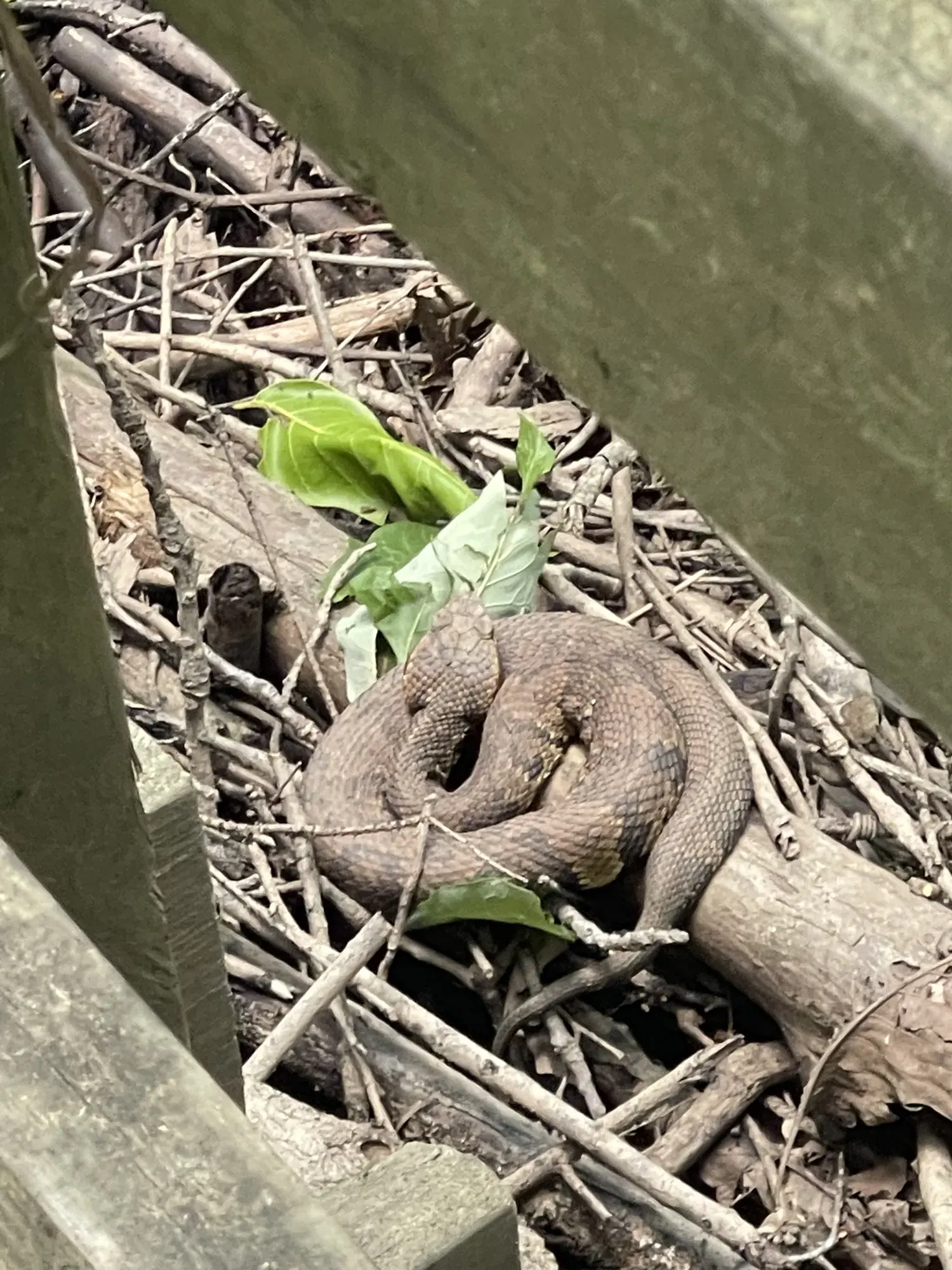
A snake curled up among the sticks beside the boardwalk. · May 2022 · Our photo -
Weston Lake Trail
Extend the walk only if the route is open, dry and within your group’s pace. Review its connections on the NPS trail map rather than adding the two loop distances together.
Facts for Weston Lake Trail
See an oxbow lake and cypress-tupelo forest beside Cedar Creek. 1
Optional day 2 · Cedar Creek paddle
Make time for Cedar Creek paddle
Add this after the 1-day plan.
Add your dates and save a copy.
Day 2 · An optional Cedar Creek paddling day
Check the NPS water-level guidance and linked gauges, then confirm conditions with your outfitter. High water and downed trees can make a trip unsuitable. If paddling is canceled, drop Day 2 and use the one-day plan or the shorter flood backup. Access source
-
South Cedar Creek Landing
Plan a guided trip from this landing and confirm the launch with your outfitter. Bring the required equipment and allow time for the safety briefing. If your booking uses another launch, follow its directions.
-
Cedar Creek paddle
Use a short trip matched to water levels and your group. For an independent trip, NPS describes an out-and-back from South Cedar Creek Landing. Set your turnaround before launching and return to the same landing.
Flood backup · Shorter one-day visit
Add your dates and save a copy.
Day 1 · Visitor center and a dry trail, only if accessible
This backup opens a one-day trip and drops the optional paddle. Check that the approach roads and visitor center are accessible. If flooding or closures prevent a safe visit, postpone. Stay off submerged paths and keep clear of closure barriers. Access source
2 stops in order. Positions from NPS visitor center listing, OpenStreetMap; map data loads from OpenStreetMap when you tap. Not for navigation.
-
Harry Hampton Visitor Center
Use the exhibits and ask staff which routes are currently safe. Keep this a short visit if the floodplain is inaccessible.
Facts for Harry Hampton Visitor Center
Open 9:00 a.m. to 5:00 p.m. daily. Closed New Year’s Day, Washington’s Birthday, Columbus Day, Thanksgiving Day, and Christmas Day. Hours may be affected by events, such as the annual Firefly Viewing Event in May, or by resource management activity. Please check park alerts prior to your visit. 1
- Hours
- Daily 9:00AM - 5:00PM (standard week); seasonal hours differ, see the NPS page 1
- At the center
- Bus/Shuttle Stop, Food/Drink - Snacks, Gifts/Souvenirs/Books, Historical/Interpretive Information/Exhibits, Information, Information - Maps Available 1
- Passport stamp
- Visitor Information Kiosk located in the Visitor Center Breezeway. 1
- Access features
- Accessible Rooms, Accessible Sites, Assistive Listening Systems, Automated Entrance, Braille, Captioned Media 1
-
Bluff Trail
Consider this higher-ground walk only if open and dry. Turn back at water or barriers. If there is no suitable trail, finish at the visitor center or postpone the trip.
Good to know
For your days in Congaree
Wildlife and where to look (6)
- River otters. Cedar Creek. See the creek from the Weston Lake Trail. nps.gov
- Wild turkey. Sloughs along Oakridge Trail. Look along low-lying sloughs. nps.gov
- Turtles. Cedar Creek. Watch from your canoe or kayak. nps.gov
- Deer. Low-lying sloughs along Oakridge Trail. NPS lists deer among wildlife seen here. The current trail rating is difficult; check flood alerts. nps.gov
- Wading birds. Cedar Creek beside Weston Lake Trail. NPS says they are regularly observed from this trail. nps.gov
- Alligators. Cedar Creek. NPS describes occasional sightings during paddling; sightings are not guaranteed. nps.gov
Night sky and light (2)
Longer drives between areas (2)
- Harry Hampton Visitor Center to South Cedar Creek Canoe Landing: about 5 minutes. Published by Palmetto Outdoor; meet at 1716 S Cedar Creek Road for its tour. palmettooutdoor.com
- Road access to Congaree River within the park: . No vehicle access to the river from inside the park. Creek launches are at Bannister’s Bridge and South Cedar Creek; river access is outside the park at Route 601 or Columbia. Driving time not published. nps.gov
Add a guided tour to your Congaree days
Affiliate link: we may earn a commission, at no extra cost to you. How this works
Before you go
- Congaree permits and reservations: lotteries, campground and lodging booking windows.
- Best time to visit Congaree: crowds, weather and seasonal access by month.
- Plan Congaree in the trip planner: your dates, booking deadlines and a conditions check before you leave.
- Is Congaree open today? Live NPS alerts and closures.
Plans checked against official NPS pages Nov 10, 2026.