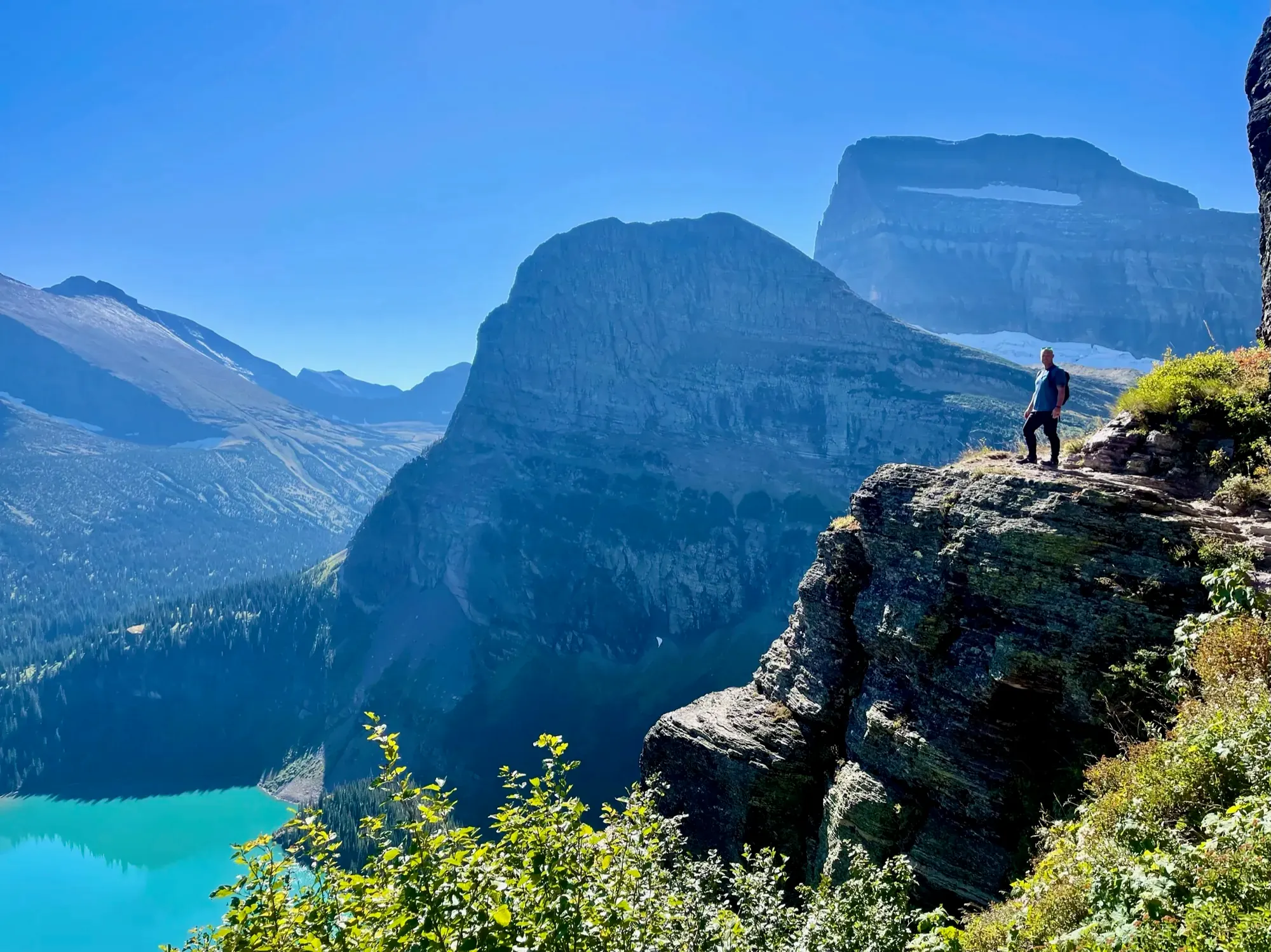
Highline Trail to Granite Park Chalet
The Highline Trail begins at the Continental Divide sign at Logan Pass and reaches Granite Park Chalet. NPS identifies glacier-viewing opportunities northwest of Haystack Butte along this trail.
Glacier · Photo: David & Keri New
- 7.6 mi one wayDistance
- 800 ftElevation gain
- StrenuousDifficulty
The numbers, with sources
Distance: 7.6 miles one way to Granite Park Chalet Source
Gain: 800 feet to Granite Park Chalet Source
Trailhead: Continental Divide sign at Logan Pass Source
Route type: point-to-point Source
Built from official sources (checked Nov 3, 2026). Confirm current conditions with the park.
Recreation.gov permits, entrances & campgrounds
Recreation.gov (RIDB). Booking records date not published. NPS guidance above takes precedence. A listing doesn’t mean you need a permit or that there’s space on your dates.
Nearby campground records
Within 10 straight-line miles of the trailhead. Distances are straight-line from map coordinates, not driving distances.
- Avalanche Campground: approximately 4.8 miles straight line. RIDB coordinates · Mapped route source
- Sprague Creek Campground: approximately 9.8 miles straight line. RIDB coordinates · Mapped route source
- MANY GLACIER CAMPGROUND: approximately 7.2 miles straight line. RIDB coordinates · Mapped route source
Park campground options (9)
These records belong to the park’s NPS recreation area. We haven’t checked how close these are to the trail, when they open or whether sites are free; check the map and the booking page.
APGAR GROUP SITES — Campground; RIDB reservable: yes. Season: not published in structured RIDB data. Recreation.gov (RIDB) source · Booking details
Apgar Campground — Campground; RIDB reservable: yes. Season: not published in structured RIDB data. Recreation.gov (RIDB) source · Booking details
NPS reservation guidance: Reservations are required throughout the spring, summer, and fall at Apgar Campground. A reservation is not required during the winter months. Reservations must be made through Recreation.gov. Five group sites are available for parties of 9-24 people. Reservations are also required for group campsites. NPS source
FISH CREEK CAMPGROUND — Campground; RIDB reservable: yes. Season: not published in structured RIDB data. Recreation.gov (RIDB) source · Booking details
NPS reservation guidance: Campsites become reservable on a rolling basis, 6 months in advance from the date you want to book your stay. Reservations must be made through Recreation.gov and must be made in advance. A certain number of sites will be reservable up to 4 days before the desired date. NPS source
Avalanche Campground — Campground; RIDB reservable: yes. Season: not published in structured RIDB data. Recreation.gov (RIDB) source · Booking details
NPS reservation guidance: Campsites become reservable on a rolling basis, 6 months in advance from the date you want to book your stay. A certain number of sites will be reservable up to 4 days before the desired date. NPS source
Rising Sun Campground — Campground; RIDB reservable: yes. Season: not published in structured RIDB data. Recreation.gov (RIDB) source · Booking details
NPS reservation guidance: Rising Sun Campground requires a reservation to book a site. Reservations have a 0-day booking window, meaning they need to be reserved the day of your desired stay. Reservations can only be made on Recreation.gov. Cell service is limited within the park boundary. It is recommended to make a Rising Sun Campground reservation before coming to the park or at St. Mary and Apgar Visitor Centers, where public wifi is available. NPS source
Two Medicine Campground — Campground; RIDB reservable: yes. Season: not published in structured RIDB data. Recreation.gov (RIDB) source · Booking details
NPS reservation guidance: Campsites become reservable on a rolling basis, 6 months in advance from the date you want to book your stay. A certain number of sites will be reservable up to 4 days before the desired date. Two Medicine Campground will be closed in 2026 due to construction. NPS source
Sprague Creek Campground — Campground; RIDB reservable: yes. Season: not published in structured RIDB data. Recreation.gov (RIDB) source · Booking details
NPS reservation guidance: Reservations are required to camp at Sprague Creek Campground. Campsites become reservable on a rolling basis, 6 months in advance from the date you want to book your stay. Reservations must be made through Recreation.gov. A certain number of sites will be reservable up to 4 days before the desired date. NPS source
MANY GLACIER CAMPGROUND — Campground; RIDB reservable: yes. Season: not published in structured RIDB data. Recreation.gov (RIDB) source · Booking details
NPS reservation guidance: Campsites become reservable on a rolling basis, 6 months in advance from the date you want to book your stay. A certain number of sites will be reservable up to 4 days before the desired date. NPS source
ST. MARY CAMPGROUND — Campground; RIDB reservable: yes. Season: not published in structured RIDB data. Recreation.gov (RIDB) source · Booking details
NPS reservation guidance: Campground sites can be reserved April 18 through October 31, 2026. Reservations are NOT required during the winter months. Reservations must be made through Recreation.gov. Individual campsites may be reserved up to 6 months in advance. The two group sites can be reserved up to six months in advance. NPS source
Route, junction by junction
Logan Pass → glacier-viewing area past Haystack Butte
NPS calls the Highline a very challenging 4 miles one way from Logan Pass to views of Vulture and Two Ocean glaciers. Start looking northwest after passing Haystack Butte; this is a viewing-area reference, not a surveyed junction mileage. Source
Haystack area → Granite Park Chalet
Continue on the Highline toward Granite Park Chalet. NPS lists 7.6 miles one way for the complete Logan Pass approach, not for this final leg. Source
Granite Park Chalet → The Loop or planned return
The NPS table lists 4.2 miles one way between The Loop and the chalet. Ending at The Loop strings different legs together, and the glacier-viewing page calls that point-to-point hike about 12 strenuous miles. Arrange the return transport before committing to that different trailhead. Source
No elevation profile: we only draw one from a mapped route we can verify. Route source
In-depth guide
Compiled from linked sources, checked Nov 3, 2026. Each paragraph links to its source.
Decisions & preparation
Leg distances appear only where the NPS publishes them; we don’t split the total into made-up legs. Source
Turnaround & return planning
The glacier views past Haystack Butte make a shorter goal. Turn back before the group runs low on energy, water or daylight. Planning basis
Parking & transport timing
From July 1–September 7, 2026, private parking at Logan Pass was limited to three hours, enforced 24 hours a day. Longer Highline day hikes needed the ticketed shuttle. The time limit and shuttle both ended after Labor Day. The NPS doesn’t say when the lot fills. Source
The 2026 Logan Pass shuttle ran July 1–September 7. Tickets gave a boarding place and time at Apgar Visitor Center, Lake McDonald Lodge, St. Mary Visitor Center or Rising Sun Picnic Area, and riders were asked to arrive at least 30 minutes early. The last departures from Logan Pass were about 7:30 p.m. westbound and 8 p.m. eastbound, and weather, road conditions or wildlife could delay them. There’s no 2027 schedule yet. Shuttle source
What to bring by season
Pack the Ten Essentials: navigation, sun protection, extra clothing, a light, first aid, fire supplies where allowed, repair tools, extra food, water and emergency shelter. Tell someone your plan. Source
In warm weather bring sun protection, plenty of water and extra food. In cold or wet weather add warm layers and rain gear. Source
In May–June, Glacier’s high country can have snow, deep cold water crossings and route-finding. In July, melting snow keeps changing conditions up high; the NPS says snow-drift blasting and trail work are usually done by the end of July. Source
August is usually the easiest month up high, with snow and water hazards mostly gone, though thunderstorms can bring water hazards back. In September–October heavy snow gets more likely, and you may need a map and compass. These are parkwide patterns. Source
The three-hour parking limit and ticketed shuttle ended after Labor Day in 2026. The NPS hasn’t posted a 2027 schedule. Source
Children & mobility
Hypothermia can happen above freezing, and being tired makes it more likely. Bring a rain layer and a warm wool hat, skip cotton like jeans and T-shirts, and keep a layer handy for stops. Source
Is this hike for you?
The Highline runs from Logan Pass to Granite Park Chalet. You can also reach the chalet by a separate trail from The Loop, so decide where you’ll finish and how you’ll get back to your car before you start. Each approach is its own long walk. Source
Glacier asks hikers to stay together and be ready to look after themselves, since help can be hours or days away. Go at a pace everyone can keep, and make it easy for anyone to ask for a break. Source
Getting to Logan Pass
Between Avalanche Creek and Rising Sun, vehicles or combinations longer than 21 feet (including bumpers) or wider than 8 feet (including mirrors) aren’t allowed. Vehicles over 10 feet tall may have trouble with rock overhangs westbound from Logan Pass toward The Loop. Measure a rental camper before you go. Source
The road over Logan Pass has no set opening date. Snow, plowing, avalanches and storms all affect it, and weather can close sections again. Check road status for your dates, then check trail conditions separately, since an open road doesn’t mean a snow-free trail. Parking and shuttle arrangements change by season, so check them too and have a backup plan if the lot is full. Source · Source 2
Water, food and fuel
Giardia can be in Glacier’s lakes and streams, even clear ones. Carry treated water, and if you’ll drink from streams, bring an approved filter or boil the water for at least 1 minute. Source · Source 2
There’s no gasoline in the park. In summer you can get food and lodging at Rising Sun, Lake McDonald Lodge and Apgar Village; check their dates, especially in fall. Fill up before the hike and keep enough fuel for the drive afterward. Source
Bears and other wildlife
Stay at least 100 yards from bears and wolves and 25 yards from other wildlife; Glacier prohibits approaching or viewing inside those distances. If an animal changes its behavior because of you, back off. On a narrow trail, wait instead of edging past, and leave the animal a clear way out. Source
Call out and clap now and then so bears know you’re coming; bear bells don’t do the job. Be extra alert by noisy streams, in thick brush, walking into the wind and at blind corners. Never leave food, garbage or your daypack unattended, and remember sunscreen and toiletries count as scented items. Source
Carry bear spray where you can reach it and know how to use it. Spray it at an oncoming bear only; never spray it on clothes or gear, which may attract bears. Wind, rain, temperature extremes and shelf life all affect how well it works. Source
Weather, cold and footing
Hypothermia can happen above freezing, and being tired makes it more likely. Bring a rain layer and a warm wool hat, skip cotton like jeans and T-shirts, and change out of sweaty clothes. Watch each other for uncontrolled shivering, fumbling hands, stumbling and slurred speech. If you see them, get the person into shelter and dry clothes, and get help if it’s severe. Source
Stay on the trail and respect guardrails; stepping off onto steep slopes can end in a fall. Snow bridges can hide holes and collapse under you. Read the trail reports before you go and turn back if the next section is beyond your group’s skills. Source
Shorter options nearby
On the east side, Sunrift Gorge is a 200-foot walk with 40 feet of gain from the Sunrift Gorge Pullout. Baring Falls starts at the same pullout and is 0.3 mile one way with 250 feet of elevation loss, which you climb back up on the return. Source
Trail of the Cedars and Running Eagle Falls are wheelchair-accessible nature trails, if a long alpine hike doesn’t suit your group. Each has its own trailhead and conditions. Source
Sources & planning limits
Reviewed 2026-11-03. Check current conditions for your trip dates.
- We haven’t confirmed access, transport or services for any given date. Check with the NPS and the shuttle before you rely on them. Source
Getting there and back
During July 1–September 7, 2026, private parking at Logan Pass was limited to three hours, enforced 24 hours daily. Longer Highline day hikes required the ticketed shuttle; time limits and shuttle service did not continue past Labor Day. Source
Shuttle: The 2026 Logan Pass shuttle ran July 1–September 7. Tickets specified a boarding place and time at Apgar Visitor Center, Lake McDonald Lodge, St. Mary Visitor Center, or Rising Sun Picnic Area. Riders were asked to arrive at least 30 minutes early for verification. Final Logan Pass departures were 7:30 p.m. westbound and 8 p.m. eastbound; listed times were approximate and could be delayed by weather, road conditions, or wildlife. These are ended 2026 operations, not a published 2027 timetable. Source
Return: NPS identifies The Loop as an exit used by many Highline hikers. During the July 1–September 7, 2026 shuttle season, only ticketed passengers with verified wristbands could board there. West-side riders returned toward Apgar; east-side riders could travel uphill to Logan Pass and transfer. The last listed uphill Loop pickup was 7 p.m.; NPS warns against relying on the final departure. That service has ended as of November 2, 2026. Source
Water
Bring plenty of water; surface water may be unsafe to drink. Route-specific toilet information is not published on this page. Source
Bring plenty of water for the trail. NPS warns that park surface water may be unsafe to drink; the presence of streams doesn’t confirm a potable supply. Source
Granite Park Chalet has no running water. Its operator lists carried water, bottled water purchased at the chalet, and a nearby stream as options. The stream is a quarter-mile away on a rocky, rugged trail; the FAQ says native water must be filtered with a one-micron filter and then boiled, or made safe with chemical treatment. Source
The Loop has restrooms but no drinking water. Carry enough to cover a wait for transport as well as the hiking portion of the itinerary. Source
Hazards
Snow-covered Highline
The chalet operator describes the Highline as extremely dangerous when snow-covered. Do not attempt it when closed, and do not use any park trail posted closed. Opening depends on spring snow conditions. Source
Snowfields and snow bridges
The NPS snow-hazard glossary describes steep, sometimes icy snowfields and potentially dangerous snow bridges. It strongly advises an ice axe and the skills to self-arrest; crampons may help. These are general condition definitions, not a claim that such hazards were observed on this route on November 2. Source
Group separation and rescue
Hike together as a group. NPS says separated parties account for more than 75 percent of its search-and-rescue incidents. Expect no cell coverage, be ready to care for yourself, and recognize that help may be hours or days away. Source
Wildlife and changing weather
Carry bear spray and know its use. Pack rain gear and warm layers because weather can change quickly. Visit a ranger station or check online for current trail and weather conditions before starting. Source
Season
Higher-elevation trails over passes and on the Continental Divide are typically snow free by late July; check trail status before travel. Source
The operator says the Highline typically does not open until after the first week in July. Actual opening depends on weather and snow conditions in that particular year; check official trail status for an early-season trip. Source
General Glacier guidance for May–June includes high-elevation snow, deep and cold water crossings, and route-finding needs. During July, melting snow creates changing high-elevation hazards; NPS says snow-drift blasting and trail treading are usually complete by the end of July. Source
August is described as accessible high country, generally with snow and water hazards gone, although thunderstorms can bring water hazards back. In September–October, significant snow becomes more likely and lingering snow can require map-and-compass navigation. These are parkwide seasonal generalizations. Source
The three-hour Logan Pass parking limit and ticketed shuttle ended after Labor Day in 2026. The opened page does not provide a 2027 replacement schedule. Source
Gear & rules
Pack out everything brought in. Source
Overnight backcountry camping requires a wilderness camping permit. Source
Filling a gap in your kit? Compare these packing essentials on Amazon. Choose gear for your route, conditions and the park’s guidance.
As an Amazon Associate we earn from qualifying purchases. How this works
Wear sturdy footwear; bring sun protection, a hat, snacks or lunch, insect repellent as needed, rain gear, and warm layers. Tell someone the precise route, return time, vehicle location, license number, and what you will wear. Source
The chalet operator prohibits pets in the backcountry and bikes or other vehicles on these trails. Horses are specifically prohibited on the Highline between Logan Pass and Granite Park Chalet. Source
Pack out what you bring. Overnight backcountry camping requires a wilderness camping permit obtained through the park; this is separate from arranging a chalet stay or day-use transport. Source
On park shuttles, secure bear spray against accidental discharge. Smoking, pets, and open alcohol containers are prohibited. The 2026 Logan Pass service supported same-day visits and was not intended for overnight trips. Source
Pace
The official chalet operator gives about 5–6 hours for the 7.6-mile Highline from Logan Pass to the chalet. This is the approach time only; it does not include a return hike, descent to The Loop, or shuttle waits. No official times for the individual stretches above were located. Source
Questions
Is the Highline only 7.6 miles?
That is the NPS one-way distance from Logan Pass to Granite Park Chalet. The table separately lists 4.2 miles from The Loop to the chalet, so an itinerary using both trails has an additional return leg. Source
Can a visitor start by boarding at The Loop?
The 2026 page calls The Loop a shuttle stop rather than a boarding location. Riders first had to verify tickets at their assigned departure location and obtain a wristband. The 2026 service has ended. Source
Can drinking water be obtained at the chalet?
The operator lists bottled water for purchase, carried water, or a nearby stream requiring treatment. It also states that the chalet operates without running water. Source
When is glacier viewing best?
NPS identifies late August and early September, after most winter snow has melted, as the best time to see glaciers. Bring binoculars and a park map to distinguish glacier ice from snowfields. This is viewing guidance rather than a guarantee of safe access. Source
Is there phone coverage for maps and emergency calls?
NPS says there is no cell coverage outside Apgar and St. Mary and advises screenshots and advance planning. Do not assume a working connection on the Highline. Source
Alternatives
Hidden Lake Overlook: 1.4 miles one way with 460 feet of gain from Logan Pass Visitor Center. Source
Camp near Highline Trail to Granite Park Chalet
Closest campgrounds by drive time to Logan Pass Visitor Center:
- 29 min Rising Sun (12.1 mi, in the park)
- 37 min St. Mary (17.2 mi, in the park)
- 43 min Avalanche (16 mi, in the park)
- 54 min Sprague Creek (22.1 mi, in the park)
- 1 hr 11 min Apgar (29.9 mi, in the park)
Driving time with no traffic (OSRM, OpenStreetMap roads). Some park roads are shuttle-only in season. All camping near Glacier
More Glacier trail guides
- Avalanche Lake Trail2.3 mi one way
- Grinnell Glacier Viewpoint5.3 mi one way · Strenuous
- Hidden Lake Overlook Trail1.3 mi one way
- Iceberg Lake9.6 mi · Strenuous
- Running Eagle Falls Nature Trail0.7 mi
- Trail of the Cedars0.9 mi · Easy